 |
|
| Peterson Field |
| IATA: none – ICAO: none – FAA LID: 7A9 |
| Summary |
| Airport type |
Public |
| Owner |
G. Thomas Peterson |
| Serves |
Plains, Georgia |
| Elevation AMSL |
526 ft / 160 m |
| Coordinates |
32°05′19″N 084°22′21″W / 32.08861°N 84.3725°W / 32.08861; -84.3725 |
| Runways |
| Direction |
Length |
Surface |
| ft |
m |
| 18/36 |
3,255 |
992 |
Turf |
| Statistics (2000) |
| Aircraft operations |
2,190 |
| Source: Federal Aviation Administration |
Peterson Field (FAA LID: 7A9) is a public-use airport located three nautical miles (6 km) northeast of the central business district of Plains, a city in Sumter County, Georgia, United States. It is privately owned by G. Thomas Peterson.
Facilities and aircraft
Peterson Field covers an area of 101 acres (41 ha) at an elevation of 526 feet (160 m) above mean sea level. It has one runway designated 18/36 with a 3,255 by 230 ft (992 x 70 m) turf surface. For the 12-month period ending April 26, 2000, the airport had 2,190 aircraft operations, an average of 183 per month, all of which were general aviation.
The above content comes from Wikipedia and is published under free licenses – click here to read more.
|
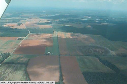 |
(Click on the photo to enlarge) |
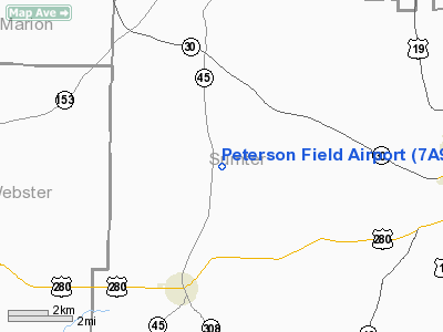
Location
& QuickFacts
|
FAA Information Effective: |
2007-07-05 |
|
Airport
Identifier: |
7A9 |
|
Airport
Status: |
Operational |
|
Longitude/Latitude: |
084-22-21.0360W/32-05-19.1820N
-84.372510/32.088662 (Estimated) |
|
Elevation: |
526 ft / 160.32 m (Surveyed) |
|
Land: |
101 acres |
|
From
nearest city: |
3 nautical miles NE of Plains, GA |
|
Location: |
Sumter County, GA |
|
Magnetic Variation: |
02W (1985) |
Owner
& Manager
|
Ownership: |
Privately owned |
|
Owner: |
G. Thomas Peterson |
|
Address: |
Peterson Field
Plains, GA 31780 |
|
Phone
number: |
912-824-7788 |
|
Manager: |
G. Thomas Peterson
OWNER LIVES ON ARPT. |
|
Address: |
Peterson Field
Plains, GA 31780 |
|
Phone number: |
912-824-7788 |
Airport
Operations and Facilities
|
Airport Use: |
Open to public |
|
Wind
indicator: |
Yes |
|
Segmented
Circle: |
No |
|
Control
Tower: |
No |
|
Lighting
Schedule: |
PHONE REQ
FOR LIRL RY 18/36 CALL 912-824-7788. |
|
Landing
fee charge: |
No |
|
Sectional
chart: |
Atlanta |
|
Region: |
ASO - Southern |
|
Boundary
ARTCC: |
ZTL - Atlanta |
|
Tie-in
FSS: |
MCN - Macon |
|
FSS
on Airport: |
No |
|
FSS
Toll Free: |
1-800-WX-BRIEF |
|
NOTAMs
Facility: |
MCN (NOTAM-d service avaliable) |
Airport
Communications
|
CTAF: |
122.800 |
|
Unicom: |
122.800 |
Airport
Services
|
Runway Information
Runway 18/36
|
Dimension: |
3255 x 230 ft / 992.1 x 70.1 m |
|
Surface: |
TURF, Good Condition |
|
Edge
Lights: |
Low
SOUTH 1065' UNLGTD |
|
|
Runway 18 |
Runway 36 |
|
Longitude: |
084-22-20.6830W |
084-22-21.3880W |
|
Latitude: |
32-05-35.2840N |
32-05-03.0800N |
|
Elevation: |
525.00
ft |
524.00
ft |
|
Alignment: |
127 |
1 |
|
Traffic
Pattern: |
Left |
Left |
|
Obstruction: |
8 ft trees, 115 ft left of centerline |
8 ft trees, 0.0 ft from runway, 115 ft right
of centerline |
|
Radio Navigation
Aids
|
ID |
Type |
Name |
Ch |
Freq |
Var |
Dist |
|
LKG |
NDB |
Lindbergh |
|
242.00 |
03W |
14.4 nm |
|
IZS |
NDB |
Montezuma |
|
426.00 |
04W |
25.0 nm |
|
OHY |
NDB |
Coney |
|
400.00 |
02W |
26.6 nm |
|
AWS |
NDB |
Lawson |
|
335.00 |
02W |
35.3 nm |
|
BEP |
NDB |
Bay Creek |
|
350.00 |
03W |
38.0 nm |
|
AB |
NDB |
Putny |
|
227.00 |
02W |
38.3 nm |
|
IWJ |
NDB |
Blaak |
|
344.00 |
03W |
44.4 nm |
|
LSF |
VOR/DME |
Lawson |
051X |
111.40 |
02W |
34.8 nm |
|
PZD |
VORTAC |
Pecan |
108X |
116.10 |
02W |
26.4 nm |
|
EUF |
VORTAC |
Eufaula |
029X |
109.20 |
02E |
39.5 nm |
|
VNA |
VORTAC |
Vienna |
112X |
116.50 |
01E |
45.2 nm |
|
CSG |
VORTAC |
Columbus |
118X |
117.10 |
01E |
45.6 nm |
Remarks
- 8
FT BRUSH ALONG OLD FENCE LINE PARALLELS RY ALONG EAST SIDE 115 FT FM
CNTRLN.
Operational
Statistics
Time Period: 1999-04-28
- 2000-04-26
|
Aircraft
Operations: |
43/Week |
|
General
Aviation Local: |
50.0% |
|
General
Aviation Itinerant: |
50.0% |
Peterson Field Airport
Address:
Sumter County, GA
Tel:
912-824-7788
Images
and information placed above are from
http://www.airport-data.com/airport/7A9/
We
thank them for the data!
| General
Info |
| Country |
United
States |
| State |
GEORGIA
|
| FAA ID |
7A9
|
| Latitude |
32-05-19.182N
|
| Longitude |
084-22-21.036W
|
| Elevation |
526 feet
|
| Near City |
PLAINS
|
We don't guarantee the information is fresh and accurate. The data may
be wrong or outdated.
For more up-to-date information please refer to other sources.
|
|


