 |
|
Perry - Houston County Airport |
Coordinates: 32°30â²38â³N 083°46â²02â³W / 32.51056°N 83.76722°W / 32.51056; -83.76722
| Perry-Houston County Airport |
| IATA: none â ICAO: KPXE â FAA LID: PXE |
| Summary |
| Airport type |
Public |
| Owner |
Perry-Houston County Airport Authority |
| Serves |
Perry, Georgia |
| Elevation AMSL |
418 ft / 127 m |
| Runways |
| Direction |
Length |
Surface |
| ft |
m |
| 18/36 |
5,002 |
1,525 |
Asphalt |
| Statistics (2006) |
| Aircraft operations |
22,000 |
| Based aircraft |
67 |
| Source: Federal Aviation Administration |
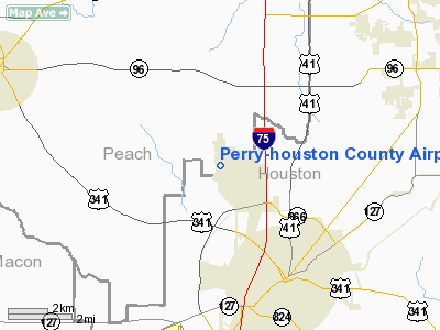
Perry-Houston County Airport (ICAO: KPXE, FAA LID: PXE) is a public airport located four miles (6 km) northwest of the central business district of Perry, a city in Houston County, Georgia, United States. It is owned by the Perry-Houston County Airport Authority. The airport is also 10 miles (16 km) south of Warner Robins, Georgia. It is used for general aviation, mainly flight training.
Although most U.S. airports use the same three-letter location identifier for the FAA and IATA, Perry-Houston County Airport is assigned PXE by the FAA but has no designation from the IATA.
Central Georgia Aviation is the fixed base operator (FBO) located on the field. They provide a number of services to include: airport management, aviation fuel, hangar leasing/sales, passenger terminal and lounge, flight training,aircraft rental, aircraft maintenance, avionics sales and service, aircraft parts and aviation accessories. History
This airfield was used during WWII for pilot training.
Facilities and aircraft
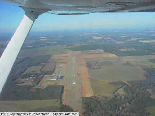
Perry-Houston County Airport covers an area of 465 acres (188 ha) and contains one asphalt paved runway designated 18/36 which measures 5,002 x 100 ft (1,525 x 30 m). For the 12-month period ending January 31, 2006, the airport had 22,000 general aviation aircraft operations, an average of 60 per day. There are 67 aircraft based at this airport: 91% single-engine, 6% multi-engine and 3% helicopter.
The above content comes from Wikipedia and is published under free licenses – click here to read more.
|
 |
(Click on the photo to enlarge) |
Location
& QuickFacts
|
FAA Information Effective: |
2007-07-05 |
|
Airport
Identifier: |
PXE |
|
Airport
Status: |
Operational |
|
Longitude/Latitude: |
083-46-02.4430W/32-30-38.0500N
-83.767345/32.510569 (Estimated) |
|
Elevation: |
418 ft / 127.41 m (Surveyed) |
|
Land: |
465 acres |
|
From
nearest city: |
4 nautical miles NW of Perry, GA |
|
Location: |
Houston County, GA |
|
Magnetic Variation: |
03W (1995) |
Owner
& Manager
|
Ownership: |
Publicly owned |
|
Owner: |
Perry-houston Co Arpt Auth
DAVID MORGAN, CHAIRMAN AIRPORT AUTHORITY. |
|
Address: |
Box 1572
Perry, GA 31069 |
|
Phone
number: |
478-988-3699 |
|
Manager: |
Terry Mcconnell |
|
Address: |
299 Myrtle Field Road
Perry, GA 31069 |
|
Phone number: |
478-988-3699
AIRPORT PHONE 912-987-3713. |
Airport
Operations and Facilities
|
Airport Use: |
Open to public |
|
Wind
indicator: |
Yes |
|
Segmented
Circle: |
Yes |
|
Control
Tower: |
No |
|
Lighting
Schedule: |
DUSK-DAWN
ACTVT MIRL RY 18/36, PAPI RYS 18 & 36 AND ODALS RY 36
- CTAF. |
|
Beacon
Color: |
Clear-Green (lighted land airport) |
|
Landing
fee charge: |
No |
|
Sectional
chart: |
Atlanta |
|
Region: |
ASO - Southern |
|
Traffic
Pattern Alt: |
800 ft |
|
Boundary
ARTCC: |
ZTL - Atlanta |
|
Tie-in
FSS: |
MCN - Macon |
|
FSS
on Airport: |
No |
|
FSS
Toll Free: |
1-800-WX-BRIEF |
|
NOTAMs
Facility: |
MCN (NOTAM-d service avaliable) |
|
Federal Agreements: |
NGRY |
Airport
Communications
|
CTAF: |
122.700 |
|
Unicom: |
122.700 |
Airport
Services
|
Fuel available: |
100LLA1+ |
|
Airframe Repair: |
MAJOR |
|
Power Plant Repair: |
MAJOR |
|
Bottled
Oxygen: |
NONE |
|
Bulk
Oxygen: |
HIGH |
|
Runway Information
Runway 18/36
|
Dimension: |
5002 x 100 ft / 1524.6 x 30.5 m |
|
Surface: |
ASPH, Good Condition |
|
Weight
Limit: |
Single wheel: 30000 lbs. |
|
Edge
Lights: |
Medium |
|
|
Runway 18 |
Runway 36 |
|
Longitude: |
083-46-02.7090W |
083-46-02.1770W |
|
Latitude: |
32-31-02.7990N |
32-30-13.3010N |
|
Elevation: |
418.00
ft |
410.00
ft |
|
Alignment: |
127 |
127 |
|
ILS
Type: |
|
LOCALIZER |
|
Traffic
Pattern: |
Left |
Left |
|
Markings: |
Non-precision instrument, Good Condition |
Non-precision instrument, Good Condition |
|
Crossing
Height: |
26.00
ft |
26.00
ft |
|
VASI: |
2-light PAPI on left side |
2-light PAPI on left side |
|
Visual
Glide Angle: |
3.00° |
3.00° |
|
Approach
lights: |
|
ODALS |
|
Runway
End Identifier: |
|
Yes |
|
Obstruction: |
, 50:1 slope to clear |
49 ft trees, 1572.0 ft from runway, 313 ft
left of centerline, 28:1 slope to clear |
|
Radio Navigation
Aids
|
ID |
Type |
Name |
Ch |
Freq |
Var |
Dist |
|
BEP |
NDB |
Bay Creek |
|
350.00 |
03W |
3.2 nm |
|
IZS |
NDB |
Montezuma |
|
426.00 |
04W |
14.9 nm |
|
LKG |
NDB |
Lindbergh |
|
242.00 |
03W |
26.6 nm |
|
OHY |
NDB |
Coney |
|
400.00 |
02W |
31.2 nm |
|
OP |
NDB |
Yates |
|
339.00 |
03W |
32.5 nm |
|
DB |
NDB |
Creke |
|
251.00 |
04W |
38.4 nm |
|
EZM |
NDB |
Eastman |
|
366.00 |
04W |
38.5 nm |
|
JHH |
NDB |
Griffin |
|
412.00 |
04W |
46.7 nm |
|
UMB |
NDB |
Culvr |
|
380.00 |
04W |
49.3 nm |
|
MCN |
VORTAC |
Macon |
089X |
114.20 |
01E |
12.4 nm |
|
VNA |
VORTAC |
Vienna |
112X |
116.50 |
01E |
22.5 nm |
|
DBN |
VORTAC |
Dublin |
078X |
113.10 |
01W |
47.4 nm |
Remarks
- GCO
AVBL ON FREQ 121.725 THRU FLT SVCS.
Based
Aircraft
|
Aircraft
based on field: |
67 |
|
Single
Engine Airplanes: |
61 |
|
Multi
Engine Airplanes: |
4 |
|
Helicopters: |
2 |
Operational Statistics
Time Period: 2005-02-01
- 2006-01-31
|
Aircraft
Operations: |
61/Day |
|
General
Aviation Local: |
45.5% |
|
General
Aviation Itinerant: |
54.5% |
Perry-houston County Airport
Address:
Houston County, GA
Tel:
478-988-3699
Images
and information placed above are from
http://www.airport-data.com/airport/PXE/
We
thank them for the data!
| General
Info |
| Country |
United
States |
| State |
GEORGIA
|
| FAA ID |
PXE
|
| Latitude |
32-30-38.100N
|
| Longitude |
083-46-02.400W
|
| Elevation |
418 feet
|
| Near City |
PERRY
|
We don't guarantee the information is fresh and accurate. The data may
be wrong or outdated.
For more up-to-date information please refer to other sources.
|
|


