 |
|
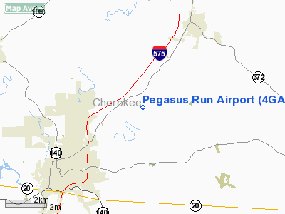
Location
& QuickFacts
|
FAA Information Effective: |
2007-07-05 |
|
Airport
Identifier: |
4GA0 |
|
Airport
Status: |
Operational |
|
Longitude/Latitude: |
084-25-16.7340W/34-16-48.3390N
-84.421315/34.280094 (Estimated) |
|
Elevation: |
900 ft / 274.32 m (Estimated) |
|
Land: |
75
acres |
|
From
nearest city: |
3 nautical miles SW of Ball Ground, GA |
|
Location: |
Cherokee County, GA |
|
Magnetic Variation: |
02W (1990) |
Owner
& Manager
|
Ownership: |
Privately owned |
|
Owner: |
T. C. Patterson |
|
Address: |
1010 Melvin Rd
Annapolis, MD 21403 |
|
Phone number: |
410-280-2463 |
|
Manager: |
T. C. Patterson |
|
Address: |
1010 Melvin Rd
Annapolis, MD 21403 |
|
Phone number: |
410-280-2463 |
Airport
Operations and Facilities
|
Airport Use: |
Private |
|
Wind
indicator: |
Yes |
|
Segmented
Circle: |
No |
|
Control
Tower: |
No |
|
Sectional
chart: |
Atlanta |
|
Region: |
ASO - Southern |
|
Boundary
ARTCC: |
ZTL - Atlanta |
|
Tie-in
FSS: |
MCN - Macon |
|
FSS
Toll Free: |
1-800-WX-BRIEF |
|
Runway Information
Runway 09/27
|
Dimension: |
3100 x 100 ft / 944.9 x 30.5 m |
|
Surface: |
TURF, |
|
|
Runway 09 |
Runway 27 |
|
Traffic
Pattern: |
Right |
Left |
|
Radio Navigation
Aids
|
ID |
Type |
Name |
Ch |
Freq |
Var |
Dist |
|
DJD |
NDB |
Canton |
|
415.00 |
04W |
3.7 nm |
|
JZP |
NDB |
Pickens County |
|
285.00 |
04W |
10.8 nm |
|
EVZ |
NDB |
Cartersville |
|
308.00 |
04W |
21.5 nm |
|
FKV |
NDB |
Flowery Branch |
|
365.00 |
03W |
26.0 nm |
|
OUK |
NDB |
Calhoun |
|
323.00 |
02W |
26.1 nm |
|
FT |
NDB |
Flanc |
|
344.00 |
02W |
33.0 nm |
|
OYD |
NDB |
Floyd |
|
388.00 |
02W |
36.9 nm |
|
BR |
NDB |
Redan |
|
266.00 |
02W |
38.5 nm |
|
UWI |
NDB |
Whitfield |
|
400.00 |
03W |
40.2 nm |
|
AJR |
NDB |
Habersham |
|
347.00 |
03W |
45.2 nm |
|
BMW |
NDB |
Barrow County |
|
404.00 |
03W |
46.3 nm |
|
DDA |
NDB |
Commerce |
|
244.00 |
03W |
46.7 nm |
|
JNM |
NDB |
Monroe |
|
392.00 |
03W |
47.5 nm |
|
DOB |
TACAN |
Dobbins |
077X |
|
01W |
22.4 nm |
|
PDK |
VOR/DME |
Peachtree |
113X |
116.60 |
02W |
25.1 nm |
|
RMG |
VORTAC |
Rome |
101X |
115.40 |
01E |
35.4 nm |
|
ATL |
VORTAC |
Atlanta |
116X |
116.90 |
00W |
39.1 nm |
|
HRS |
VORTAC |
Harris |
035X |
109.80 |
00E |
47.0 nm |
|
ATL |
VOT |
Atlanta Muni |
|
111.00 |
|
37.4 nm |
Based
Aircraft
|
Aircraft
based on field: |
1 |
|
Single
Engine Airplanes: |
1 |
Pegasus Run Airport
Address:
Cherokee County, GA
Tel:
410-280-2463
Images
and information placed above are from
http://www.airport-data.com/airport/4GA0/
We
thank them for the data!
| General
Info |
| Country |
United
States |
| State |
GEORGIA
|
| FAA ID |
4GA0
|
| Latitude |
34-16-48.339N
|
| Longitude |
084-25-16.734W
|
| Elevation |
900 feet
|
| Near City |
BALL GROUND
|
We don't guarantee the information is fresh and accurate. The data may
be wrong or outdated.
For more up-to-date information please refer to other sources.
|
|


