 |
|
| Peach State Airport |
| IATA: none – ICAO: none – FAA LID: GA2 |
| Summary |
| Airport type |
Public |
| Operator |
Peachstate Air Park Inc. |
| Location |
Williamson, Georgia |
| Elevation AMSL |
926 ft / 282 m |
| Coordinates |
33°11′00″N 84°22′18″W / 33.1833333°N 84.37167°W / 33.1833333; -84.37167Coordinates: 33°11′00″N 84°22′18″W / 33.1833333°N 84.37167°W / 33.1833333; -84.37167 |
| Runways |
| Direction |
Length |
Surface |
| ft |
m |
| 13/31 |
2,400 |
732 |
Sod |
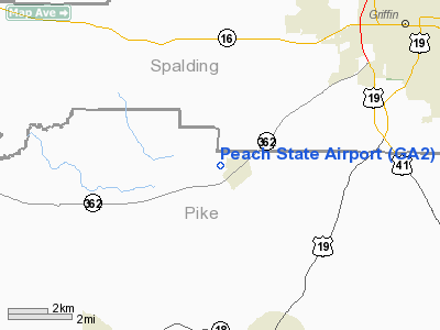
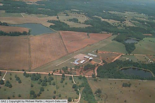
Peach State Airport (FAA LID: GA2) is a public grass strip located 1 mile (1.6 km) west of Williamson, Georgia. Peach State is in a picturesque rural area 27 nautical miles (50 km) south of Hartsfield-Jackson Atlanta International Airport. The airport is a popular fly-in destination for vintage and unusual aircraft. Hot air balloons, powered parachutes, Waco biplanes, and Piper Cubs are common sights in the area.
Peach State Airport was the original home for the Atlanta Soaring Club founded on October 4, 1986. Derek P.W. Johnson was Chief Flying Instructor and the club's CFIG.
The above content comes from Wikipedia and is published under free licenses – click here to read more.
|
 |
(Click on the photo to enlarge) |
Location
& QuickFacts
|
FAA Information Effective: |
2007-07-05 |
|
Airport
Identifier: |
GA2 |
|
Airport
Status: |
Operational |
|
Longitude/Latitude: |
084-22-17.7250W/33-11-00.4310N
-84.371590/33.183453 (Estimated) |
|
Elevation: |
926 ft / 282.24 m (Estimated) |
|
Land: |
25
acres |
|
From
nearest city: |
1 nautical miles W of Williamson, GA |
|
Location: |
Pike County, GA |
|
Magnetic Variation: |
02W (1985) |
Owner
& Manager
|
Ownership: |
Privately owned |
|
Owner: |
Peachstate Air Park Inc |
|
Address: |
185 Jonathan's Roost Rd
Williamson, GA 30292 |
|
Phone
number: |
404-227-8282 |
|
Manager: |
David Harwell |
|
Address: |
185 Jonathan's Roost Rd
Williamson, GA 30292 |
|
Phone number: |
404-227-8282 |
Airport
Operations and Facilities
|
Airport Use: |
Open to public |
|
Wind
indicator: |
Yes |
|
Segmented
Circle: |
No |
|
Control
Tower: |
No |
|
Landing
fee charge: |
No |
|
Sectional
chart: |
Atlanta |
|
Region: |
ASO - Southern |
|
Boundary
ARTCC: |
ZTL - Atlanta |
|
Tie-in
FSS: |
MCN - Macon |
|
FSS
on Airport: |
No |
|
FSS
Toll Free: |
1-800-WX-BRIEF |
|
NOTAMs
Facility: |
MCN (NOTAM-d service avaliable) |
Airport
Communications
|
CTAF: |
122.800 |
|
Unicom: |
122.800 |
Airport
Services
|
Fuel available: |
100LL |
|
Airframe Repair: |
MAJOR |
|
Power Plant Repair: |
MINOR |
|
Bottled
Oxygen: |
NONE |
|
Bulk
Oxygen: |
NONE |
|
Runway Information
Runway 13/31
|
Dimension: |
2400 x 100 ft / 731.5 x 30.5 m |
|
Surface: |
TURF, Fair Condition |
|
|
Runway 13 |
Runway 31 |
|
Traffic
Pattern: |
Right |
Left |
|
Runway
End Identifier: |
No |
No |
|
Touchdown
Lights: |
No |
No |
|
Obstruction: |
40 ft trees, 100 ft right of centerline |
30 ft fence, 150.0 ft from runway, 150 ft right
of centerline, 5:1 slope to clear |
|
Radio Navigation
Aids
|
ID |
Type |
Name |
Ch |
Freq |
Var |
Dist |
|
JHH |
NDB |
Griffin |
|
412.00 |
04W |
7.2 nm |
|
FF |
NDB |
Pecat |
|
316.00 |
02W |
9.1 nm |
|
EQQ |
NDB |
Coweta County |
|
234.00 |
03W |
17.7 nm |
|
OP |
NDB |
Yates |
|
339.00 |
03W |
18.4 nm |
|
BR |
NDB |
Redan |
|
266.00 |
02W |
27.9 nm |
|
PIM |
NDB |
Pine Mountain |
|
272.00 |
03W |
32.5 nm |
|
FT |
NDB |
Flanc |
|
344.00 |
02W |
37.3 nm |
|
VOF |
NDB |
Alcovy |
|
370.00 |
03W |
39.9 nm |
|
GPQ |
NDB |
Carrollton |
|
278.00 |
02W |
44.5 nm |
|
JNM |
NDB |
Monroe |
|
392.00 |
03W |
46.4 nm |
|
DOB |
TACAN |
Dobbins |
077X |
|
01W |
44.5 nm |
|
PDK |
VOR/DME |
Peachtree |
113X |
116.60 |
02W |
41.8 nm |
|
ATL |
VORTAC |
Atlanta |
116X |
116.90 |
00W |
27.0 nm |
|
LGC |
VORTAC |
Lagrange |
103X |
115.60 |
01E |
42.8 nm |
|
MCN |
VORTAC |
Macon |
089X |
114.20 |
01E |
47.0 nm |
|
CSG |
VORTAC |
Columbus |
118X |
117.10 |
01E |
47.2 nm |
|
ATL |
VOT |
Atlanta Muni |
|
111.00 |
|
28.6 nm |
Remarks
- RY
31 15' WIDE 760' LONG ASPH STRIP ON RY CNTRLN BEGINNING APRX 300' FROM
THR RY 31.
- VFR
OPN ONLY.
Based
Aircraft
|
Aircraft
based on field: |
21 |
|
Single
Engine Airplanes: |
20 |
|
Multi
Engine Airplanes: |
1 |
Operational Statistics
Time Period: 1999-01-13
- 2000-01-12
|
Aircraft
Operations: |
68/Week |
|
General
Aviation Local: |
78.6% |
|
General
Aviation Itinerant: |
21.4% |
Peach State Airport
Address:
Pike County, GA
Tel:
404-227-8282
Images
and information placed above are from
http://www.airport-data.com/airport/GA2/
We
thank them for the data!
| General
Info |
| Country |
United
States |
| State |
GEORGIA
|
| FAA ID |
GA2
|
| Latitude |
33-11-00.431N
|
| Longitude |
084-22-17.725W
|
| Elevation |
926 feet
|
| Near City |
WILLIAMSON
|
We don't guarantee the information is fresh and accurate. The data may
be wrong or outdated.
For more up-to-date information please refer to other sources.
|
|


