 |
|
|
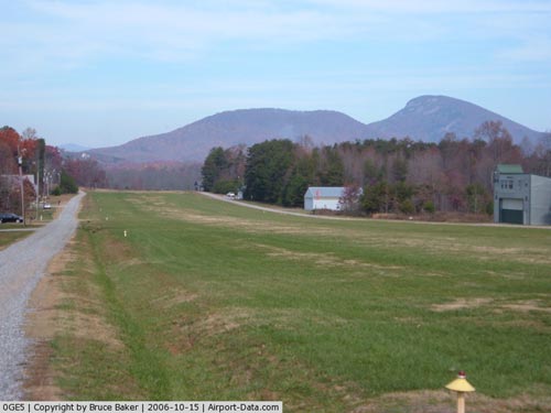 |
(Click on the photo to enlarge) |
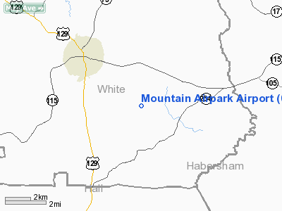
Location
& QuickFacts
|
FAA Information Effective: |
2007-07-05 |
|
Airport
Identifier: |
0GE5 |
|
Airport
Status: |
Operational |
|
Longitude/Latitude: |
083-42-48.6460W/34-33-42.3480N
-83.713513/34.561763 (Estimated) |
|
Elevation: |
1438 ft / 438.30 m (Surveyed) |
|
Land: |
20
acres |
|
From
nearest city: |
3 nautical miles SE of Cleveland, GA |
|
Location: |
White County, GA |
|
Magnetic Variation: |
03W (1985) |
Owner
& Manager
|
Ownership: |
Privately owned |
|
Owner: |
Georgia Mtn Flyers Inc |
|
Address: |
Po Box 2600
Cleveland, GA 30528 |
|
Phone
number: |
404-790-6430 |
|
Manager: |
President- Ga Mtn Flyers Inc |
|
Address: |
Po Box 2600
Cleveland, GA 30528 |
|
Phone number: |
404-790-6430 |
Airport
Operations and Facilities
|
Airport Use: |
Private |
|
Wind indicator: |
Yes |
|
Segmented Circle: |
No |
|
Control Tower: |
No |
|
Landing fee charge: |
No |
|
Sectional chart: |
Atlanta |
|
Region: |
ASO - Southern |
|
Boundary ARTCC: |
ZTL - Atlanta |
|
Tie-in FSS: |
MCN - Macon |
|
FSS on Airport: |
No |
|
FSS Toll Free: |
1-800-WX-BRIEF |
Airport
Services
|
Airframe Repair: |
MAJOR |
|
Power Plant Repair: |
MAJOR |
|
Runway Information
Runway N/S
|
Dimension: |
2500 x 200 ft / 762.0 x 61.0 m |
|
Surface: |
TURF, |
|
|
Runway N |
Runway S |
|
Traffic
Pattern: |
Left |
Left |
|
Radio Navigation
Aids
|
ID |
Type |
Name |
Ch |
Freq |
Var |
Dist |
|
AJR |
NDB |
Habersham |
|
347.00 |
03W |
8.9 nm |
|
FKV |
NDB |
Flowery Branch |
|
365.00 |
03W |
23.6 nm |
|
DDA |
NDB |
Commerce |
|
244.00 |
03W |
31.5 nm |
|
TTQ |
NDB |
Tomotla |
|
335.00 |
01W |
35.4 nm |
|
JZP |
NDB |
Pickens County |
|
285.00 |
04W |
37.5 nm |
|
BMW |
NDB |
Barrow County |
|
404.00 |
03W |
38.2 nm |
|
CEU |
NDB |
Clemson |
|
257.00 |
05W |
41.4 nm |
|
DJD |
NDB |
Canton |
|
415.00 |
04W |
42.7 nm |
|
BJT |
NDB |
Bulldog |
|
221.00 |
03W |
44.1 nm |
|
JNM |
NDB |
Monroe |
|
392.00 |
03W |
49.5 nm |
|
AND |
NDB |
Anderson County |
|
230.00 |
04W |
49.9 nm |
|
ODF |
VORTAC |
Foothills |
081X |
113.40 |
00E |
22.1 nm |
|
HRS |
VORTAC |
Harris |
035X |
109.80 |
00E |
25.0 nm |
|
AHN |
VORTAC |
Athens |
33 |
109.60 |
00E |
41.7 nm |
|
ELW |
VORTAC |
Electric City |
023X |
108.60 |
00E |
46.8 nm |
Remarks
Based
Aircraft
|
Aircraft
based on field: |
20 |
|
Single
Engine Airplanes: |
19 |
|
Ultralights: |
1 |
Mountain Airpark Airport
Address:
White County, GA
Tel:
404-790-6430
Images
and information placed above are from
http://www.airport-data.com/airport/0GE5/
We
thank them for the data!
| General
Info |
| Country |
United
States |
| State |
GEORGIA
|
| FAA ID |
0GE5
|
| Latitude |
34-33-42.348N
|
| Longitude |
083-42-48.646W
|
| Elevation |
1438 feet
|
| Near City |
CLEVELAND
|
We don't guarantee the information is fresh and accurate. The data may
be wrong or outdated.
For more up-to-date information please refer to other sources.
|
|


