|
|
Moultrie Municipal Airport |
| Moultrie Municipal Airport |
 |
| IATA: MGR â ICAO: KMGR |
| Summary |
| Airport type |
Public |
| Owner |
Public |
| Operator |
City of Moultrie |
| Serves |
Moultrie, Georgia |
| Location |
Colquitt County, near Moultrie, Georgia |
| Elevation AMSL |
294 ft / 89.6 m |
| Coordinates |
31°05â²05.7â³N 083°48â²11.7â³W / 31.084917°N 83.80325°W / 31.084917; -83.80325Coordinates: 31°05â²05.7â³N 083°48â²11.7â³W / 31.084917°N 83.80325°W / 31.084917; -83.80325 |
| Runways |
| Direction |
Length |
Surface |
| ft |
m |
| 16/34 |
53,878 |
1,182 |
Asphalt |
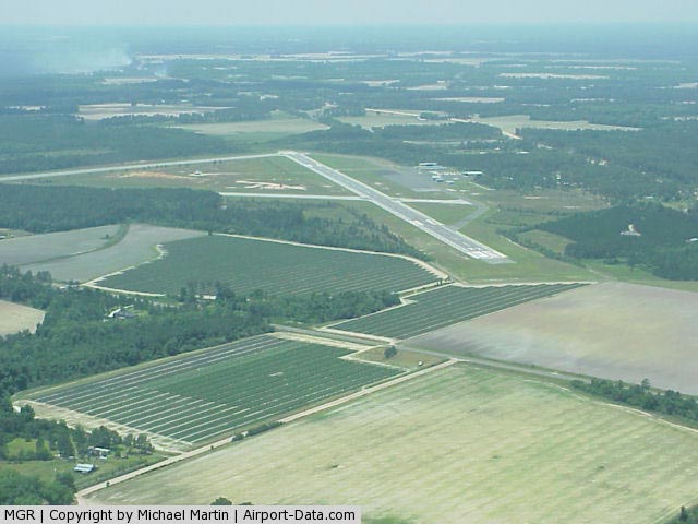
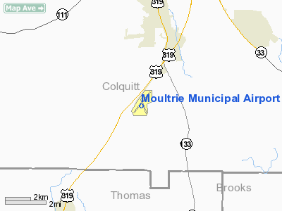
Moultrie Municipal Airport (IATA: MGR, ICAO: KMGR) is a public airport located 6 miles south of Moultrie, Georgia. The airport serves the general aviation community, with no scheduled commercial airline service. History
Moultrie Airport was built sometime before World War II. During the war, it was used as an auxiliary training airfield for Spence Army Airfield, located a few miles to the northeast. Known as Spence AAF Auxiliary No. 3 It hosted the 455th School Squadron (Special) beginning on 1 August 1941 while still being used as a civil airport.
The airfield was released from military use on 15 December 1945 and returned to full civil use as a public airport.
The above content comes from Wikipedia and is published under free licenses – click here to read more.
|
 |
(Click on the photo to enlarge) |
Location
& QuickFacts
|
FAA Information Effective: |
2007-07-05 |
|
Airport
Identifier: |
MGR |
|
Airport
Status: |
Operational |
|
Longitude/Latitude: |
083-48-11.7000W/31-05-05.7000N
-83.803250/31.084917 (Estimated) |
|
Elevation: |
294 ft / 89.61 m (Surveyed) |
|
Land: |
369 acres |
|
From
nearest city: |
6 nautical miles S of Moultrie, GA |
|
Location: |
Colquitt County, GA |
|
Magnetic Variation: |
02W (1985) |
Owner
& Manager
|
Ownership: |
Publicly owned |
|
Owner: |
City Of Moultrie |
|
Address: |
Po Box 580
Moultrie, GA 31776 |
|
Phone
number: |
229-985-1974 |
|
Manager: |
Tony Brock
CHAIRMAN ARPT AUTHORITY. |
|
Address: |
189 Airport Drive
Moultrie, GA 31778 |
|
Phone number: |
229-985-6996 |
Airport
Operations and Facilities
|
Airport Use: |
Open to public |
|
Wind
indicator: |
Yes |
|
Segmented
Circle: |
Yes |
|
Control
Tower: |
No |
|
Lighting
Schedule: |
DUSK-DAWN
MIRL RY 04/22 PRESET ON LOW INTST DUSK-2200; TO INCR INTST
& ACTVT AFTER 2200 - CTAF. |
|
Beacon
Color: |
Clear-Green (lighted land airport) |
|
Landing
fee charge: |
No |
|
Sectional
chart: |
Jacksonville |
|
Region: |
ASO - Southern |
|
Boundary
ARTCC: |
ZJX - Jacksonville |
|
Tie-in
FSS: |
MCN - Macon |
|
FSS
on Airport: |
No |
|
FSS
Toll Free: |
1-800-WX-BRIEF |
|
NOTAMs
Facility: |
MCN (NOTAM-d service avaliable) |
|
Federal Agreements: |
NGY3 |
Airport
Communications
|
CTAF: |
122.800 |
|
Unicom: |
122.800 |
Airport
Services
|
Fuel available: |
100LLA1+ |
|
Airframe Repair: |
MAJOR |
|
Power Plant Repair: |
MAJOR |
|
Bottled
Oxygen: |
HIGH |
|
Bulk
Oxygen: |
NONE |
|
Runway Information
Runway 04/22
|
Dimension: |
5129 x 100 ft / 1563.3 x 30.5 m |
|
Surface: |
ASPH, Good Condition |
|
Weight
Limit: |
Single wheel: 30000 lbs.
Dual wheel: 49000 lbs.
Dual
tandem wheel: 98000 lbs. |
|
Edge
Lights: |
Medium |
|
|
Runway 04 |
Runway 22 |
|
Longitude: |
083-48-34.1667W |
083-47-57.1519W |
|
Latitude: |
31-04-49.7738N |
31-05-29.2878N |
|
Elevation: |
269.00
ft |
294.00
ft |
|
Alignment: |
39 |
127 |
|
Traffic
Pattern: |
Left |
Left |
|
Markings: |
Non-precision instrument, Fair Condition |
Non-precision instrument, Fair Condition |
|
Crossing
Height: |
45.00
ft |
42.00
ft |
|
VASI: |
2-light PAPI on left side |
2-light PAPI on left side |
|
Visual
Glide Angle: |
3.00° |
3.00° |
|
Obstruction: |
74 ft trees, 1014.0 ft from runway, 390 ft
left of centerline, 11:1 slope to clear
RY 04 10 FT TREES & BRUSH 190 FT FROM THLD EXTENDING ACROSS
BOTH SIDES. |
58 ft trees, 2520.0 ft from runway, 400 ft
right of centerline, 40:1 slope to clear |
|
Runway 16/34
|
Dimension: |
3878 x 75 ft / 1182.0 x 22.9 m |
|
Surface: |
ASPH, Fair Condition |
|
Weight
Limit: |
Single wheel: 12500 lbs. |
|
|
Runway 16 |
Runway 34 |
|
Longitude: |
083-48-14.2823W |
083-47-58.5089W |
|
Latitude: |
31-05-18.5989N |
31-04-42.7019N |
|
Elevation: |
288.00
ft |
270.00
ft |
|
Alignment: |
127 |
127 |
|
Traffic
Pattern: |
Left |
Left |
|
Markings: |
Basic, Fair Condition |
Basic, Fair Condition |
|
Displaced
threshold: |
260.00
ft |
0.00 ft |
|
Obstruction: |
64 ft trees, 840.0 ft from runway, 175 ft right
of centerline, 10:1 slope to clear
APCH RATIO 15:1 TO DSPLCD THLD, TREES1080' FROM DISP THLD
AND 150' TO 175 R.
12' TREE 180 FT FM THLD, 10 FT R. |
54 ft trees, 216.0 ft from runway, 125 ft left
of centerline
30 FT TREES AND BRUSH 165 FT FM THLD 125 FT L. |
|
Radio Navigation
Aids
|
ID |
Type |
Name |
Ch |
Freq |
Var |
Dist |
|
GTP |
NDB |
Patten |
|
245.00 |
02W |
7.8 nm |
|
CYR |
NDB |
Caidy |
|
338.00 |
01W |
21.8 nm |
|
CXU |
NDB |
Camilla |
|
369.00 |
02W |
23.6 nm |
|
TM |
NDB |
Tifto |
|
409.00 |
03W |
24.9 nm |
|
AB |
NDB |
Putny |
|
227.00 |
02W |
33.0 nm |
|
LYZ |
NDB |
Willis |
|
359.00 |
01W |
37.8 nm |
|
SUR |
NDB |
Fitzgerald |
|
362.00 |
03W |
41.2 nm |
|
OWC |
NDB |
Coffee County |
|
390.00 |
03W |
49.1 nm |
|
IFM |
VOR |
Tift Myers |
|
112.50 |
01W |
26.2 nm |
|
MGR |
VOR/DME |
Moultrie |
025X |
108.80 |
02W |
0.2 nm |
|
OTK |
VOR/DME |
Valdosta |
095X |
114.80 |
02W |
32.6 nm |
|
GEF |
VORTAC |
Greenville |
027X |
109.00 |
01E |
32.1 nm |
|
VAD |
VORTAC |
Moody |
080X |
113.30 |
03W |
32.3 nm |
|
PZD |
VORTAC |
Pecan |
108X |
116.10 |
02W |
42.5 nm |
|
SZW |
VORTAC |
Seminole |
122X |
117.50 |
02E |
43.3 nm |
Remarks
- RY
04/22 HAS 25 FT SHOULDERS EACH SIDE OF RY.
Based
Aircraft
|
Aircraft
based on field: |
34 |
|
Single
Engine Airplanes: |
32 |
|
Multi
Engine Airplanes: |
2 |
Operational Statistics
Time Period: 2005-04-06
- 2006-04-05
|
Aircraft
Operations: |
291/Week |
|
General
Aviation Local: |
53.0% |
|
General
Aviation Itinerant: |
46.4% |
|
Military: |
0.7% |
Moultrie Municipal Airport
Address:
Colquitt County, GA
Tel:
229-985-1974,
229-985-6996
Images
and information placed above are from
http://www.airport-data.com/airport/MGR/
We
thank them for the data!
| General
Info |
| Country |
United
States |
| State |
GEORGIA
|
| FAA ID |
MGR
|
| Latitude |
31-05-05.673N
|
| Longitude |
083-48-11.719W
|
| Elevation |
294 feet
|
| Near City |
MOULTRIE
|
We don't guarantee the information is fresh and accurate. The data may
be wrong or outdated.
For more up-to-date information please refer to other sources.
|
|