 |
|
Monroe - Walton County Airport |
|
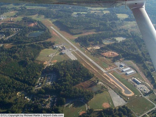 |
(Click on the photo to enlarge) |
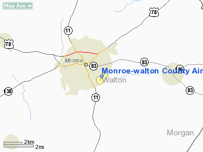
Location
& QuickFacts
|
FAA Information Effective: |
2007-07-05 |
|
Airport
Identifier: |
D73 |
|
Airport
Status: |
Operational |
|
Longitude/Latitude: |
083-41-34.3000W/33-46-56.7000N
-83.692861/33.782417 (Estimated) |
|
Elevation: |
867 ft / 264.26 m (Surveyed) |
|
Land: |
70
acres |
|
From
nearest city: |
1 nautical miles SE of Monroe, GA |
|
Location: |
Walton County, GA |
|
Magnetic Variation: |
04W (2000) |
Owner
& Manager
|
Ownership: |
Publicly owned |
|
Owner: |
City Of Monroe |
|
Address: |
City Hall, Po Box 1249
Monroe, GA 30655 |
|
Phone
number: |
770-267-7536 |
|
Manager: |
Julian Jackson, City Manager |
|
Address: |
Po Box 1249, 227 South Broad Street
Monroe, GA 30655 |
|
Phone number: |
770-267-7536 |
Airport
Operations and Facilities
|
Airport Use: |
Open to public |
|
Wind
indicator: |
Yes |
|
Segmented
Circle: |
Yes |
|
Control
Tower: |
No |
|
Lighting
Schedule: |
DUSK-DAWN
MIRL RY 03/21 PRESET LOW INTST DUSK-2200; TO INCR INTST
& ACTVT MIRL RY 03/21 AND PAPI RYS 03 & 21 AFTER
2200 - CTAF. |
|
Beacon
Color: |
Clear-Green (lighted land airport) |
|
Landing
fee charge: |
No |
|
Sectional
chart: |
Atlanta |
|
Region: |
ASO - Southern |
|
Boundary
ARTCC: |
ZTL - Atlanta |
|
Tie-in
FSS: |
MCN - Macon |
|
FSS
on Airport: |
No |
|
FSS
Toll Free: |
1-800-WX-BRIEF |
|
NOTAMs
Facility: |
MCN (NOTAM-d service avaliable) |
|
Federal Agreements: |
NGY |
Airport
Communications
Airport
Services
|
Fuel available: |
100LLA |
|
Airframe Repair: |
MAJOR |
|
Power Plant Repair: |
MAJOR |
|
Bottled
Oxygen: |
NONE |
|
Bulk
Oxygen: |
NONE |
|
Runway Information
Runway 03/21
|
Dimension: |
5000 x 75 ft / 1524.0 x 22.9 m |
|
Surface: |
ASPH, Good Condition |
|
Weight
Limit: |
Single wheel: 14500 lbs.
Dual wheel: 18000 lbs. |
|
Edge
Lights: |
Medium |
|
|
Runway 03 |
Runway 21 |
|
Longitude: |
083-41-49.5200W |
083-41-18.6300W |
|
Latitude: |
33-46-35.9700N |
33-47-18.1891N |
|
Elevation: |
870.00
ft |
825.00
ft |
|
Alignment: |
31 |
127 |
|
Traffic
Pattern: |
Left |
Left |
|
Markings: |
Non-precision instrument, Good Condition |
Non-precision instrument, Good Condition |
|
Crossing
Height: |
20.00 ft |
30.00
ft |
|
VASI: |
2-light PAPI on left side |
2-light PAPI on left side |
|
Visual
Glide Angle: |
4.00° |
4.00° |
|
Obstruction: |
40 ft trees, 200.0 ft from runway
20:1 TO DSPLCD THLD. 100 FT TREES 600 FT OUT ACROSS APCH.
ROAD; +6 FT FENCE & 30 FT TREE ACROSS CNTRLN 170-200 FT
FM THLD. |
88 ft trees, 1800.0 ft from runway, 18:1 slope
to clear |
|
Radio Navigation
Aids
|
ID |
Type |
Name |
Ch |
Freq |
Var |
Dist |
|
JNM |
NDB |
Monroe |
|
392.00 |
03W |
3.2 nm |
|
VOF |
NDB |
Alcovy |
|
370.00 |
03W |
10.2 nm |
|
BMW |
NDB |
Barrow County |
|
404.00 |
03W |
10.5 nm |
|
DDA |
NDB |
Commerce |
|
244.00 |
03W |
18.9 nm |
|
BJT |
NDB |
Bulldog |
|
221.00 |
03W |
25.7 nm |
|
FKV |
NDB |
Flowery Branch |
|
365.00 |
03W |
27.4 nm |
|
BR |
NDB |
Redan |
|
266.00 |
02W |
32.0 nm |
|
VV |
NDB |
Junne |
|
353.00 |
05W |
34.6 nm |
|
AJR |
NDB |
Habersham |
|
347.00 |
03W |
43.8 nm |
|
IIY |
NDB |
Washington/wilkes County |
|
435.00 |
03W |
44.0 nm |
|
JHH |
NDB |
Griffin |
|
412.00 |
04W |
44.8 nm |
|
UMB |
NDB |
Culvr |
|
380.00 |
04W |
46.4 nm |
|
FT |
NDB |
Flanc |
|
344.00 |
02W |
47.3 nm |
|
DJD |
NDB |
Canton |
|
415.00 |
04W |
48.6 nm |
|
FF |
NDB |
Pecat |
|
316.00 |
02W |
49.2 nm |
|
DOB |
TACAN |
Dobbins |
077X |
|
01W |
41.4 nm |
|
PDK |
VOR/DME |
Peachtree |
113X |
116.60 |
02W |
30.8 nm |
|
AHN |
VORTAC |
Athens |
33 |
109.60 |
00E |
20.9 nm |
|
ATL |
VORTAC |
Atlanta |
116X |
116.90 |
00W |
38.2 nm |
|
ATL |
VOT |
Atlanta Muni |
|
111.00 |
|
37.4 nm |
Remarks
- BE
ADVISED - GLIDER OPS WI 10 NM RADIUS SFC - 5000 FT. DEER ON OR ABOUT
ARPT.
Based
Aircraft
|
Aircraft
based on field: |
39 |
|
Single
Engine Airplanes: |
29 |
|
Multi
Engine Airplanes: |
3 |
|
Jet Engine
Airplanes: |
1 |
|
Gliders: |
6 |
Operational Statistics
Time Period: 2005-01-21
- 2006-01-20
|
Aircraft
Operations: |
231/Week |
|
General
Aviation Local: |
75.0% |
|
General
Aviation Itinerant: |
25.0% |
Monroe-walton County Airport
Address:
Walton County, GA
Tel:
770-267-7536
Images
and information placed above are from
http://www.airport-data.com/airport/D73/
We
thank them for the data!
| General
Info |
| Country |
United
States |
| State |
GEORGIA
|
| FAA ID |
D73
|
| Latitude |
33-46-53.396N
|
| Longitude |
083-41-36.794W
|
| Elevation |
867 feet
|
| Near City |
MONROE
|
We don't guarantee the information is fresh and accurate. The data may
be wrong or outdated.
For more up-to-date information please refer to other sources.
|
|


