|
 |
|
||||
|
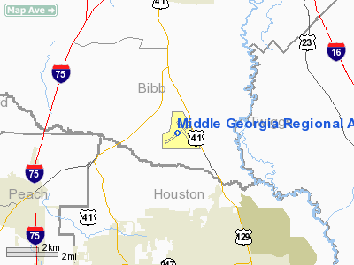
Middle Georgia Regional Airport (IATA: MCN, ICAO: KMCN) is a public airport located 9 miles (14 km) south of the city of Macon, in Bibb County, Georgia, USA. The airport has 2 runways. It is mostly used for general aviation, but is also served by two commercial airlines. Service is subsidized by Essential Air Service. Airlines
HistoryEarly in 1940, Macon's Chamber of Commerce began a campaign to bring war industries and defense installations to the City. Negotiations with the Army Air Corps resulted in a tract of land in a highly developed agricultural area nine miles south of the City known as Avondale being selected by the Air Corps. The City of Macon and Bibb County obtained options on the desired tracts of land. Once the Army Air Corps finally decided to build an airbase at the site, it required the base be built as soon as possible. An informal agreement with the Army stipulated that when the War Department had no further use for the property, the deed would revert to the City and the County. On 19 February 1941, the Army awarded a general contract for the construction of necessary temporary buildings, barracks, grading and paving of the runways and parking apron. Ground was broken on 4 March 1941. Construction proceeded at a rapid rate, only slowed at times by the delay in delivery of construction materials. The cantonment area, typical in size to other basic training schools of the war, had accommodations for 190 officers, 475 cadets, and 1,660 enlisted men. The original plan called for administration buildings, 13 cadet barracks, 35 enlisted barracks, four BOQs, six mess halls, and various other structures to support a complement of 216 airplanes. The airfield was named Cochran Army Airfield in memory of Camilla, Ga native Lt. Robert J. Cochran of the 8th Aero Squadron. who lost his life in World War I. It was assigned to the AAF Southeast Training Center. Unlike other Army Airfields, Cochran only had two-paved runways, each 300-ft. wide by 4,500-ft. long, provided on the 700-acre landing area. No hangars were provided by the original plan. The parking apron or ramp was 450 ft. by 2,500 ft. An original cadre consisting of an advanced detachment of three officers and 65 enlisted men arrived from Gunter Field, Alabama on 15 April 1941. These squadrons had been originally formed at Maxwell Field before being sent to Gunter for training in the various squadron functions. Although far from complete, the Army Air Force Pilot School (Basic) at Macon, Georgia activated on May 15, 1941. The first three Vultee BT-13 Valiants arrived at Cochran on 23 May for instructor training and familiarization. The official opening of the field occurred on 31 May when a formation of 50 BT-13s flew over downtown Macon before landing at Cochran. The press and the people of Macon celebrated the occasion. Of the 50 aircraft, one half remained on loan while the remainder returned to Gunter. Cochran AAF had several auxiliary support airfields under its control:
On 3 June 1941, 97 cadets from Class 41-H arrived after completing primary training at Souther Army Airfield in Americus; Turner Army Airfield in Albany and Arcadia Army Airfield, Florida. The AAF named cadet classes for the projected time of finishing training during a particular year. Since the barracks had not been completed, tents provided initial housing. Flight training began on 4 June, three days ahead of schedule from an unpaved area at the southeast corner of the field, away from the runway construction. Anticipating that the runways would not be completed, Tents also provided the cadet squadron quarters and an operations office. This situation slowly improved with the paving of the base's streets. The operations building and cadet squadron building reached completion at the end of June followed by the opening of the runways in early July. The predominant aircraft used for basic training during the war was the Vultee BT-13 Valiant. The Valiant was a fixed gear monoplane powered by a 450-hp Pratt and Whitney R-985 radial engine. When Pratt and Whitney fell behind in R-985 production, Vultee substituted the Wright R-975 engine. The 1,693 Wright-powered models built received the designation BT-15. By early 1945, most of the Valiants were worn out after three years of constant use, declared obsolete, and replaced by the AT-6 Texan in the basic training role. On 17 August 1941, the first class of British Royal Air Force cadets arrived at Cochran Field. Until June 1942, Cochran was used exclusively for British training. Liaison was maintained between the RAF and the Army Air Force through a Royal Air Force Administrative Officer. British cadets differed significantly from American cadets. Firstly, British physical requirements were much lower than for American cadets. The British were either from 17 to 21 years of age or over 27 years old. Many of the older cadets, married with children, worried about their families back home. The giving of tactical training and attendant discipline, along American lines and pursuant to traditional American policy, concerned and irritated the British cadets. They believed that if they had to be trained in the U.S., they should be subject to British discipline and be taught British tactics â the Americans should handle flight training only. In addition, unlike American cadets who grew up operating a farm tractor or automobile, the most complicated device operated by the average British cadet was a bicycle. Some training bases reportedly taught British cadets how to operate a motorcycle before attempting any flight training. The last British cadets completed training in the U.S. in March 1943. With the last British class graduating in early 1943, the War Department constituted and activated the 27th Flying Training Wing (Basic) at Cochran and assigned it to the (redesignated) AAF Eastern Flying Training Command as a flying training unit. Peak training took place during 1943. From the beginning of 1944 flight training steadily diminished. Cochran ended basic training on 15 March 1945. The AAF used the cantonment area as a convalescent hospital and as a separation center after the war ended. The Air Force inactivated the base on 15 December 1945. Cochran Field, however was used as communications base until finally being closed on 1 January 1947. Following the war, Cochran was utilized for various purposes. Smart Field remained as Macon's municipal airport until 1947. After a tornado swept Smart Field, the airlines moved their operations to Cochran where they remain to this day. The passenger terminal was built in 1959 and extensively renovated in 2003. The former names of this airport were Lewis B. Wilson Municipal Airport and Macon Municipal Airport. Commercial airline service to this airport included Eastern Airlines and Delta Air Lines with its ASA "Delta Connection" discontinuing service to the airport in 2008. ASA has maintenance facility at Middle Georgia Regional Airport. The two Army built hangars still exist along with a few old warehouses. The Air Force still has a presence at the airport with a Georgia Air Guard non-flying engineering unit. The above content comes from Wikipedia and is published under free licenses – click here to read more.
Runway InformationRunway 05/23
Runway 13/31
Radio Navigation Aids
Remarks
Based Aircraft
Major Carriers Serving This Airport
Most Popular Destinations
Most Popular Aircraft
Operational StatisticsTime Period: 2005-06-01 - 2006-05-31
Middle Georgia Regional Airport Address: Bibb County, GA Tel: 478-788-3760, 478-731-8857 Images
and information placed above are from We thank them for the data!
We don't guarantee the information is fresh and accurate. The data may
be wrong or outdated.
|
||||||||||||||||||||||||||||||||||||||||||||||||||||||||||||||||||||||||||||||||||||||||||||||||||||||||||||||||||||||||||||||||||||||||||||||||||||||||||||||||||||||||||||||||||||||||||||||||||||||||||||||||||||||||||||||||||||||||||||||||||||||||||||||||||||||||||||||||||||||||||||||||||||||||||||||||||||||||||||||||||||||||||||||||||||||||||||||||||||||||||||||||||||||||||||||||||||||||||||||||||||||||||||||||||||||||||||||||||||||||||||||||

 |
|
|