 |
|
|
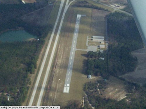 |
(Click on the photo to enlarge) |
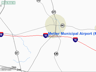
Location
& QuickFacts
|
FAA Information Effective: |
2007-07-05 |
|
Airport
Identifier: |
MHP |
|
Airport
Status: |
Operational |
|
Longitude/Latitude: |
082-04-45.1000W/32-22-26.0000N
-82.079194/32.373889 (Estimated) |
|
Elevation: |
197 ft / 60.05 m (Surveyed) |
|
Land: |
62
acres |
|
From
nearest city: |
2 nautical miles S of Metter, GA |
|
Location: |
Candler County, GA |
|
Magnetic Variation: |
03W (1985) |
Owner
& Manager
|
Ownership: |
Publicly owned |
|
Owner: |
City & County |
|
Address: |
Po Box 61
Metter, GA 30439 |
|
Phone
number: |
912-685-2527 |
|
Manager: |
Joe Neville
JOE NEVILLE, CHAIRMAN. |
|
Address: |
Box 667
Metter, GA 30417 |
|
Phone number: |
912-739-2533
ARPT PHONE 912-685-4162. |
Airport
Operations and Facilities
|
Airport Use: |
Open to public |
|
Wind
indicator: |
Yes |
|
Segmented
Circle: |
Yes |
|
Control
Tower: |
No |
|
Lighting
Schedule: |
DUSK-DAWN
MIRL RY 10/28 PRESET LOW INTST DUSK-0000; TO INCR INTST
- CTAF.
AFTER 0000, ACTVT MIRL RY 10/28 AND PAPI
RYS 10 & 28 - CTAF. |
|
Beacon
Color: |
Clear-Green (lighted land airport) |
|
Landing
fee charge: |
No |
|
Sectional
chart: |
Atlanta |
|
Region: |
ASO - Southern |
|
Boundary
ARTCC: |
ZJX - Jacksonville |
|
Tie-in
FSS: |
MCN - Macon |
|
FSS
on Airport: |
No |
|
FSS
Toll Free: |
1-800-WX-BRIEF |
|
NOTAMs
Facility: |
MCN (NOTAM-d service avaliable) |
|
Federal Agreements: |
NGY |
Airport
Communications
|
CTAF: |
123.000 |
|
Unicom: |
123.000 |
Airport
Services
|
Fuel available: |
100LL |
|
Airframe Repair: |
MINOR |
|
Power Plant Repair: |
MINOR |
|
Bottled
Oxygen: |
NONE |
|
Bulk
Oxygen: |
NONE |
|
Runway Information
Runway 10/28
|
Dimension: |
3612 x 75 ft / 1100.9 x 22.9 m |
|
Surface: |
ASPH, Good Condition |
|
Weight
Limit: |
Single wheel: 19000 lbs. |
|
Edge
Lights: |
Medium |
|
|
Runway 10 |
Runway 28 |
|
Longitude: |
082-05-06.0870W |
082-04-24.0237W |
|
Latitude: |
32-22-26.8361N |
32-22-25.1476N |
|
Elevation: |
195.00
ft |
196.00
ft |
|
Alignment: |
93 |
127 |
|
Traffic
Pattern: |
Left |
Left |
|
Markings: |
Non-precision instrument, Good Condition |
Non-precision instrument, Good Condition |
|
Crossing
Height: |
30.00
ft |
29.00
ft |
|
VASI: |
2-light PAPI on left side |
2-light PAPI on left side |
|
Visual
Glide Angle: |
3.45° |
3.35° |
|
Obstruction: |
60 ft trees, 200.0 ft from runway, 250 ft right
of centerline
+5 FT FENCE AT THLD 202 FT L. |
31 ft trees, 975.0 ft from runway, 125 ft right
of centerline, 25:1 slope to clear |
|
Radio Navigation
Aids
|
ID |
Type |
Name |
Ch |
Freq |
Var |
Dist |
|
MHP |
NDB |
Metter |
|
432.00 |
03W |
0.3 nm |
|
UQN |
NDB |
Onyun |
|
372.00 |
04W |
14.3 nm |
|
CWV |
NDB |
Claxton |
|
395.50 |
04W |
14.7 nm |
|
RVJ |
NDB |
Prison |
|
424.00 |
03W |
19.4 nm |
|
BZ |
NDB |
Bullo |
|
407.00 |
05W |
21.2 nm |
|
EEX |
NDB |
Emanuel County |
|
309.00 |
04W |
25.8 nm |
|
JYL |
NDB |
Sylvania |
|
245.00 |
04W |
29.6 nm |
|
LNH |
NDB |
Millen |
|
205.00 |
05W |
31.8 nm |
|
BXG |
NDB |
Burke County |
|
356.00 |
04W |
40.4 nm |
|
AZE |
NDB |
Hazlehurst |
|
414.00 |
03W |
41.4 nm |
|
BHC |
NDB |
Baxley |
|
376.00 |
04W |
42.8 nm |
|
MOQ |
NDB |
Mc Intosh |
|
263.00 |
04W |
43.7 nm |
|
MQW |
NDB |
Mc Rae |
|
280.00 |
03W |
44.2 nm |
|
DB |
NDB |
Creke |
|
251.00 |
04W |
47.7 nm |
|
DBN |
VORTAC |
Dublin |
078X |
113.10 |
01W |
39.9 nm |
|
SAV |
VORTAC |
Savannah |
106Y |
115.95 |
06W |
46.8 nm |
|
SAV |
VOT |
Savannah Travis Fld |
|
111.00 |
|
47.0 nm |
Based
Aircraft
|
Aircraft
based on field: |
23 |
|
Single
Engine Airplanes: |
22 |
|
Multi
Engine Airplanes: |
1 |
Operational Statistics
Time Period: 2005-06-13
- 2006-06-12
|
Aircraft
Operations: |
133/Week |
|
General
Aviation Local: |
81.2% |
|
General
Aviation Itinerant: |
17.4% |
|
Military: |
1.4% |
Metter Municipal Airport
Address:
Candler County, GA
Tel:
912-685-2527,
912-739-2533
Images
and information placed above are from
http://www.airport-data.com/airport/MHP/
We
thank them for the data!
| General
Info |
| Country |
United
States |
| State |
GEORGIA
|
| FAA ID |
MHP
|
| Latitude |
32-22-26.000N
|
| Longitude |
082-04-45.100W
|
| Elevation |
197 feet
|
| Near City |
METTER
|
We don't guarantee the information is fresh and accurate. The data may
be wrong or outdated.
For more up-to-date information please refer to other sources.
|
|


