 |
|
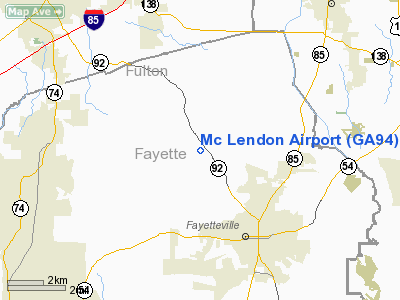
Location
& QuickFacts
|
FAA Information Effective: |
2007-07-05 |
|
Airport
Identifier: |
GA94 |
|
Airport
Status: |
Operational |
|
Longitude/Latitude: |
084-29-21.7380W/33-29-29.4090N
-84.489372/33.491503 (Estimated) |
|
Elevation: |
900 ft / 274.32 m (Estimated) |
|
Land: |
0
acres |
|
From
nearest city: |
3 nautical miles NW of Fayetteville, GA |
|
Location: |
Fayette County, GA |
|
Magnetic Variation: |
02W (1985) |
Owner
& Manager
|
Ownership: |
Privately owned |
|
Owner: |
William A. Mc Lendon |
|
Address: |
982 Hwy 92n
Fayetteville, GA 30214 |
|
Phone number: |
404-461-6524 |
|
Manager: |
William A. Mc Lendon |
|
Address: |
982 Hwy 92n
Fayetteville, GA 30214 |
|
Phone number: |
404-461-6524 |
Airport
Operations and Facilities
|
Airport Use: |
Private |
|
Wind
indicator: |
No |
|
Segmented
Circle: |
No |
|
Control
Tower: |
No |
|
Landing
fee charge: |
No |
|
Sectional
chart: |
Atlanta |
|
Region: |
ASO - Southern |
|
Boundary
ARTCC: |
ZTL - Atlanta |
|
Tie-in
FSS: |
MCN - Macon |
|
FSS
on Airport: |
No |
|
FSS
Toll Free: |
1-800-WX-BRIEF |
|
Runway Information
Runway N/S
|
Dimension: |
1433 x 75 ft / 436.8 x 22.9 m |
|
Surface: |
TURF, |
|
|
Runway N |
Runway S |
|
Traffic
Pattern: |
Left |
Left |
|
Radio Navigation
Aids
|
ID |
Type |
Name |
Ch |
Freq |
Var |
Dist |
|
FF |
NDB |
Pecat |
|
316.00 |
02W |
11.5 nm |
|
BR |
NDB |
Redan |
|
266.00 |
02W |
12.9 nm |
|
FT |
NDB |
Flanc |
|
344.00 |
02W |
17.9 nm |
|
EQQ |
NDB |
Coweta County |
|
234.00 |
03W |
18.0 nm |
|
JHH |
NDB |
Griffin |
|
412.00 |
04W |
22.7 nm |
|
GPQ |
NDB |
Carrollton |
|
278.00 |
02W |
32.5 nm |
|
VOF |
NDB |
Alcovy |
|
370.00 |
03W |
36.4 nm |
|
OP |
NDB |
Yates |
|
339.00 |
03W |
37.6 nm |
|
JNM |
NDB |
Monroe |
|
392.00 |
03W |
40.9 nm |
|
PIM |
NDB |
Pine Mountain |
|
272.00 |
03W |
43.5 nm |
|
DJD |
NDB |
Canton |
|
415.00 |
04W |
45.7 nm |
|
EVZ |
NDB |
Cartersville |
|
308.00 |
04W |
46.1 nm |
|
DOB |
TACAN |
Dobbins |
077X |
|
01W |
25.5 nm |
|
PDK |
VOR/DME |
Peachtree |
113X |
116.60 |
02W |
25.0 nm |
|
ATL |
VORTAC |
Atlanta |
116X |
116.90 |
00W |
8.7 nm |
|
LGC |
VORTAC |
Lagrange |
103X |
115.60 |
01E |
44.8 nm |
|
ATL |
VOT |
Atlanta Muni |
|
111.00 |
|
10.5 nm |
Remarks
- VFR
ONLY; PVT USE. OPERATIONAL AGREEMENT ESTABLISHED WITH BECK FIELD &G
T WOOD LANDING STRIP.
Based
Aircraft
|
Aircraft
based on field: |
1 |
|
Single
Engine Airplanes: |
1 |
Mc Lendon Airport
Address:
Fayette County, GA
Tel:
404-461-6524
Images
and information placed above are from
http://www.airport-data.com/airport/GA94/
We
thank them for the data!
| General
Info |
| Country |
United
States |
| State |
GEORGIA
|
| FAA ID |
GA94
|
| Latitude |
33-29-29.409N
|
| Longitude |
084-29-21.738W
|
| Elevation |
900 feet
|
| Near City |
FAYETTEVILLE
|
We don't guarantee the information is fresh and accurate. The data may
be wrong or outdated.
For more up-to-date information please refer to other sources.
|
|


