 |
|
Malcolm Mc Kinnon Airport |
Coordinates: 31°09â²07â³N 081°23â²29â³W / 31.15194°N 81.39139°W / 31.15194; -81.39139
Malcolm McKinnon Airport
McKinnon St. Simons Island Airport |
 |
| IATA: SSI â ICAO: KSSI â FAA LID: SSI |
| Summary |
| Airport type |
Public |
| Owner |
Glynn County |
| Serves |
Brunswick, Georgia |
| Location |
St. Simons Island |
| Elevation AMSL |
19 ft / 6 m |
| Website |
GlynnCountyAirports.com |
| Runways |
| Direction |
Length |
Surface |
| ft |
m |
| 4/22 |
5,800 |
1,768 |
Asphalt |
| 16/34 |
3,313 |
1,010 |
Asphalt |
| Statistics (2007) |
| Aircraft operations |
47,750 |
| Source: Federal Aviation Administration |
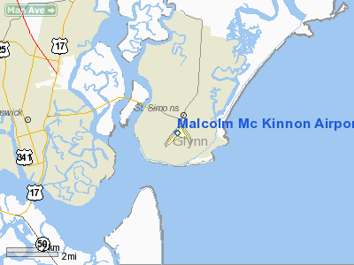
Malcolm McKinnon Airport (IATA: SSI, ICAO: KSSI, FAA LID: SSI) is a county-owned public-use airport located five miles (8 km) east of the central business district of Brunswick, a city in Glynn County, Georgia, United States.
Located on St. Simons Island, it is also known McKinnon St. Simons Island Airport. It was named for Malcom B. McKinnon, chairman of the County Commission when construction started in 1935. The airport opened on May 28, 1938, seven months after his death.
Facilities and aircraft
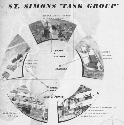 | |
Installations of the Naval Reserve Training Station in the mid-1940s. |
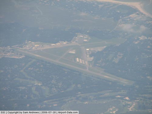
Malcolm McKinnon Airport covers an area of 320 acres (129 ha) which contains two asphalt paved runways: 4/22 measuring 5,800 x 100 ft (1,768 x 30 m) and 16/34 measuring 3,313 x 75 ft (1,010 x 23 m). For the 12-month period ending August 7, 2007, the airport had 47,750 aircraft operations, an average of 130 per day: 98% general aviation and 2% military.
The above content comes from Wikipedia and is published under free licenses – click here to read more.
|
 |
(Click on the photo to enlarge) |
Location
& QuickFacts
|
FAA Information Effective: |
2007-07-05 |
|
Airport
Identifier: |
SSI |
|
Airport
Status: |
Operational |
|
Longitude/Latitude: |
081-23-28.5100W/31-09-06.5250N
-81.391253/31.151812 (Estimated) |
|
Elevation: |
19
ft / 5.79 m (Surveyed) |
|
Land: |
320 acres |
|
From
nearest city: |
5 nautical miles E of Brunswick, GA |
|
Location: |
Glynn County, GA |
|
Magnetic Variation: |
05W (2000) |
Owner
& Manager
|
Ownership: |
Publicly owned |
|
Owner: |
Glynn County |
|
Address: |
Po Box 879
Brunswick, GA 31520 |
|
Phone number: |
912-267-5600 |
|
Manager: |
Steve Brian |
|
Address: |
500 Connole St.
Brunswick, GA 31520 |
|
Phone number: |
912-265-2070 |
Airport
Operations and Facilities
|
Airport Use: |
Open to public |
|
Wind
indicator: |
Yes |
|
Segmented
Circle: |
Yes |
|
Control
Tower: |
No |
|
Lighting
Schedule: |
DUSK-DAWN
MIRL RYS 04/22 & 16/34 AND REIL RYS 04 & 22 OPERATE
DUSK-2300; AFT 2300 ACTVT - CTAF. |
|
Beacon
Color: |
Clear-Green (lighted land airport) |
|
Landing
fee charge: |
No |
|
Sectional
chart: |
Jacksonville |
|
Region: |
ASO - Southern |
|
Boundary
ARTCC: |
ZJX - Jacksonville |
|
Tie-in
FSS: |
MCN - Macon |
|
FSS
on Airport: |
No |
|
FSS
Toll Free: |
1-800-WX-BRIEF |
|
NOTAMs
Facility: |
SSI (NOTAM-d service avaliable) |
|
Federal Agreements: |
NGPY3 |
Airport
Communications
|
CTAF: |
123.050 |
|
Unicom: |
123.050 |
Airport
Services
|
Fuel available: |
100LLA |
|
Airframe Repair: |
MAJOR |
|
Power Plant Repair: |
MAJOR |
|
Bottled
Oxygen: |
LOW |
|
Bulk
Oxygen: |
NONE |
|
Runway Information
Runway 04/22
|
Dimension: |
5800 x 100 ft / 1767.8 x 30.5 m |
|
Surface: |
ASPH, Good Condition |
|
Surface
Treatment: |
Saw-cut or plastic Grooved |
|
Weight
Limit: |
Single wheel: 45000 lbs.
Dual wheel: 60000 lbs. |
|
Edge
Lights: |
Medium |
|
|
Runway 04 |
Runway 22 |
|
Longitude: |
081-23-57.6767W |
081-23-18.3560W |
|
Latitude: |
31-08-42.8150N |
31-09-29.1990N |
|
Elevation: |
10.00 ft |
0.00 ft |
|
Alignment: |
36 |
127 |
|
Traffic
Pattern: |
Left |
Left |
|
Markings: |
Precision instrument, Good Condition |
Precision instrument, Good Condition |
|
Crossing
Height: |
36.00
ft |
54.00
ft |
|
Displaced
threshold: |
1000.00
ft |
910.00
ft |
|
VASI: |
2-light PAPI on left side |
2-light PAPI on left side |
|
Visual
Glide Angle: |
4.00° |
4.00° |
|
Runway
End Identifier: |
Yes |
Yes |
|
Obstruction: |
15 ft road, 200.0 ft from runway
RWY 04 APCH RATIO 0:1 TO DSPLCD THLD; FENCE/ROAD/+30 FT TREES
APRXLY 271 FT LEFT AT THLD.
RWY 04 6 FT FENCE 128' FROM THR ACROSS EXTENDED RWY CNTRLN
& 6' FENCE 271' LEFT AT THR. |
6 ft fence, 200.0 ft from runway
RWY 22 APCH RATIO 0:1 TO DSPLCD THLD; FENCE/ROAD/+45 FT TREES
APRXLY 287 FT RIGHT.
RWY
22 + 6 FT FENCE 100 FT OUT AND 162 FT LEFT. |
|
Decleard
distances: |
Take off run available 5800.00 ft
Take off distance available 5800.00 ft
Actual stop distance available 5800.00 ft
Landing distance available 4800.00 ft |
Take off run available 5590.00 ft
Take off distance available 5590.00 ft
Actual stop distance available 5590.00 ft
Landing distance available 4680.00 ft |
|
Runway 16/34
|
Dimension: |
3313 x 75 ft / 1009.8 x 22.9 m |
|
Surface: |
ASPH, Good Condition |
|
Weight
Limit: |
Single wheel: 14000 lbs.
Dual wheel: 30000 lbs. |
|
Edge
Lights: |
Medium |
|
|
Runway 16 |
Runway 34 |
|
Longitude: |
081-23-20.1891W |
081-23-03.5457W |
|
Latitude: |
31-09-22.1815N |
31-08-52.6788N |
|
Elevation: |
18.00 ft |
12.00 ft |
|
Alignment: |
127 |
127 |
|
Traffic
Pattern: |
Left |
Left |
|
Markings: |
Basic, Fair Condition |
Basic, Fair Condition |
|
Crossing
Height: |
44.00
ft |
53.00
ft |
|
VASI: |
2-light PAPI on left side |
2-light PAPI on left side |
|
Visual
Glide Angle: |
3.25° |
3.75° |
|
Obstruction: |
29 ft trees, 722.0 ft from runway, 150 ft right
of centerline, 18:1 slope to clear |
61 ft trees, 1115.0 ft from runway, 50 ft right
of centerline, 15:1 slope to clear |
|
Radio Navigation
Aids
|
ID |
Type |
Name |
Ch |
Freq |
Var |
Dist |
|
JUK |
NDB |
Mc Kinnon |
|
353.00 |
05W |
0.1 nm |
|
JES |
NDB |
Slover |
|
340.00 |
04W |
35.0 nm |
|
MOQ |
NDB |
Mc Intosh |
|
263.00 |
04W |
41.2 nm |
|
EYA |
NDB |
Eastport |
|
357.00 |
03W |
45.2 nm |
|
JA |
NDB |
Dinns |
|
344.00 |
03W |
46.4 nm |
|
NRB |
TACAN |
Mayport |
051X |
|
03W |
45.9 nm |
|
SSI |
VORTAC |
Brunswick |
035X |
109.80 |
04W |
6.7 nm |
|
CRG |
VORTAC |
Craig |
092X |
114.50 |
03W |
49.2 nm |
|
BQK |
VOT |
Brunswick |
|
111.00 |
|
8.1 nm |
|
JAX |
VOT |
Jacksonville Intl |
|
111.00 |
|
42.5 nm |
Remarks
- SEAGULLS
ON & IN VICINITY OF ARPT DURING HEAVY RAINS AND HIGH NORTHEASTERLY
WINDS.
- PPR
FOR ACFT OF MORE THAN 60,000 LBS DUEL WHEEL WT CTC 912-265-2070 EXT
4.
- EXISTED
PRIOR TO 1959.
Based
Aircraft
|
Aircraft
based on field: |
83 |
|
Single
Engine Airplanes: |
70 |
|
Multi
Engine Airplanes: |
12 |
|
Helicopters: |
1 |
Operational Statistics
Time Period: 2004-01-14
- 2005-01-12
|
Aircraft
Operations: |
112/Day |
|
General
Aviation Local: |
12.3% |
|
General
Aviation Itinerant: |
85.9% |
|
Military: |
1.8% |
Malcolm Mc Kinnon Airport
Address:
Glynn County, GA
Tel:
912-267-5600, 912-265-2070
Images
and information placed above are from
http://www.airport-data.com/airport/SSI/
We
thank them for the data!
| General
Info |
| Country |
United
States |
| State |
GEORGIA
|
| FAA ID |
SSI
|
| Latitude |
31-09-06.015N
|
| Longitude |
081-23-38.027W
|
| Elevation |
19 feet
|
| Near City |
BRUNSWICK
|
We don't guarantee the information is fresh and accurate. The data may
be wrong or outdated.
For more up-to-date information please refer to other sources.
|
|


