|
|
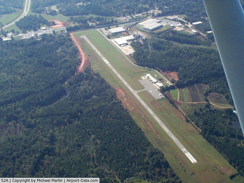
Madison Municipal Airport |
|
 |
(Click on the photo to enlarge) |
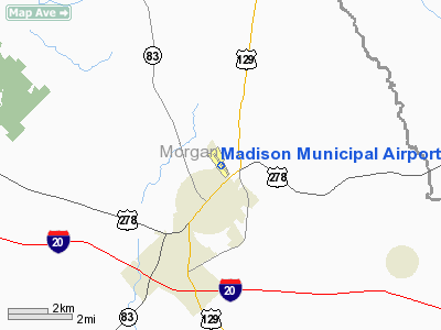
Location
& QuickFacts
|
FAA Information Effective: |
2007-07-05 |
|
Airport
Identifier: |
52A |
|
Airport
Status: |
Operational |
|
Longitude/Latitude: |
083-27-37.6000W/33-36-43.6500N
-83.460444/33.612125 (Estimated) |
|
Elevation: |
694 ft / 211.53 m (Surveyed) |
|
Land: |
70
acres |
|
From
nearest city: |
2 nautical miles NE of Madison, GA |
|
Location: |
Morgan County, GA |
|
Magnetic Variation: |
04W (1995) |
Owner
& Manager
|
Ownership: |
Publicly owned |
|
Owner: |
City Of Madison |
|
Address: |
Po Box 32
Madison, GA 30650 |
|
Phone
number: |
706-342-1251 |
|
Manager: |
Wm David Nunn
ADM ASSISTANT. |
|
Address: |
City Hall Po Box 32
Madison, GA 30650 |
|
Phone number: |
706-342-1251
ARPT PHONE 706-342-9857 |
Airport
Operations and Facilities
|
Airport Use: |
Open to public |
|
Wind
indicator: |
Yes |
|
Segmented
Circle: |
Yes |
|
Control
Tower: |
No |
|
Lighting
Schedule: |
DUSK-DAWN
ACTVT MIRL RY 14/32 & PAPI RY 14 - CTAF. |
|
Beacon
Color: |
Clear-Green (lighted land airport) |
|
Landing
fee charge: |
No |
|
Sectional
chart: |
Atlanta |
|
Region: |
ASO - Southern |
|
Boundary
ARTCC: |
ZTL - Atlanta |
|
Tie-in
FSS: |
MCN - Macon |
|
FSS
on Airport: |
No |
|
FSS
Toll Free: |
1-800-WX-BRIEF |
|
NOTAMs
Facility: |
MCN (NOTAM-d service avaliable) |
|
Federal Agreements: |
NGY |
Airport
Communications
|
CTAF: |
122.800 |
|
Unicom: |
122.800 |
Airport
Services
|
Fuel available: |
100LL |
|
Airframe Repair: |
MAJOR |
|
Power Plant Repair: |
MAJOR |
|
Bottled
Oxygen: |
NONE |
|
Bulk
Oxygen: |
NONE |
|
Runway Information
Runway 14/32
|
Dimension: |
3806 x 50 ft / 1160.1 x 15.2 m |
|
Surface: |
ASPH, Fair Condition
PAVEMENT HAS EXCESSIVE CRACKING WITH GRASS GROWING IN CRACKS &
HAS ANT HILLS. |
|
Weight
Limit: |
Single wheel: 20000 lbs. |
|
Edge
Lights: |
Medium
MIRL RWY 14/32 OUT OF SERVICE INDEFINITELY. |
|
|
Runway 14 |
Runway 32 |
|
Longitude: |
083-27-51.8300W |
083-27-23.3400W |
|
Latitude: |
33-36-58.2000N |
33-36-29.0700N |
|
Elevation: |
636.00
ft |
694.00
ft |
|
Alignment: |
127 |
127 |
|
Traffic
Pattern: |
Left |
Right |
|
Markings: |
Non-precision instrument, Good Condition |
Non-precision instrument, Good Condition |
|
Crossing
Height: |
32.00
ft |
0.00 ft |
|
Displaced
threshold: |
0.00 ft |
1131.00
ft |
|
VASI: |
2-light PAPI on left side |
|
|
Visual
Glide Angle: |
3.00° |
0.00° |
|
Obstruction: |
, 50:1 slope to clear |
58 ft trees, 606.0 ft from runway, 7:1 slope
to clear
APCH RATIO 20:1 TO DSPLCD THR, TREES 900 FT OUT 140 FT RIGHT.
RWY 32 9 FT SECURITY FENCE CROSSES APPROACH 96 FEET FRON RWY
END, AND 15 FT ROAD CROSSES APCH 196 FT FROM RWY END. |
|
Radio Navigation
Aids
|
ID |
Type |
Name |
Ch |
Freq |
Var |
Dist |
|
JNM |
NDB |
Monroe |
|
392.00 |
03W |
15.3 nm |
|
VOF |
NDB |
Alcovy |
|
370.00 |
03W |
16.1 nm |
|
BMW |
NDB |
Barrow County |
|
404.00 |
03W |
20.5 nm |
|
VV |
NDB |
Junne |
|
353.00 |
05W |
22.1 nm |
|
BJT |
NDB |
Bulldog |
|
221.00 |
03W |
23.7 nm |
|
DDA |
NDB |
Commerce |
|
244.00 |
03W |
27.2 nm |
|
UMB |
NDB |
Culvr |
|
380.00 |
04W |
31.5 nm |
|
IIY |
NDB |
Washington/wilkes County |
|
435.00 |
03W |
33.8 nm |
|
FKV |
NDB |
Flowery Branch |
|
365.00 |
03W |
41.9 nm |
|
BR |
NDB |
Redan |
|
266.00 |
02W |
42.6 nm |
|
AA |
NDB |
Cedar |
|
341.00 |
04W |
42.6 nm |
|
HIT |
NDB |
Kaolin |
|
360.00 |
05W |
44.3 nm |
|
JHH |
NDB |
Griffin |
|
412.00 |
04W |
46.3 nm |
|
HQU |
NDB |
Thomson-mcduffie |
|
333.00 |
04W |
47.6 nm |
|
PDK |
VOR/DME |
Peachtree |
113X |
116.60 |
02W |
44.8 nm |
|
AHN |
VORTAC |
Athens |
33 |
109.60 |
00E |
21.3 nm |
|
ATL |
VORTAC |
Atlanta |
116X |
116.90 |
00W |
48.8 nm |
|
ATL |
VOT |
Atlanta Muni |
|
111.00 |
|
48.4 nm |
Based
Aircraft
|
Aircraft
based on field: |
10 |
|
Single
Engine Airplanes: |
9 |
|
Multi
Engine Airplanes: |
1 |
Operational Statistics
Time Period: 2004-04-22
- 2005-04-21
|
Aircraft
Operations: |
83/Week |
|
Air Taxi: |
7.0% |
|
General
Aviation Local: |
34.9% |
|
General
Aviation Itinerant: |
58.1% |
Madison Municipal Airport
Address:
Morgan County, GA
Tel:
706-342-1251
Images
and information placed above are from
http://www.airport-data.com/airport/52A/
We
thank them for the data!
| General
Info |
| Country |
United
States |
| State |
GEORGIA
|
| FAA ID |
52A
|
| Latitude |
33-36-43.651N
|
| Longitude |
083-27-37.596W
|
| Elevation |
694 feet
|
| Near City |
MADISON
|
We don't guarantee the information is fresh and accurate. The data may
be wrong or outdated.
For more up-to-date information please refer to other sources.
|
|