|
|
Macon Downtown Airportt
Herbert Smart Downtown Airport |
 |
| IATA: MAC â ICAO: KMAC |
| Summary |
| Airport type |
Public |
| Owner |
Public |
| Operator |
City of Macon |
| Serves |
Macon, Georgia |
| Elevation AMSL |
437 ft / 133 m |
| Coordinates |
32°49â²19.7392â³N 083°33â²43.2532â³W / 32.822149778°N 83.562014778°W / 32.822149778; -83.562014778Coordinates: 32°49â²19.7392â³N 083°33â²43.2532â³W / 32.822149778°N 83.562014778°W / 32.822149778; -83.562014778 |
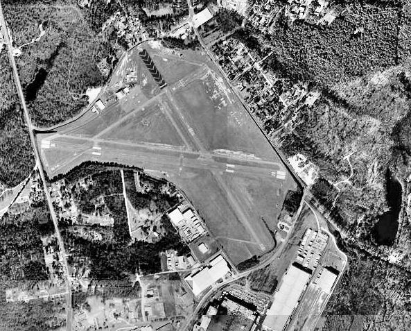
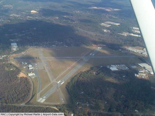
| Runways |
| Direction |
Length |
Surface |
| ft |
m |
| 10/28 |
4,696 |
1,431 |
Asphalt |
| 15/33 |
3,614 |
1,102 |
Asphalt |
Macon Downtown Airport (Also known as Herbert Smart Downtown Airport) (IATA: MAC, ICAO: KMAC) is a public airport located 3 miles southeast of Macon, Georgia. The airport serves the general aviation community, with no scheduled commercial airline service. History
Herbert Smart Airport opened in April 1940 as a commercial airport. During World War II, the airport was jointly used by the United States Army Air Forces Air Technical Service Command 5th Air Depot Group from Robins Field as a sub depot beginning on 9 November 1941 until 7 October 1944. The wartime military facility at the airport was known as Macon Army Air Base.
The above content comes from Wikipedia and is published under free licenses – click here to read more.
|
 |
(Click on the photo to enlarge) |
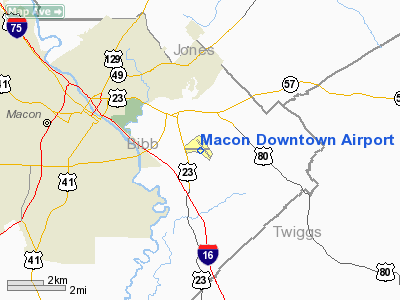
Location
& QuickFacts
|
FAA Information Effective: |
2007-07-05 |
|
Airport
Identifier: |
MAC |
|
Airport
Status: |
Operational |
|
Longitude/Latitude: |
083-33-43.2532W/32-49-19.7392N
-83.562015/32.822150 (Estimated) |
|
Elevation: |
437 ft / 133.20 m (Surveyed) |
|
Land: |
401 acres |
|
From
nearest city: |
3 nautical miles SE of Macon, GA |
|
Location: |
Bibb County, GA |
|
Magnetic Variation: |
03W (1990) |
Owner
& Manager
|
Ownership: |
Publicly owned |
|
Owner: |
City Of Macon |
|
Address: |
700 Popular Street
Macon, GA 31202 |
|
Phone
number: |
478-751-7170 |
|
Manager: |
Mike Anthony, Interim A/pdirector |
|
Address: |
1000 Terminal Drive
Macon, GA 31297
MIDDLE GEORGIA REGIONAL ARPT |
|
Phone
number: |
478-788-3760
FOR MACON DOWNTOWN FBO CALL 800-423-7510. |
Airport
Operations and Facilities
|
Airport Use: |
Open to public |
|
Wind
indicator: |
Yes |
|
Segmented
Circle: |
Yes |
|
Control
Tower: |
No |
|
Lighting
Schedule: |
DUSK-DAWN
ACTVT MIRL & VASI RYS 10 & 28 - CTAF. |
|
Beacon
Color: |
Clear-Green (lighted land airport)
ROTG BCN OTS INDEFLY. |
|
Landing
fee charge: |
Yes
FOR CERTAIN SVCS. |
|
Sectional
chart: |
Atlanta |
|
Region: |
ASO - Southern |
|
Boundary
ARTCC: |
ZTL - Atlanta |
|
Tie-in
FSS: |
MCN - Macon |
|
FSS
on Airport: |
No |
|
FSS
Toll Free: |
1-800-WX-BRIEF |
|
NOTAMs
Facility: |
MCN (NOTAM-d service avaliable) |
|
Federal Agreements: |
NGY3 |
Airport
Communications
|
CTAF: |
123.000 |
|
Unicom: |
123.000 |
Airport
Services
|
Fuel available: |
100LLA1+ |
|
Airframe Repair: |
MAJOR |
|
Power Plant Repair: |
MAJOR |
|
Bottled
Oxygen: |
HIGH/LOW |
|
Bulk
Oxygen: |
NONE |
|
Runway Information
Runway 10/28
|
Dimension: |
4696 x 150 ft / 1431.3 x 45.7 m |
|
Surface: |
ASPH, Fair Condition |
|
Weight
Limit: |
Single wheel: 20000 lbs. |
|
Edge
Lights: |
Medium
MIRL RY 10/28 OTS INDEFLY. |
|
|
Runway 10 |
Runway 28 |
|
Longitude: |
083-34-15.4458W |
083-33-20.7398W |
|
Latitude: |
32-49-22.7022N |
32-49-17.8315N |
|
Elevation: |
409.00
ft |
412.00
ft |
|
Alignment: |
96 |
127 |
|
ILS
Type: |
LOCALIZER |
|
|
Traffic
Pattern: |
Left |
Right |
|
Markings: |
Non-precision instrument, Fair Condition |
Non-precision instrument, Fair Condition |
|
VASI: |
4-box on right side |
4-box on left side |
|
Obstruction: |
20 ft trees, 240.0 ft from runway, 2:1 slope
to clear
+15 FT BRUSH/TREES 135 FT FM THHD 150 FT LEFT. |
19 ft trees, 580.0 ft from runway, 180 ft left
of centerline, 20:1 slope to clear
TREE 125' LEFT OF CNTRLN EXTDD.
+19
FT BRUSH/TREES 130 FT FM THLD 200 FT RIGHT. |
|
Runway 15/33
|
Dimension: |
3614 x 75 ft / 1101.5 x 22.9 m |
|
Surface: |
ASPH, Fair Condition |
|
Weight
Limit: |
Single wheel: 20000 lbs. |
|
|
Runway 15 |
Runway 33 |
|
Longitude: |
083-33-48.5464W |
083-33-25.3830W |
|
Latitude: |
32-49-34.0176N |
32-49-04.0897N |
|
Elevation: |
451.00
ft |
410.00
ft |
|
Alignment: |
127 |
127 |
|
Traffic
Pattern: |
Left |
Left |
|
Markings: |
Basic, Good Condition |
Basic, Good Condition |
|
Displaced
threshold: |
1000.00
ft |
0.00 ft |
|
Obstruction: |
95 ft trees, 1340.0 ft from runway, 220 ft
right of centerline, 12:1 slope to clear
25:1 TO DSPLCD THLD; 94 FT TREES 2350 FT FM THLD. |
6 ft trees, 320.0 ft from runway, 100 ft right
of centerline, 20:1 slope to clear
TREE 115' LEFT. |
|
Radio Navigation
Aids
|
ID |
Type |
Name |
Ch |
Freq |
Var |
Dist |
|
BEP |
NDB |
Bay Creek |
|
350.00 |
03W |
24.2 nm |
|
UMB |
NDB |
Culvr |
|
380.00 |
04W |
28.4 nm |
|
OP |
NDB |
Yates |
|
339.00 |
03W |
32.1 nm |
|
HIT |
NDB |
Kaolin |
|
360.00 |
05W |
33.5 nm |
|
DB |
NDB |
Creke |
|
251.00 |
04W |
34.5 nm |
|
IZS |
NDB |
Montezuma |
|
426.00 |
04W |
35.4 nm |
|
JHH |
NDB |
Griffin |
|
412.00 |
04W |
40.0 nm |
|
EZM |
NDB |
Eastman |
|
366.00 |
04W |
46.2 nm |
|
LKG |
NDB |
Lindbergh |
|
242.00 |
03W |
47.8 nm |
|
VOF |
NDB |
Alcovy |
|
370.00 |
03W |
49.8 nm |
|
MCN |
VORTAC |
Macon |
089X |
114.20 |
01E |
9.0 nm |
|
VNA |
VORTAC |
Vienna |
112X |
116.50 |
01E |
36.7 nm |
|
DBN |
VORTAC |
Dublin |
078X |
113.10 |
01W |
40.1 nm |
Remarks
- 825
FT MSL RADIO TWR LCTD APRXLY 1 MILE SE OF ARPT NEAR AER 33.
- EXISTED
PRIOR TO 1959.
Based Aircraft
|
Aircraft
based on field: |
29 |
|
Single
Engine Airplanes: |
19 |
|
Multi
Engine Airplanes: |
6 |
|
Jet Engine
Airplanes: |
2 |
|
Helicopters: |
2 |
Operational Statistics
Time Period: 2006-03-22
- 2007-03-22
|
Aircraft
Operations: |
72/Day |
|
Air Taxi: |
9.6% |
|
General
Aviation Local: |
62.1% |
|
General
Aviation Itinerant: |
27.6% |
|
Military: |
0.8% |
Macon Downtown Airport
Address:
Bibb County, GA
Tel:
478-751-7170,
478-788-3760
Images
and information placed above are from
http://www.airport-data.com/airport/MAC/
We
thank them for the data!
| General
Info |
| Country |
United
States |
| State |
GEORGIA
|
| FAA ID |
MAC
|
| Time |
UTC-5(-4DT)
|
| Latitude |
32.822139
32° 49' 19.70" N |
| Longitude |
-83.562028
083° 33' 43.30" W |
| Elevation |
437 feet
133 meters |
| Type |
Civil
|
| Magnetic
Variation |
004° W
(08/06) |
| Beacon |
Yes
|
| Operating
Agency |
U.S.CIVIL
AIRPORT WHEREIN PERMIT COVERS USE BY TRANSIT MILITARY AIRCRAFT
|
| Near City |
Macon
|
| Operating
Hours |
SEE REMARKS
FOR OPERATING HOURS OR COMMUNICATIONS FOR POSSIBLE HOURS |
| Daylight
Saving Time |
Second
Sunday in March at 0200 to first Sunday in November at 0200 local
time (Exception Arizona and that portion of Indiana in the Eastern
Time Zone) |
We don't guarantee the information is fresh and accurate. The data may
be wrong or outdated.
For more up-to-date information please refer to other sources.
|
|