 |
|
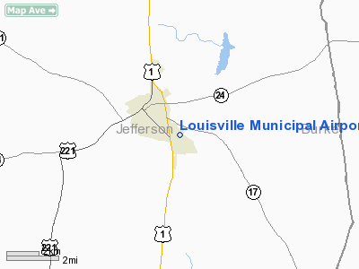
Louisville Municipal Airport |
|
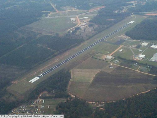 |
(Click on the photo to enlarge) |
Location
& QuickFacts
|
FAA Information Effective: |
2007-07-05 |
|
Airport
Identifier: |
2J3 |
|
Airport
Status: |
Operational |
|
Longitude/Latitude: |
082-23-08.4530W/32-59-11.5470N
-82.385681/32.986541 (Estimated) |
|
Elevation: |
328 ft / 99.97 m (Surveyed) |
|
Land: |
122 acres |
|
From
nearest city: |
2 nautical miles SE of Louisville, GA |
|
Location: |
Jefferson County, GA |
|
Magnetic Variation: |
03W (1985) |
Owner
& Manager
|
Ownership: |
Publicly owned |
|
Owner: |
City Of Louisville |
|
Address: |
City Hall
Louisville, GA 30434 |
|
Phone
number: |
478-625-3166 |
|
Manager: |
James D. Rhodes, City Mgr. |
|
Address: |
Po Box 527
Louisville, GA 30434 |
|
Phone number: |
478-625-3166 |
Airport
Operations and Facilities
|
Airport Use: |
Open to public |
|
Wind
indicator: |
Yes |
|
Segmented
Circle: |
Yes |
|
Control
Tower: |
No |
|
Lighting
Schedule: |
DUSK-DAWN
MIRL RY 13/31 PRESET MED INTST DUSK-2200; TO INCR INTST
& ACTVT AFTER 2200 - CTAF. |
|
Beacon
Color: |
Clear-Green (lighted land airport) |
|
Landing
fee charge: |
No |
|
Sectional
chart: |
Atlanta |
|
Region: |
ASO - Southern |
|
Boundary
ARTCC: |
ZTL - Atlanta |
|
Tie-in
FSS: |
MCN - Macon |
|
FSS
on Airport: |
No |
|
FSS
Toll Free: |
1-800-WX-BRIEF |
|
NOTAMs
Facility: |
MCN (NOTAM-d service avaliable) |
|
Federal Agreements: |
NY1 |
Airport
Communications
Airport
Services
|
Airframe Repair: |
MINOR |
|
Power Plant Repair: |
MINOR |
|
Bottled
Oxygen: |
NONE |
|
Bulk
Oxygen: |
NONE |
|
Runway Information
Runway 13/31
|
Dimension: |
5000 x 100 ft / 1524.0 x 30.5 m |
|
Surface: |
ASPH, Good Condition |
|
Weight
Limit: |
Single wheel: 26000 lbs. |
|
Edge
Lights: |
Medium |
|
|
Runway 13 |
Runway 31 |
|
Traffic
Pattern: |
Left |
Left |
|
Markings: |
Non-precision instrument, Good Condition |
Non-precision instrument, Good Condition |
|
Crossing
Height: |
25.00
ft |
20.00 ft |
|
VASI: |
2-light PAPI on left side |
2-light PAPI on left side |
|
Visual
Glide Angle: |
3.50° |
3.50° |
|
Obstruction: |
41 ft trees, 569.0 ft from runway, 310 ft right
of centerline, 9:1 slope to clear |
39 ft trees, 746.0 ft from runway, 14:1 slope
to clear |
|
Radio Navigation
Aids
|
ID |
Type |
Name |
Ch |
Freq |
Var |
Dist |
|
BXG |
NDB |
Burke County |
|
356.00 |
04W |
19.5 nm |
|
EEX |
NDB |
Emanuel County |
|
309.00 |
04W |
19.5 nm |
|
LNH |
NDB |
Millen |
|
205.00 |
05W |
21.8 nm |
|
HIT |
NDB |
Kaolin |
|
360.00 |
05W |
28.0 nm |
|
HQU |
NDB |
Thomson-mcduffie |
|
333.00 |
04W |
33.2 nm |
|
EMR |
NDB |
Emory |
|
385.00 |
04W |
34.7 nm |
|
AA |
NDB |
Cedar |
|
341.00 |
04W |
34.8 nm |
|
MHP |
NDB |
Metter |
|
432.00 |
03W |
39.9 nm |
|
UMB |
NDB |
Culvr |
|
380.00 |
04W |
40.2 nm |
|
DB |
NDB |
Creke |
|
251.00 |
04W |
43.7 nm |
|
JYL |
NDB |
Sylvania |
|
245.00 |
04W |
44.8 nm |
|
UQN |
NDB |
Onyun |
|
372.00 |
04W |
46.1 nm |
|
DBN |
VORTAC |
Dublin |
078X |
113.10 |
01W |
34.2 nm |
|
IRQ |
VORTAC |
Colliers |
086X |
113.90 |
04W |
44.8 nm |
Remarks
Based
Aircraft
|
Aircraft
based on field: |
20 |
|
Single
Engine Airplanes: |
20 |
Operational Statistics
Time Period: 2004-03-29
- 2005-03-28
|
Aircraft
Operations: |
154/Week |
|
General
Aviation Local: |
75.0% |
|
General
Aviation Itinerant: |
25.0% |
Louisville Municipal Airport
Address:
Jefferson County, GA
Tel:
478-625-3166
Images
and information placed above are from
http://www.airport-data.com/airport/2J3/
We
thank them for the data!
| General
Info |
| Country |
United
States |
| State |
GEORGIA
|
| FAA ID |
2J3
|
| Latitude |
32-59-11.547N
|
| Longitude |
082-23-08.453W
|
| Elevation |
328 feet
|
| Near City |
LOUISVILLE
|
We don't guarantee the information is fresh and accurate. The data may
be wrong or outdated.
For more up-to-date information please refer to other sources.
|
|


