 |
|
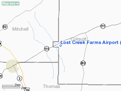
Location
& QuickFacts
|
FAA Information Effective: |
2007-07-05 |
|
Airport
Identifier: |
9GA2 |
|
Airport
Status: |
Operational |
|
Longitude/Latitude: |
083-59-55.6280W/31-06-18.6690N
-83.998786/31.105186 (Estimated) |
|
Elevation: |
310 ft / 94.49 m (Estimated) |
|
Land: |
0
acres |
|
From
nearest city: |
13 nautical miles W of Moultrie, GA |
|
Location: |
Colquitt County, GA |
|
Magnetic Variation: |
02W (1985) |
Owner
& Manager
|
Ownership: |
Privately owned |
|
Owner: |
Donald C. Sullivan |
|
Address: |
4000 Park St North
St Petersburg, FL 33709 |
|
Phone number: |
813-347-1286 |
|
Manager: |
Charles Presley |
|
Address: |
Route 1 Box 227
Meigs, GA 31765 |
|
Phone number: |
912-294-8079 |
Airport
Operations and Facilities
|
Airport Use: |
Private |
|
Wind
indicator: |
No |
|
Segmented
Circle: |
No |
|
Control
Tower: |
No |
|
Landing
fee charge: |
No |
|
Sectional
chart: |
Jacksonville |
|
Region: |
ASO - Southern |
|
Boundary
ARTCC: |
ZJX - Jacksonville |
|
Tie-in
FSS: |
MCN - Macon |
|
FSS
on Airport: |
No |
|
FSS
Toll Free: |
1-800-WX-BRIEF |
|
Runway Information
Runway 09/27
|
Dimension: |
2300 x 90 ft / 701.0 x 27.4 m |
|
Surface: |
TURF, |
|
|
Runway 09 |
Runway 27 |
|
Traffic
Pattern: |
Left |
Left |
|
Radio Navigation
Aids
|
ID |
Type |
Name |
Ch |
Freq |
Var |
Dist |
|
GTP |
NDB |
Patten |
|
245.00 |
02W |
12.5 nm |
|
CXU |
NDB |
Camilla |
|
369.00 |
02W |
13.9 nm |
|
CYR |
NDB |
Caidy |
|
338.00 |
01W |
15.4 nm |
|
AB |
NDB |
Putny |
|
227.00 |
02W |
25.5 nm |
|
LYZ |
NDB |
Willis |
|
359.00 |
01W |
28.3 nm |
|
TM |
NDB |
Tifto |
|
409.00 |
03W |
32.5 nm |
|
IWJ |
NDB |
Blaak |
|
344.00 |
03W |
47.1 nm |
|
SUR |
NDB |
Fitzgerald |
|
362.00 |
03W |
47.5 nm |
|
IFM |
VOR |
Tift Myers |
|
112.50 |
01W |
32.6 nm |
|
MGR |
VOR/DME |
Moultrie |
025X |
108.80 |
02W |
10.1 nm |
|
OTK |
VOR/DME |
Valdosta |
095X |
114.80 |
02W |
41.9 nm |
|
GEF |
VORTAC |
Greenville |
027X |
109.00 |
01E |
35.1 nm |
|
PZD |
VORTAC |
Pecan |
108X |
116.10 |
02W |
36.3 nm |
|
SZW |
VORTAC |
Seminole |
122X |
117.50 |
02E |
38.3 nm |
|
VAD |
VORTAC |
Moody |
080X |
113.30 |
03W |
42.4 nm |
|
TLH |
VOT |
Tallahassee Muni |
|
111.00 |
|
46.2 nm |
Remarks
Based
Aircraft
|
Aircraft
based on field: |
1 |
|
Single
Engine Airplanes: |
1 |
Lost Creek Farms Airport
Address:
Colquitt County, GA
Tel:
813-347-1286, 912-294-8079
Images
and information placed above are from
http://www.airport-data.com/airport/9GA2/
We
thank them for the data!
| General
Info |
| Country |
United
States |
| State |
GEORGIA
|
| FAA ID |
9GA2
|
| Latitude |
31-06-18.669N
|
| Longitude |
083-59-55.628W
|
| Elevation |
310 feet
|
| Near City |
MOULTRIE
|
We don't guarantee the information is fresh and accurate. The data may
be wrong or outdated.
For more up-to-date information please refer to other sources.
|
|


