 |
|
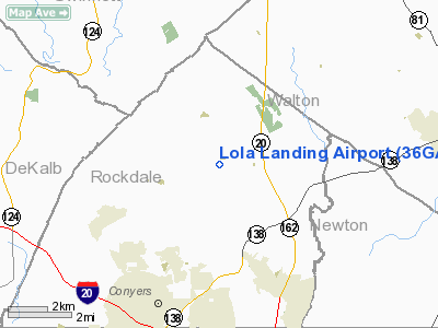
Location
& QuickFacts
|
FAA Information Effective: |
2007-07-05 |
|
Airport
Identifier: |
36GA |
|
Airport
Status: |
Operational |
|
Longitude/Latitude: |
083-58-28.6790W/33-43-48.3940N
-83.974633/33.730109 (Estimated) |
|
Elevation: |
870 ft / 265.18 m (Estimated) |
|
Land: |
0
acres |
|
From
nearest city: |
7 nautical miles S of Conyers, GA |
|
Location: |
Rockdale County, GA |
|
Magnetic Variation: |
02W (1986) |
Owner
& Manager
|
Ownership: |
Privately owned |
|
Owner: |
Lauro Guerrucci |
|
Address: |
3423 Covington, Hgwy
Decatur, GA 30032 |
|
Address: |
|
Airport
Operations and Facilities
|
Airport Use: |
Private |
|
Wind
indicator: |
Yes |
|
Segmented
Circle: |
No |
|
Control
Tower: |
No |
|
Landing
fee charge: |
No |
|
Sectional
chart: |
Atlanta |
|
Region: |
ASO - Southern |
|
Boundary
ARTCC: |
ZTL - Atlanta |
|
Tie-in
FSS: |
MCN - Macon |
|
FSS
Toll Free: |
1-800-WX-BRIEF |
|
Runway Information
Runway N/S
|
Dimension: |
1500 x 100 ft / 457.2 x 30.5 m |
|
Surface: |
TURF, |
|
|
Runway N |
Runway S |
|
Traffic
Pattern: |
Left |
Left |
|
Radio Navigation
Aids
|
ID |
Type |
Name |
Ch |
Freq |
Var |
Dist |
|
VOF |
NDB |
Alcovy |
|
370.00 |
03W |
11.4 nm |
|
JNM |
NDB |
Monroe |
|
392.00 |
03W |
12.4 nm |
|
BR |
NDB |
Redan |
|
266.00 |
02W |
17.6 nm |
|
BMW |
NDB |
Barrow County |
|
404.00 |
03W |
22.8 nm |
|
FKV |
NDB |
Flowery Branch |
|
365.00 |
03W |
28.7 nm |
|
DDA |
NDB |
Commerce |
|
244.00 |
03W |
30.2 nm |
|
FT |
NDB |
Flanc |
|
344.00 |
02W |
33.3 nm |
|
JHH |
NDB |
Griffin |
|
412.00 |
04W |
35.2 nm |
|
FF |
NDB |
Pecat |
|
316.00 |
02W |
36.4 nm |
|
BJT |
NDB |
Bulldog |
|
221.00 |
03W |
40.0 nm |
|
DJD |
NDB |
Canton |
|
415.00 |
04W |
40.5 nm |
|
EQQ |
NDB |
Coweta County |
|
234.00 |
03W |
46.7 nm |
|
VV |
NDB |
Junne |
|
353.00 |
05W |
48.0 nm |
|
OP |
NDB |
Yates |
|
339.00 |
03W |
49.9 nm |
|
JZP |
NDB |
Pickens County |
|
285.00 |
04W |
49.9 nm |
|
DOB |
TACAN |
Dobbins |
077X |
|
01W |
28.8 nm |
|
PDK |
VOR/DME |
Peachtree |
113X |
116.60 |
02W |
18.4 nm |
|
ATL |
VORTAC |
Atlanta |
116X |
116.90 |
00W |
23.8 nm |
|
AHN |
VORTAC |
Athens |
33 |
109.60 |
00E |
35.0 nm |
|
ATL |
VOT |
Atlanta Muni |
|
111.00 |
|
23.0 nm |
Remarks
- OWNER
DESIRES FIELD NOT TO BE CHARTED
- VFR,PRIVATE
USE ONLY.
Based Aircraft
|
Aircraft
based on field: |
1 |
|
Single
Engine Airplanes: |
1 |
Lola Landing Airport
Address:
Rockdale County, GA
Tel:
Images
and information placed above are from
http://www.airport-data.com/airport/36GA/
We
thank them for the data!
| General
Info |
| Country |
United
States |
| State |
GEORGIA
|
| FAA ID |
36GA
|
| Latitude |
33-43-48.394N
|
| Longitude |
083-58-28.679W
|
| Elevation |
870 feet
|
| Near City |
CONYERS
|
We don't guarantee the information is fresh and accurate. The data may
be wrong or outdated.
For more up-to-date information please refer to other sources.
|
|


