 |
|
| Liberty County Airport |
 |
| USGS aerial image, 7 March 1999 |
| IATA: none – ICAO: none – FAA LID: 2J2 |
| Summary |
| Airport type |
Public |
| Owner |
Liberty County |
| Serves |
Liberty County, Georgia |
| Location |
Hinesville, Georgia |
| Elevation AMSL |
98 ft / 30 m |
| Coordinates |
31°47′05″N 081°38′28″W / 31.78472°N 81.64111°W / 31.78472; -81.64111 (Liberty County Airport (2J2)) |
| Runways |
| Direction |
Length |
Surface |
| ft |
m |
| 14/32 |
3,698 |
1,127 |
Asphalt |
| Statistics (2006) |
| Aircraft operations |
4,000 |
| Source: Federal Aviation Administration |
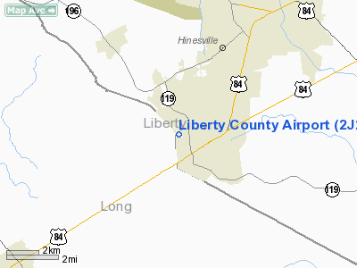
Liberty County Airport (FAA LID: 2J2) is a county-owned public-use airport in Liberty County, Georgia, United States. The airport is located five nautical miles (9 km) south of the central business district of City of Hinesville. Facilities and aircraft
Liberty County Airport covers an area of 77 acres (31 ha) at an elevation of 98 feet (30 m) above mean sea level. It has one runway designated 14/32 with an asphalt surface measuring 3,698 by 75 feet (1,127 x 23 m). For the 12-month period ending July 18, 2006, the airport had 4,000 general aviation aircraft operations, an average of 10 per day.
The above content comes from Wikipedia and is published under free licenses – click here to read more.
Location
& QuickFacts
|
FAA Information Effective: |
2007-07-05 |
|
Airport
Identifier: |
2J2 |
|
Airport
Status: |
Operational |
|
Longitude/Latitude: |
081-38-28.2000W/31-47-04.6000N
-81.641167/31.784611 (Estimated) |
|
Elevation: |
98
ft / 29.87 m (Surveyed) |
|
Land: |
77
acres |
|
From
nearest city: |
5 nautical miles S of Hinesville, GA |
|
Location: |
Liberty County, GA |
|
Magnetic Variation: |
05W (1995) |
Owner
& Manager
|
Ownership: |
Publicly owned |
|
Owner: |
Liberty County |
|
Address: |
Po Box 829
Hinesville, GA 31313 |
|
Phone
number: |
912-876-2164 |
|
Manager: |
Joseph W Brown Co Adm |
|
Address: |
Po Box 829
Hinesville, GA 31313 |
|
Phone number: |
912-876-2164 |
Airport
Operations and Facilities
|
Airport Use: |
Open to public |
|
Wind
indicator: |
Yes |
|
Segmented
Circle: |
Yes |
|
Control
Tower: |
No |
|
Lighting
Schedule: |
DUSK-DAWN
MIRL RY 14/32 PRESET HIGH INTST DUSK-2200; AFT 2200 ACTVT
- CTAF. |
|
Beacon
Color: |
Clear-Green (lighted land airport) |
|
Landing
fee charge: |
No |
|
Sectional
chart: |
Jacksonville |
|
Region: |
ASO - Southern |
|
Traffic
Pattern Alt: |
803 ft |
|
Boundary
ARTCC: |
ZJX - Jacksonville |
|
Tie-in
FSS: |
MCN - Macon |
|
FSS
on Airport: |
No |
|
FSS
Toll Free: |
1-800-WX-BRIEF |
|
NOTAMs
Facility: |
MCN (NOTAM-d service avaliable) |
|
Federal Agreements: |
NGY |
Airport
Communications
Airport
Services
|
Fuel available: |
100LL
FOR FUEL CALL 912-876-2164. |
|
Bottled
Oxygen: |
NONE |
|
Bulk
Oxygen: |
NONE |
|
Runway Information
Runway 14/32
|
Dimension: |
3698 x 75 ft / 1127.2 x 22.9 m |
|
Surface: |
ASPH, Fair Condition |
|
Weight
Limit: |
Single wheel: 23000 lbs. |
|
Edge
Lights: |
Medium
MIRL INTMT. |
|
|
Runway 14 |
Runway 32 |
|
Longitude: |
081-38-42.6362W |
081-38-13.7827W |
|
Latitude: |
31-47-18.0946N |
31-46-51.0424N |
|
Elevation: |
93.00
ft |
96.00
ft |
|
Alignment: |
127 |
127 |
|
Traffic
Pattern: |
Left |
Left |
|
Markings: |
Non-precision instrument, Fair Condition |
Non-precision instrument, Fair Condition |
|
VASI: |
2-box on left side
RY 14 VASI OTS INDEF. |
2-box on left side
RY 32 VASI OTS INDEF. |
|
Obstruction: |
21 ft trees, 515.0 ft from runway, 150 ft left
of centerline, 15:1 slope to clear |
55 ft trees, 1300.0 ft from runway, 175 ft
right of centerline, 20:1 slope to clear |
|
Radio Navigation
Aids
|
ID |
Type |
Name |
Ch |
Freq |
Var |
Dist |
|
MOQ |
NDB |
Mc Intosh |
|
263.00 |
04W |
7.3 nm |
|
JES |
NDB |
Slover |
|
340.00 |
04W |
18.8 nm |
|
CWV |
NDB |
Claxton |
|
395.50 |
04W |
27.6 nm |
|
RVJ |
NDB |
Prison |
|
424.00 |
03W |
30.8 nm |
|
BZ |
NDB |
Bullo |
|
407.00 |
05W |
37.9 nm |
|
BHC |
NDB |
Baxley |
|
376.00 |
04W |
38.5 nm |
|
JUK |
NDB |
Mc Kinnon |
|
353.00 |
05W |
40.1 nm |
|
MHP |
NDB |
Metter |
|
432.00 |
03W |
41.9 nm |
|
UQN |
NDB |
Onyun |
|
372.00 |
04W |
42.6 nm |
|
SVN |
VOR/DME |
Hunter |
53X |
111.60 |
02W |
29.0 nm |
|
SAV |
VORTAC |
Savannah |
106Y |
115.95 |
06W |
31.3 nm |
|
SSI |
VORTAC |
Brunswick |
035X |
109.80 |
04W |
45.2 nm |
|
AMG |
VORTAC |
Alma |
098X |
115.10 |
00E |
46.8 nm |
|
SAV |
VOT |
Savannah Travis Fld |
|
111.00 |
|
30.4 nm |
|
BQK |
VOT |
Brunswick |
|
111.00 |
|
32.2 nm |
Based
Aircraft
|
Aircraft
based on field: |
9 |
|
Single
Engine Airplanes: |
9 |
Operational Statistics
Time Period: 2005-07-19
- 2006-07-18
|
Aircraft
Operations: |
77/Week |
|
General
Aviation Local: |
50.0% |
|
General
Aviation Itinerant: |
50.0% |
Liberty County Airport
Address:
Liberty County, GA
Tel:
912-876-2164
Images
and information placed above are from
http://www.airport-data.com/airport/2J2/
We
thank them for the data!
| General
Info |
| Country |
United
States |
| State |
GEORGIA
|
| FAA ID |
2J2
|
| Latitude |
31-47-04.600N
|
| Longitude |
081-38-28.200W
|
| Elevation |
98 feet
|
| Near City |
HINESVILLE
|
We don't guarantee the information is fresh and accurate. The data may
be wrong or outdated.
For more up-to-date information please refer to other sources.
|
|


