 |
|
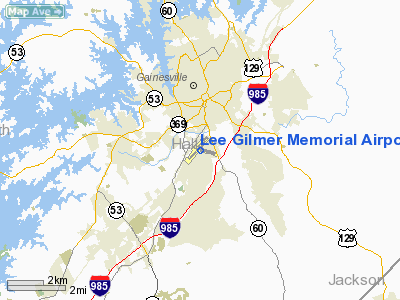
Lee Gilmer Memorial Airport |
Coordinates: 34°16â²21â³N 083°49â²49â³W / 34.2725°N 83.83028°W / 34.2725; -83.83028
| Lee Gilmer Memorial Airport |
| IATA: GVL â ICAO: KGVL â FAA LID: GVL |
| Summary |
| Airport type |
Public |
| Owner |
City of Gainesville |
| Operator |
Department of Public Works |
| Serves |
Gainesville, Georgia |
| Elevation AMSL |
1,276 ft / 389 m |
| Website |
www.gainesville.org/... |
| Runways |
| Direction |
Length |
Surface |
| ft |
m |
| 4/22 |
5,500 |
1,676 |
Asphalt |
| 11/29 |
4,001 |
1,220 |
Asphalt |
| Statistics (2007) |
| Aircraft operations |
38,800 |
| Based aircraft |
172 |
| Source: Federal Aviation Administration |
Lee Gilmer Memorial Airport (IATA: GVL, ICAO: KGVL, FAA LID: GVL) is a city-owned public-use airport located in Gainesville, a city in Hall County, Georgia, United States.
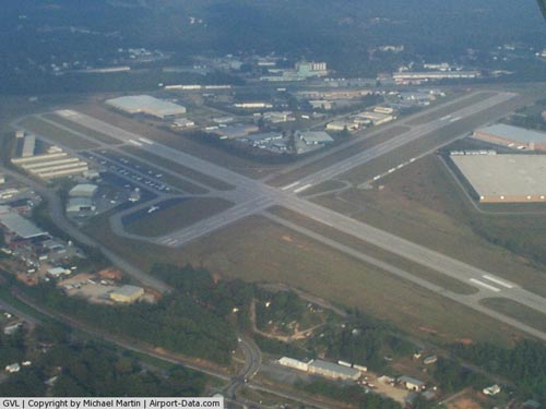
Facilities and aircraft
An untowered airport, Lee Gilmer Memorial Airport is a popular general aviation airport that covers an area of 292 acres (118 ha) which contains two asphalt paved runways: 5/23 measuring 5,500 x 100 ft (1,676 x 30 m) and 11/29 measuring 4,001 x 100 ft (1,220 x 30 m). There is a grass runway adjacent to runway 29. Owned and managed by the City of Gainesville, Georgia, it is further served by Champion Aviation (fixed based operator), AB Aviation (maintenance and repair) and Lanier Flight Center (flight school, aircraft charter and aircraft rental). Chevron and Shell full service and self-service Jet A and 100LL are available.
For the 12-month period ending March 7, 2007, the airport had 38,800 aircraft operations, an average of 106 per day: 98% general aviation, 1% air taxi and 1% military. There are 172 aircraft based at this airport:78% single-engine, 18% multi-engine, 2% jet, 2% helicopter and 1% glider.
The above content comes from Wikipedia and is published under free licenses – click here to read more.
|
 |
(Click on the photo to enlarge) |
Location
& QuickFacts
|
FAA Information Effective: |
2007-07-05 |
|
Airport
Identifier: |
GVL |
|
Airport
Status: |
Operational |
|
Longitude/Latitude: |
083-49-48.8040W/34-16-21.4572N
-83.830223/34.272627 (Estimated) |
|
Elevation: |
1275 ft / 388.62 m (Surveyed) |
|
Land: |
292 acres |
|
From
nearest city: |
0 nautical miles S of Gainesville, GA |
|
Location: |
Hall County, GA |
|
Magnetic Variation: |
03W (1985) |
Owner
& Manager
|
Ownership: |
Publicly owned |
|
Owner: |
City Of Gainesville |
|
Address: |
P.o. Box 2496
Gainesville, GA 30501 |
|
Phone number: |
770-535-6882 |
|
Manager: |
William Haley |
|
Address: |
Po Box 2496
Gainesville, GA 30501 |
|
Phone number: |
770-535-6882 |
Airport
Operations and Facilities
|
Airport Use: |
Open to public |
|
Wind
indicator: |
Yes |
|
Segmented
Circle: |
Yes |
|
Control
Tower: |
No |
|
Lighting
Schedule: |
DUSK-DAWN
ACTVT REIL RY 04 AND HIRL RY 04/22 - CTAF. |
|
Beacon
Color: |
Clear-Green (lighted land airport) |
|
Landing
fee charge: |
No |
|
Sectional
chart: |
Atlanta |
|
Region: |
ASO - Southern |
|
Boundary
ARTCC: |
ZTL - Atlanta |
|
Tie-in
FSS: |
MCN - Macon |
|
FSS
on Airport: |
No |
|
FSS
Toll Free: |
1-800-WX-BRIEF |
|
NOTAMs
Facility: |
GVL (NOTAM-d service avaliable) |
|
Federal Agreements: |
NGPY3 |
Airport
Communications
|
CTAF: |
123.075 |
|
Unicom: |
123.075 |
Airport
Services
|
Fuel available: |
100LLA1+ |
|
Airframe Repair: |
MINOR |
|
Power Plant Repair: |
MAJOR |
|
Bottled
Oxygen: |
HIGH |
|
Bulk
Oxygen: |
HIGH |
|
Runway Information
Runway 04/22
|
Dimension: |
5500 x 100 ft / 1676.4 x 30.5 m |
|
Surface: |
ASPH, Good Condition |
|
Surface
Treatment: |
Saw-cut or plastic Grooved |
|
Weight
Limit: |
Single wheel: 20000 lbs. |
|
Edge
Lights: |
High |
|
|
Runway 04 |
Runway 22 |
|
Longitude: |
083-50-16.5400W |
083-49-33.5300W |
|
Latitude: |
34-16-01.4500N |
34-16-42.5000N |
|
Elevation: |
1275.00
ft |
1237.00
ft |
|
Alignment: |
41 |
127 |
|
ILS
Type: |
LOCALIZER |
|
|
Traffic
Pattern: |
Left |
Left |
|
Markings: |
Non-precision instrument, Fair Condition |
Non-precision instrument, Fair Condition |
|
Crossing
Height: |
30.00
ft |
30.00
ft |
|
Displaced
threshold: |
0.00 ft |
130.00
ft |
|
VASI: |
2-light PAPI on left side |
2-light PAPI on left side |
|
Visual
Glide Angle: |
3.00° |
3.00° |
|
Runway
End Identifier: |
Yes |
|
|
Obstruction: |
, 50:1 slope to clear
TREE 250' LEFT. |
8 ft trees, 520.0 ft from runway, 250 ft left
of centerline, 40:1 slope to clear
TREE 250' RIGHT.
APCH SLP 50:1 TO DSPLCD THLD. |
|
Runway 11/29
|
Dimension: |
4001 x 100 ft / 1219.5 x 30.5 m |
|
Surface: |
ASPH, Fair Condition |
|
Weight
Limit: |
Single wheel: 20000 lbs. |
|
|
Runway 11 |
Runway 29 |
|
Longitude: |
083-50-02.9730W |
083-49-17.5040W |
|
Latitude: |
34-16-26.6970N |
34-16-14.7940N |
|
Elevation: |
1274.00
ft |
1260.00
ft |
|
Alignment: |
107 |
127 |
|
Traffic
Pattern: |
Left |
Left |
|
Markings: |
Basic, Fair Condition |
Basic, Fair Condition |
|
Obstruction: |
38 ft trees, 1454.0 ft from runway, 33:1 slope
to clear
TREELINE ACROSS APCH. |
31 ft trees, 665.0 ft from runway, 15:1 slope
to clear
TREES 150' RIGHT. |
|
Radio Navigation
Aids
|
ID |
Type |
Name |
Ch |
Freq |
Var |
Dist |
|
FKV |
NDB |
Flowery Branch |
|
365.00 |
03W |
5.6 nm |
|
AJR |
NDB |
Habersham |
|
347.00 |
03W |
19.6 nm |
|
DDA |
NDB |
Commerce |
|
244.00 |
03W |
19.9 nm |
|
BMW |
NDB |
Barrow County |
|
404.00 |
03W |
23.5 nm |
|
JNM |
NDB |
Monroe |
|
392.00 |
03W |
32.6 nm |
|
DJD |
NDB |
Canton |
|
415.00 |
04W |
32.7 nm |
|
JZP |
NDB |
Pickens County |
|
285.00 |
04W |
33.1 nm |
|
BJT |
NDB |
Bulldog |
|
221.00 |
03W |
36.0 nm |
|
VOF |
NDB |
Alcovy |
|
370.00 |
03W |
38.7 nm |
|
BR |
NDB |
Redan |
|
266.00 |
02W |
44.7 nm |
|
DOB |
TACAN |
Dobbins |
077X |
|
01W |
40.0 nm |
|
PDK |
VOR/DME |
Peachtree |
113X |
116.60 |
02W |
33.4 nm |
|
AHN |
VORTAC |
Athens |
33 |
109.60 |
00E |
31.9 nm |
|
ODF |
VORTAC |
Foothills |
081X |
113.40 |
00E |
36.7 nm |
|
HRS |
VORTAC |
Harris |
035X |
109.80 |
00E |
40.5 nm |
|
ATL |
VORTAC |
Atlanta |
116X |
116.90 |
00W |
49.0 nm |
|
ATL |
VOT |
Atlanta Muni |
|
111.00 |
|
47.4 nm |
Based
Aircraft
|
Aircraft
based on field: |
172 |
|
Single
Engine Airplanes: |
134 |
|
Multi
Engine Airplanes: |
31 |
|
Jet Engine
Airplanes: |
3 |
|
Helicopters: |
3 |
|
Gliders: |
1 |
Operational Statistics
Time Period: 2006-03-08
- 2007-03-07
|
Aircraft
Operations: |
107/Day |
|
Air Taxi: |
0.8% |
|
General
Aviation Local: |
51.5% |
|
General
Aviation Itinerant: |
46.4% |
|
Military: |
1.3% |
Lee Gilmer Memorial Airport
Address:
Hall County, GA
Tel:
770-535-6882
Images
and information placed above are from
http://www.airport-data.com/airport/GVL/
We
thank them for the data!
| General
Info |
| Country |
United
States |
| State |
GEORGIA
|
| FAA ID |
GVL
|
| Latitude |
34-16-22.454N
|
| Longitude |
083-49-36.528W
|
| Elevation |
1275 feet
|
| Near City |
GAINESVILLE
|
We don't guarantee the information is fresh and accurate. The data may
be wrong or outdated.
For more up-to-date information please refer to other sources.
|
|


