 |
|
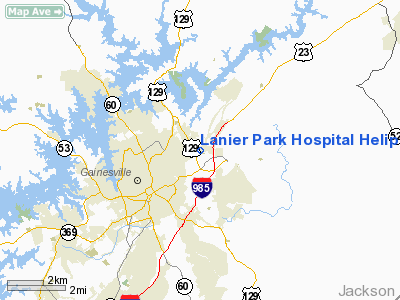
Lanier Park Hospital Heliport |
Location
& QuickFacts
|
FAA Information Effective: |
2007-07-05 |
|
Airport
Identifier: |
38GA |
|
Airport
Status: |
Operational |
|
Longitude/Latitude: |
083-47-48.0000W/34-19-11.0000N
-83.796667/34.319722 (Estimated) |
|
Elevation: |
1171 ft / 356.92 m (Surveyed) |
|
Land: |
0
acres |
|
From
nearest city: |
2 nautical miles NE of Gainesville, GA |
|
Location: |
Hall County, GA |
|
Magnetic Variation: |
03W (1985) |
Owner
& Manager
|
Ownership: |
Privately owned |
|
Owner: |
Lanier Park Hospital |
|
Address: |
675 White Sulphur Rd
Gainesville, GA 30501 |
|
Phone
number: |
404-531-2300 |
|
Manager: |
Dan Warlick |
|
Address: |
675 White Sulphur Rd
Gainesville, GA 30501 |
|
Phone number: |
404-503-3392 |
Airport
Operations and Facilities
|
Airport Use: |
Private
MEDICAL. |
|
Wind
indicator: |
Yes |
|
Segmented
Circle: |
No |
|
Control
Tower: |
No |
|
Sectional
chart: |
Atlanta |
|
Region: |
ASO - Southern |
|
Boundary
ARTCC: |
ZTL - Atlanta |
|
Tie-in
FSS: |
MCN - Macon |
|
FSS
on Airport: |
No |
|
FSS
Toll Free: |
1-800-WX-BRIEF |
|
Runway Information
Helipad H1
|
Dimension: |
60 x 60 ft / 18.3 x 18.3 m |
|
Surface: |
ASPH, |
|
|
Runway H1 |
Runway |
|
Traffic
Pattern: |
Left |
Left |
|
Radio Navigation
Aids
|
ID |
Type |
Name |
Ch |
Freq |
Var |
Dist |
|
FKV |
NDB |
Flowery Branch |
|
365.00 |
03W |
8.9 nm |
|
AJR |
NDB |
Habersham |
|
347.00 |
03W |
16.4 nm |
|
DDA |
NDB |
Commerce |
|
244.00 |
03W |
20.7 nm |
|
BMW |
NDB |
Barrow County |
|
404.00 |
03W |
25.3 nm |
|
JZP |
NDB |
Pickens County |
|
285.00 |
04W |
33.9 nm |
|
DJD |
NDB |
Canton |
|
415.00 |
04W |
34.6 nm |
|
JNM |
NDB |
Monroe |
|
392.00 |
03W |
35.2 nm |
|
BJT |
NDB |
Bulldog |
|
221.00 |
03W |
36.3 nm |
|
VOF |
NDB |
Alcovy |
|
370.00 |
03W |
41.5 nm |
|
BR |
NDB |
Redan |
|
266.00 |
02W |
48.0 nm |
|
TTQ |
NDB |
Tomotla |
|
335.00 |
01W |
48.5 nm |
|
CEU |
NDB |
Clemson |
|
257.00 |
05W |
49.8 nm |
|
DOB |
TACAN |
Dobbins |
077X |
|
01W |
42.9 nm |
|
PDK |
VOR/DME |
Peachtree |
113X |
116.60 |
02W |
36.6 nm |
|
AHN |
VORTAC |
Athens |
33 |
109.60 |
00E |
32.4 nm |
|
ODF |
VORTAC |
Foothills |
081X |
113.40 |
00E |
33.5 nm |
|
HRS |
VORTAC |
Harris |
035X |
109.80 |
00E |
37.9 nm |
Remarks
Lanier Park Hospital Heliport
Address:
Hall County, GA
Tel:
404-531-2300,
404-503-3392
Images
and information placed above are from
http://www.airport-data.com/airport/38GA/
We
thank them for the data!
| General
Info |
| Country |
United
States |
| State |
GEORGIA
|
| FAA ID |
38GA
|
| Latitude |
34-19-11.000N
|
| Longitude |
083-47-48.000W
|
| Elevation |
1171 feet
|
| Near City |
GAINESVILLE
|
We don't guarantee the information is fresh and accurate. The data may
be wrong or outdated.
For more up-to-date information please refer to other sources.
|
|


