 |
|
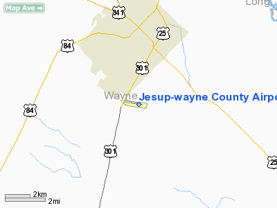
Jesup-wayne County Airport |
|
|
Location
& QuickFacts
|
FAA Information Effective: |
2007-07-05 |
|
Airport
Identifier: |
JES |
|
Airport
Status: |
Operational |
|
Longitude/Latitude: |
081-52-57.0640W/31-33-14.2680N
-81.882518/31.553963 (Estimated) |
|
Elevation: |
108 ft / 32.92 m (Surveyed) |
|
Land: |
139 acres |
|
From
nearest city: |
3 nautical miles S of Jesup, GA |
|
Location: |
Wayne County, GA |
|
Magnetic Variation: |
04W (1990) |
Owner
& Manager
|
Ownership: |
Publicly owned |
|
Owner: |
Wayne County |
|
Address: |
Po Box 217
Jesup, GA 31545 |
|
Phone number: |
912-427-5900 |
|
Manager: |
Nancy Jones, County Admin |
|
Address: |
Po Box 217
Jesup, GA 31545 |
|
Phone number: |
912-427-5900
ARPT PHONE 912-427-5949. |
Airport
Operations and Facilities
|
Airport Use: |
Open to public |
|
Wind
indicator: |
Yes |
|
Segmented
Circle: |
Yes |
|
Control
Tower: |
No |
|
Lighting
Schedule: |
DUSK-DAWN
ACTVT MIRL RY 11/29; PAPI RY 11; PAPI RY 29 & MALSF
RY 29 - CTAF. |
|
Beacon
Color: |
Clear-Green (lighted land airport) |
|
Landing
fee charge: |
No |
|
Sectional
chart: |
Jacksonville |
|
Region: |
ASO - Southern |
|
Boundary
ARTCC: |
ZJX - Jacksonville |
|
Tie-in
FSS: |
MCN - Macon |
|
FSS
on Airport: |
No |
|
FSS
Toll Free: |
1-800-WX-BRIEF |
|
NOTAMs
Facility: |
MCN (NOTAM-d service avaliable) |
|
Federal Agreements: |
NGY |
Airport
Communications
|
CTAF: |
122.800 |
|
Unicom: |
122.800 |
Airport
Services
|
Fuel available: |
100LLA |
|
Bottled
Oxygen: |
NONE |
|
Bulk
Oxygen: |
NONE |
|
Runway Information
Runway 11/29
|
Dimension: |
5500 x 100 ft / 1676.4 x 30.5 m |
|
Surface: |
ASPH, Good Condition |
|
Weight
Limit: |
Single wheel: 21500 lbs. |
|
Edge
Lights: |
Medium |
|
|
Runway 11 |
Runway 29 |
|
Longitude: |
081-53-28.4108W |
081-52-25.7186W |
|
Latitude: |
31-33-18.7501N |
31-33-09.7852N |
|
Elevation: |
108.00
ft |
73.00
ft |
|
Alignment: |
99 |
127 |
|
Traffic
Pattern: |
Left |
Left |
|
Markings: |
Non-precision instrument, Fair Condition |
Non-precision instrument, Fair Condition |
|
Crossing
Height: |
42.00
ft |
55.00
ft |
|
VASI: |
2-light PAPI on left side
PAPI OTS INDEFLY. |
2-light PAPI on left side
PAPI OTS INDEFLY. |
|
Visual
Glide Angle: |
3.50° |
0.00° |
|
Approach
lights: |
|
MALSF |
|
Obstruction: |
62 ft trees, 1440.0 ft from runway, 20:1 slope
to clear
+15 FT TREES AND BRUSH 142 FT L AND 130 FT R OF THLD. |
31 ft trees, 1440.0 ft from runway, 400 ft
right of centerline, 40:1 slope to clear |
|
Radio Navigation
Aids
|
ID |
Type |
Name |
Ch |
Freq |
Var |
Dist |
|
JES |
NDB |
Slover |
|
340.00 |
04W |
0.3 nm |
|
MOQ |
NDB |
Mc Intosh |
|
263.00 |
04W |
25.3 nm |
|
BHC |
NDB |
Baxley |
|
376.00 |
04W |
27.7 nm |
|
RVJ |
NDB |
Prison |
|
424.00 |
03W |
33.3 nm |
|
JUK |
NDB |
Mc Kinnon |
|
353.00 |
05W |
34.9 nm |
|
CWV |
NDB |
Claxton |
|
395.50 |
04W |
38.6 nm |
|
AZE |
NDB |
Hazlehurst |
|
414.00 |
03W |
43.7 nm |
|
UQN |
NDB |
Onyun |
|
372.00 |
04W |
45.5 nm |
|
SVN |
VOR/DME |
Hunter |
53X |
111.60 |
02W |
46.8 nm |
|
AMG |
VORTAC |
Alma |
098X |
115.10 |
00E |
32.1 nm |
|
SSI |
VORTAC |
Brunswick |
035X |
109.80 |
04W |
37.7 nm |
|
AYS |
VORTAC |
Waycross |
039X |
110.20 |
00E |
38.6 nm |
|
SAV |
VORTAC |
Savannah |
106Y |
115.95 |
06W |
49.9 nm |
|
BQK |
VOT |
Brunswick |
|
111.00 |
|
27.6 nm |
|
SAV |
VOT |
Savannah Travis Fld |
|
111.00 |
|
48.9 nm |
Based
Aircraft
|
Aircraft
based on field: |
11 |
|
Single
Engine Airplanes: |
8 |
|
Multi
Engine Airplanes: |
1 |
|
Ultralights: |
2 |
Operational Statistics
Time Period: 2005-03-08
- 2006-03-07
|
Aircraft
Operations: |
97/Week |
|
General
Aviation Local: |
20.0% |
|
General
Aviation Itinerant: |
80.0% |
Jesup-wayne County Airport
Address:
Wayne County, GA
Tel:
912-427-5900
Images
and information placed above are from
http://www.airport-data.com/airport/JES/
We
thank them for the data!
| General
Info |
| Country |
United
States |
| State |
GEORGIA
|
| FAA ID |
JES
|
| Latitude |
31-33-14.268N
|
| Longitude |
081-52-57.064W
|
| Elevation |
108 feet
|
| Near City |
JESUP
|
We don't guarantee the information is fresh and accurate. The data may
be wrong or outdated.
For more up-to-date information please refer to other sources.
|
|


