 |
|
|
|
|
|
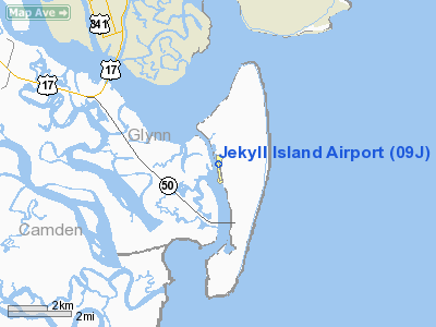
Location
& QuickFacts
|
FAA Information Effective: |
2007-07-05 |
|
Airport
Identifier: |
09J |
|
Airport
Status: |
Operational |
|
Longitude/Latitude: |
081-25-40.0000W/31-04-28.1000N
-81.427778/31.074472 (Estimated) |
|
Elevation: |
12
ft / 3.66 m (Surveyed) |
|
Land: |
100 acres |
|
From
nearest city: |
6 nautical miles SE of Jekyll Island, GA |
|
Location: |
Glynn County, GA |
|
Magnetic Variation: |
05W (1995) |
Owner
& Manager
|
Ownership: |
Publicly owned |
|
Owner: |
Jekyll Island Authority |
|
Address: |
375 Riverview Drive
Jekyll Island, GA 31527 |
|
Phone
number: |
912-635-2236 |
|
Manager: |
Bill Donohue
JEKYLL ISLAND AUTHORITY. |
|
Address: |
100 James Road
Jekyll Island, GA 31527 |
|
Phone number: |
912-635-4075 |
Airport
Operations and Facilities
|
Airport Use: |
Open to public |
|
Wind
indicator: |
Yes |
|
Segmented
Circle: |
Yes |
|
Control
Tower: |
No |
|
Lighting
Schedule: |
DUSK-DAWN |
|
Beacon
Color: |
Clear-Green (lighted land airport) |
|
Landing
fee charge: |
No |
|
Sectional
chart: |
Jacksonville |
|
Region: |
ASO - Southern |
|
Boundary
ARTCC: |
ZJX - Jacksonville |
|
Tie-in
FSS: |
MCN - Macon |
|
FSS
on Airport: |
No |
|
FSS
Toll Free: |
1-800-WX-BRIEF |
|
NOTAMs
Facility: |
MCN (NOTAM-d service avaliable) |
|
Federal Agreements: |
NGY |
Airport
Communications
|
CTAF: |
123.000 |
|
Unicom: |
123.000 |
Airport
Services
|
Airframe Repair: |
NONE |
|
Power Plant Repair: |
NONE |
|
Bottled
Oxygen: |
NONE |
|
Bulk
Oxygen: |
NONE |
|
Runway Information
Runway 18/36
|
Dimension: |
3715 x 75 ft / 1132.3 x 22.9 m |
|
Surface: |
ASPH, Good Condition |
|
Weight
Limit: |
Single wheel: 20000 lbs. |
|
Edge
Lights: |
Medium |
|
|
Runway 18 |
Runway 36 |
|
Longitude: |
081-25-42.0894W |
081-25-37.9379W |
|
Latitude: |
31-04-46.4169N |
31-04-09.8238N |
|
Elevation: |
11.00 ft |
11.00 ft |
|
Alignment: |
127 |
127 |
|
Traffic
Pattern: |
Right |
Left |
|
Markings: |
Non-precision instrument, Fair Condition
/36 MARKINGS FADED. |
Non-precision instrument, Fair Condition |
|
Crossing
Height: |
20.00 ft |
20.00 ft |
|
VASI: |
2-light PAPI on left side |
2-light PAPI on left side |
|
Visual
Glide Angle: |
3.00° |
3.00° |
|
Obstruction: |
, 50:1 slope to clear
+3 FT BRUSH 180 FT OUT ACROSS END OF RUNWAY. |
50 ft trees, 200.0 ft from runway, 160 ft right
of centerline |
|
Radio Navigation
Aids
|
ID |
Type |
Name |
Ch |
Freq |
Var |
Dist |
|
JUK |
NDB |
Mc Kinnon |
|
353.00 |
05W |
5.1 nm |
|
JES |
NDB |
Slover |
|
340.00 |
04W |
37.2 nm |
|
EYA |
NDB |
Eastport |
|
357.00 |
03W |
40.2 nm |
|
JA |
NDB |
Dinns |
|
344.00 |
03W |
41.4 nm |
|
MOQ |
NDB |
Mc Intosh |
|
263.00 |
04W |
45.6 nm |
|
NRB |
TACAN |
Mayport |
051X |
|
03W |
41.2 nm |
|
SSI |
VORTAC |
Brunswick |
035X |
109.80 |
04W |
1.7 nm |
|
CRG |
VORTAC |
Craig |
092X |
114.50 |
03W |
44.4 nm |
|
BQK |
VOT |
Brunswick |
|
111.00 |
|
12.0 nm |
|
JAX |
VOT |
Jacksonville Intl |
|
111.00 |
|
37.5 nm |
Remarks
- TRANSITION
VIOLATIONS - 55 FT PINES E OF RY.
- ROTG
BCN IS LCTD ON TOP OF A WATER TANK 1/2 - 1 MILE NE OF RY 18 IN A SWAMPY
AREA.
Operational
Statistics
Time Period: 2004-01-14
- 2005-01-12
|
Aircraft
Operations: |
39/Week |
|
General
Aviation Itinerant: |
100.0% |
Jekyll Island Airport
Address:
Glynn County, GA
Tel:
912-635-2236,
912-635-4075
Images
and information placed above are from
http://www.airport-data.com/airport/09J/
We
thank them for the data!
| General
Info |
| Country |
United
States |
| State |
GEORGIA
|
| FAA ID |
09J
|
| Latitude |
31-04-28.100N
|
| Longitude |
081-25-40.000W
|
| Elevation |
12 feet
|
| Near City |
JEKYLL
ISLAND |
We don't guarantee the information is fresh and accurate. The data may
be wrong or outdated.
For more up-to-date information please refer to other sources.
|
|


