 |
|
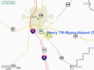
| Henry Tift Myers Airport |
 |
| IATA: TMA – ICAO: KTMA – FAA LID: TMA |
| Summary |
| Airport type |
Public |
| Owner |
Public |
| Operator |
Tifton and Tift County Airport Authority |
| Serves |
Tifton, Georgia |
| Location |
Tift County, near Tifton, Georgia |
| Elevation AMSL |
355 ft / 108.2 m |
| Coordinates |
31°25′45.58″N 083°29′20.78″W / 31.4293278°N 83.4891056°W / 31.4293278; -83.4891056Coordinates: 31°25′45.58″N 083°29′20.78″W / 31.4293278°N 83.4891056°W / 31.4293278; -83.4891056 |
| Runways |
| Direction |
Length |
Surface |
| ft |
m |
| 10/28 |
3,805 |
1,678 |
Asphalt |
| 15/33 |
5,504 |
1,160 |
Asphalt |
Henry Tift Myers Airport (IATA: TMA, ICAO: KTMA, FAA LID: TMA) is a public airport located 2 miles southeast of Tifton, Georgia. The airport serves the general aviation community, with no scheduled commercial airline service. History
The airport was constructed in 1940. In April, while under construction, the United States Army Air Corps indicated a need for the airfield as a training airfield. The immediate construction involved runways and airplane hangars, with three concrete runways, several taxiways and a large parking apron and a control tower. Several large hangars were also constructed. Buildings were ultimately utilitarian and quickly assembled. Most base buildings, not meant for long-term use, were constructed of temporary or semi-permanent materials. Although some hangars had steel frames and the occasional brick or tile brick building could be seen, most support buildings sat on concrete foundations but were of frame construction clad in little more than plywood and tarpaper.
Tifton Army Airfield (also known as Turner AAF Auxiliary Field No. 9) was activated on 12 August 1940. It was used by the Army Air Forces Flying Training Command, Southeast Training Center (later Eastern Flying Training Command) for advanced two-engine flying training throughout World War II, until inactivated on 28 December 1944. Aircraft flown at Tifton AAF were generally Curtiss AT-9s, and later TB-25 Mitchells.
Tifton AAF was placed on inactive status though the balance of the war, being turned over to the Army Corps of Engineers on 21 September 1946. Title was returned to civil authorities in 1947. The airport was renamed Henry Tift Myers Airport in honor of Tifton native Colonel Henry T. "Hank" Myers, who was the first pilot of Air Force One.
The above content comes from Wikipedia and is published under free licenses – click here to read more.
|
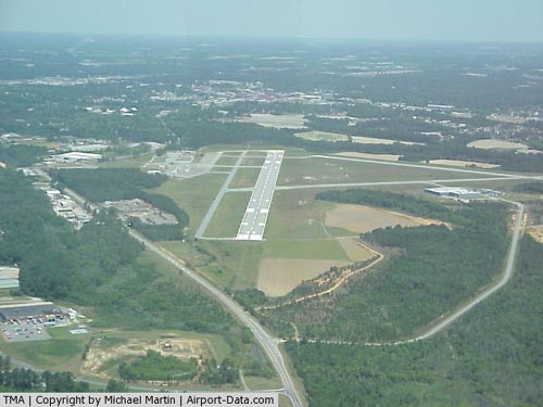 |
(Click on the photo to enlarge) |
Location
& QuickFacts
|
FAA Information Effective: |
2007-07-05 |
|
Airport
Identifier: |
TMA |
|
Airport
Status: |
Operational |
|
Longitude/Latitude: |
083-29-18.7620W/31-25-44.3330N
-83.488545/31.428981 (Estimated) |
|
Elevation: |
355 ft / 108.20 m (Surveyed) |
|
Land: |
826 acres |
|
From
nearest city: |
2 nautical miles SE of Tifton, GA |
|
Location: |
Tift County, GA |
|
Magnetic Variation: |
03W (1990) |
Owner
& Manager
|
Ownership: |
Publicly owned |
|
Owner: |
Tifton & Tift Co Arpt Auth. |
|
Address: |
Po Box 826
Tifton, GA 31793 |
|
Phone number: |
229-391-3535 |
|
Manager: |
Dr. Greg Anderson |
|
Address: |
Po Box 826
Tifton, GA 31793 |
|
Phone number: |
229-391-3535 |
Airport
Operations and Facilities
|
Airport Use: |
Open to public |
|
Wind
indicator: |
Yes |
|
Segmented
Circle: |
Yes |
|
Control
Tower: |
No |
|
Lighting
Schedule: |
DUSK-DAWN
ACTVT HIRL RY 15/33, PAPI RYS 15 AND 33, MALSR RY 33 - CTAF. |
|
Beacon
Color: |
Clear-Green (lighted land airport) |
|
Landing
fee charge: |
No |
|
Sectional
chart: |
Jacksonville |
|
Region: |
ASO - Southern |
|
Boundary
ARTCC: |
ZJX - Jacksonville |
|
Tie-in
FSS: |
MCN - Macon |
|
FSS
on Airport: |
No |
|
FSS
Toll Free: |
1-800-WX-BRIEF |
|
NOTAMs
Facility: |
MCN (NOTAM-d service avaliable) |
|
Federal Agreements: |
NGRY3 |
Airport
Communications
|
CTAF: |
122.700 |
|
Unicom: |
122.700 |
Airport
Services
|
Fuel available: |
100LLA |
|
Airframe Repair: |
MAJOR |
|
Power Plant Repair: |
MAJOR |
|
Bottled
Oxygen: |
HIGH |
|
Bulk
Oxygen: |
NONE |
|
Runway Information
Runway 10/28
|
Dimension: |
3805 x 75 ft / 1159.8 x 22.9 m |
|
Surface: |
ASPH, Good Condition |
|
Weight
Limit: |
Single wheel: 30000 lbs.
Dual wheel: 45000 lbs.
Dual
tandem wheel: 75000 lbs. |
|
|
Runway 10 |
Runway 28 |
|
Longitude: |
083-29-31.9300W |
083-28-48.1500W |
|
Latitude: |
31-25-55.1400N |
31-25-52.2300N |
|
Elevation: |
351.00
ft |
339.00
ft |
|
Alignment: |
94 |
127 |
|
Traffic
Pattern: |
Left |
Left |
|
Markings: |
Non-precision instrument, Fair Condition |
Non-precision instrument, Fair Condition |
|
Runway
End Identifier: |
No |
No |
|
Centerline
Lights: |
No |
No |
|
Touchdown
Lights: |
No |
No |
|
Obstruction: |
50 ft trees, 1300.0 ft from runway, 22:1 slope
to clear |
30 ft trees, 665.0 ft from runway, 200L/ ft
right of centerline, 15:1 slope to clear |
|
Runway 15/33
|
Dimension: |
5504 x 100 ft / 1677.6 x 30.5 m |
|
Surface: |
ASPH, Good Condition |
|
Weight
Limit: |
Single wheel: 42000 lbs.
Dual wheel: 60000 lbs.
Dual
tandem wheel: 106000 lbs. |
|
Edge
Lights: |
High |
|
|
Runway 15 |
Runway 33 |
|
Longitude: |
083-29-40.9900W |
083-29-08.5900W |
|
Latitude: |
31-26-01.3000N |
31-25-14.4400N |
|
Elevation: |
352.00
ft |
340.00
ft |
|
Alignment: |
127 |
127 |
|
ILS
Type: |
|
ILS/DME |
|
Traffic
Pattern: |
Left |
Left |
|
Markings: |
Precision instrument, Good Condition |
Precision instrument, Good Condition |
|
VASI: |
2-light PAPI on left side |
2-light PAPI on left side |
|
Approach
lights: |
|
MALSR |
|
Runway
End Identifier: |
No |
No |
|
Centerline
Lights: |
No |
No |
|
Touchdown
Lights: |
No |
No |
|
Obstruction: |
60 ft trees, 1400.0 ft from runway, 350 ft
right of centerline, 20:1 slope to clear |
16 ft trees, 600.0 ft from runway, 575 ft right
of centerline, 25:1 slope to clear
+15 FT TREES 250 FT LEFT OF THLD. |
|
Radio Navigation
Aids
|
ID |
Type |
Name |
Ch |
Freq |
Var |
Dist |
|
TM |
NDB |
Tifto |
|
409.00 |
03W |
4.6 nm |
|
SUR |
NDB |
Fitzgerald |
|
362.00 |
03W |
15.0 nm |
|
OWC |
NDB |
Coffee County |
|
390.00 |
03W |
29.0 nm |
|
GTP |
NDB |
Patten |
|
245.00 |
02W |
33.2 nm |
|
OHY |
NDB |
Coney |
|
400.00 |
02W |
39.2 nm |
|
AB |
NDB |
Putny |
|
227.00 |
02W |
40.4 nm |
|
CXU |
NDB |
Camilla |
|
369.00 |
02W |
40.5 nm |
|
HOE |
NDB |
Homerville |
|
209.00 |
03W |
43.1 nm |
|
EZM |
NDB |
Eastman |
|
366.00 |
04W |
45.7 nm |
|
CYR |
NDB |
Caidy |
|
338.00 |
01W |
47.4 nm |
|
MGR |
VOR/DME |
Moultrie |
025X |
108.80 |
02W |
26.4 nm |
|
OTK |
VOR/DME |
Valdosta |
095X |
114.80 |
02W |
40.4 nm |
|
VAD |
VORTAC |
Moody |
080X |
113.30 |
03W |
32.0 nm |
|
PZD |
VORTAC |
Pecan |
108X |
116.10 |
02W |
43.4 nm |
|
VNA |
VORTAC |
Vienna |
112X |
116.50 |
01E |
47.2 nm |
|
AYS |
VORTAC |
Waycross |
039X |
110.20 |
00E |
48.8 nm |
Remarks
- (CONTACT
TITLE) CHAIRMAN HENRY TIFT MYERS AIRPORT AUTHORITY.
- EXISTED
PRIOR TO 1959.
Based
Aircraft
|
Aircraft
based on field: |
36 |
|
Single
Engine Airplanes: |
29 |
|
Multi
Engine Airplanes: |
4 |
|
Jet Engine
Airplanes: |
2 |
|
Ultralights: |
1 |
Operational Statistics
Time Period: 2005-06-16
- 2006-06-15
|
Aircraft
Operations: |
55/Day |
|
General
Aviation Local: |
76.2% |
|
General
Aviation Itinerant: |
22.6% |
|
Military: |
1.1% |
Henry Tift Myers Airport
Address:
Tift County, GA
Tel:
229-391-3535
Images
and information placed above are from
http://www.airport-data.com/airport/TMA/
We
thank them for the data!
| General
Info |
| Country |
United
States |
| State |
GEORGIA
|
| FAA ID |
TMA
|
| Latitude |
31-25-43.663N
|
| Longitude |
083-29-16.338W
|
| Elevation |
355 feet
|
| Near City |
TIFTON
|
We don't guarantee the information is fresh and accurate. The data may
be wrong or outdated.
For more up-to-date information please refer to other sources.
|
|


