 |
|
|
|
|
|
Location
& QuickFacts
|
FAA Information Effective: |
2007-07-05 |
|
Airport
Identifier: |
AZE |
|
Airport
Status: |
Operational |
|
Longitude/Latitude: |
082-38-50.5960W/31-53-04.7630N
-82.647388/31.884656 (Estimated) |
|
Elevation: |
255 ft / 77.72 m (Surveyed) |
|
Land: |
125 acres |
|
From
nearest city: |
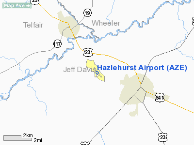
3 nautical miles NW of Hazlehurst, GA |
|
Location: |
Jeff Davis County, GA |
|
Magnetic Variation: |
03W (1985) |
Owner
& Manager
|
Ownership: |
Publicly owned |
|
Owner: |
City Of Hazlehurst |
|
Address: |
200 Latimer St
Hazelhurst, GA 31539 |
|
Phone
number: |
912-375-6680 |
|
Manager: |
Jason Shocky |
|
Address: |
528 Burketts Ferry Road
Hazlehurst, GA 31539 |
|
Phone number: |
912-375-9222 |
Airport
Operations and Facilities
|
Airport Use: |
Open to public |
|
Wind
indicator: |
Yes |
|
Segmented
Circle: |
Yes
SEGMENTED CIRCLE MKD WITH 55 GALLON BARRELS. |
|
Control
Tower: |
No |
|
Lighting
Schedule: |
DUSK-DAWN |
|
Beacon
Color: |
Clear-Green (lighted land airport) |
|
Landing
fee charge: |
No |
|
Sectional
chart: |
Jacksonville |
|
Region: |
ASO - Southern |
|
Boundary
ARTCC: |
ZJX - Jacksonville |
|
Tie-in
FSS: |
MCN - Macon |
|
FSS
on Airport: |
No |
|
FSS
Toll Free: |
1-800-WX-BRIEF |
|
NOTAMs
Facility: |
MCN (NOTAM-d service avaliable) |
|
Federal Agreements: |
NY1 |
Airport
Communications
|
CTAF: |
122.800 |
|
Unicom: |
122.800 |
Airport
Services
|
Fuel available: |
100LL |
|
Airframe Repair: |
MAJOR |
|
Power Plant Repair: |
MAJOR |
|
Bottled
Oxygen: |
NONE |
|
Bulk
Oxygen: |
NONE |
|
Runway Information
Runway 14/32
|
Dimension: |
4508 x 75 ft / 1374.0 x 22.9 m |
|
Surface: |
ASPH, Good Condition |
|
Weight
Limit: |
Single wheel: 30000 lbs. |
|
Edge
Lights: |
Medium |
|
|
Runway 14 |
Runway 32 |
|
Longitude: |
082-39-07.1550W |
082-38-33.9750W |
|
Latitude: |
31-53-22.0190N |
31-52-47.5450N |
|
Elevation: |
229.00
ft |
250.00
ft |
|
Alignment: |
127 |
127 |
|
Traffic
Pattern: |
Left |
Left |
|
Markings: |
Non-precision instrument, Good Condition |
Non-precision instrument, Good Condition |
|
VASI: |
2-light PAPI on left side |
2-light PAPI on left side |
|
Runway
End Identifier: |
Yes |
Yes |
|
Obstruction: |
31 ft trees, 882.0 ft from runway, 200 ft left
of centerline, 22:1 slope to clear
RWY 14 RY 14 HAS +10 FT BRUSH 10 FT FROM THLD & 120 FT
LEFT. |
30 ft trees, 800.0 ft from runway, 340 ft left
of centerline, 20:1 slope to clear |
|
Radio Navigation
Aids
|
ID |
Type |
Name |
Ch |
Freq |
Var |
Dist |
|
AZE |
NDB |
Hazlehurst |
|
414.00 |
03W |
0.3 nm |
|
BHC |
NDB |
Baxley |
|
376.00 |
04W |
16.7 nm |
|
MQW |
NDB |
Mc Rae |
|
280.00 |
03W |
17.4 nm |
|
UQN |
NDB |
Onyun |
|
372.00 |
04W |
27.0 nm |
|
RVJ |
NDB |
Prison |
|
424.00 |
03W |
27.3 nm |
|
EZM |
NDB |
Eastman |
|
366.00 |
04W |
29.9 nm |
|
OWC |
NDB |
Coffee County |
|
390.00 |
03W |
32.1 nm |
|
SUR |
NDB |
Fitzgerald |
|
362.00 |
03W |
36.7 nm |
|
DB |
NDB |
Creke |
|
251.00 |
04W |
40.5 nm |
|
MHP |
NDB |
Metter |
|
432.00 |
03W |
41.0 nm |
|
CWV |
NDB |
Claxton |
|
395.50 |
04W |
43.3 nm |
|
JES |
NDB |
Slover |
|
340.00 |
04W |
43.7 nm |
|
EEX |
NDB |
Emanuel County |
|
309.00 |
04W |
48.0 nm |
|
AMG |
VORTAC |
Alma |
098X |
115.10 |
00E |
22.1 nm |
|
AYS |
VORTAC |
Waycross |
039X |
110.20 |
00E |
37.3 nm |
|
DBN |
VORTAC |
Dublin |
078X |
113.10 |
01W |
41.7 nm |
|
VNA |
VORTAC |
Vienna |
112X |
116.50 |
01E |
47.6 nm |
Based
Aircraft
|
Aircraft
based on field: |
20 |
|
Single
Engine Airplanes: |
18 |
|
Multi
Engine Airplanes: |
2 |
Operational Statistics
Time Period: 2004-03-10
- 2005-03-09
|
Aircraft
Operations: |
189/Week |
|
General
Aviation Local: |
53.2% |
|
General
Aviation Itinerant: |
46.0% |
|
Military: |
0.8% |
Hazlehurst Airport
Address:
Jeff Davis County, GA
Tel:
912-375-6680,
912-375-9222
Images
and information placed above are from
http://www.airport-data.com/airport/AZE/
We
thank them for the data!
| General
Info |
| Country |
United
States |
| State |
GEORGIA
|
| FAA ID |
AZE
|
| Latitude |
31-53-04.763N
|
| Longitude |
082-38-50.596W
|
| Elevation |
255 feet
|
| Near City |
HAZLEHURST
|
We don't guarantee the information is fresh and accurate. The data may
be wrong or outdated.
For more up-to-date information please refer to other sources.
|
|


