 |
|
|
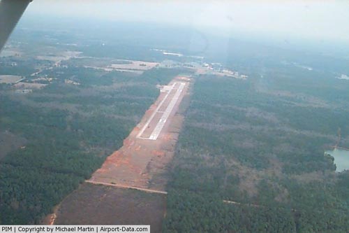 |
(Click on the photo to enlarge) |
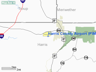
Location
& QuickFacts
|
FAA Information Effective: |
2007-07-05 |
|
Airport
Identifier: |
PIM |
|
Airport
Status: |
Operational |
|
Longitude/Latitude: |
084-52-56.8000W/32-50-26.5000N
-84.882444/32.840694 (Estimated) |
|
Elevation: |
902 ft / 274.93 m (Surveyed) |
|
Land: |
141 acres |
|
From
nearest city: |
2 nautical miles SW of Pine Mountain, GA |
|
Location: |
Harris County, GA |
|
Magnetic Variation: |
03W (2000) |
Owner
& Manager
|
Ownership: |
Publicly owned |
|
Owner: |
Harris County Attn: Carol Silva |
|
Address: |
County Courthouse, 104 N. College Street
Hamilton, GA 31811 |
|
Phone
number: |
706-628-4958 |
|
Manager: |
Jesse Floyd |
|
Address: |
789 Sky Meadow Drive
Pine Mountain, GA 31822 |
|
Phone number: |
706-663-5055 |
Airport
Operations and Facilities
|
Airport Use: |
Open to public |
|
Wind
indicator: |
Yes |
|
Segmented
Circle: |
Yes |
|
Control
Tower: |
No |
|
Lighting
Schedule: |
DUSK-DAWN
ACTVT MIRL RY 09/27 & VASI RY 09 - CTAF. |
|
Beacon
Color: |
Clear-Green (lighted land airport) |
|
Landing
fee charge: |
No |
|
Sectional
chart: |
Atlanta |
|
Region: |
ASO - Southern |
|
Boundary
ARTCC: |
ZTL - Atlanta |
|
Tie-in
FSS: |
MCN - Macon |
|
FSS
on Airport: |
No |
|
FSS
Toll Free: |
1-800-WX-BRIEF |
|
NOTAMs
Facility: |
MCN (NOTAM-d service avaliable) |
|
Federal Agreements: |
NGY |
Airport
Communications
|
CTAF: |
122.800 |
|
Unicom: |
122.800 |
Airport
Services
|
Fuel available: |
100LLA1+ |
|
Airframe Repair: |
NONE |
|
Power Plant Repair: |
NONE |
|
Bottled
Oxygen: |
NONE |
|
Bulk
Oxygen: |
NONE |
|
Runway Information
Runway 09/27
|
Dimension: |
5002 x 100 ft / 1524.6 x 30.5 m |
|
Surface: |
ASPH, Fair Condition |
|
Weight
Limit: |
Single wheel: 20000 lbs. |
|
Edge
Lights: |
Medium |
|
|
Runway 09 |
Runway 27 |
|
Longitude: |
084-53-26.0711W |
084-52-27.4721W |
|
Latitude: |
32-50-25.8174N |
32-50-27.2056N |
|
Elevation: |
902.00 ft |
900.00 ft |
|
Alignment: |
88 |
127 |
|
Traffic
Pattern: |
Left |
Left |
|
Markings: |
Non-precision instrument, Fair Condition |
Non-precision instrument, Fair Condition |
|
Crossing
Height: |
31.00 ft |
0.00 ft |
|
VASI: |
4-box on right side |
|
|
Visual
Glide Angle: |
3.50° |
0.00° |
|
Obstruction: |
67 ft trees, 669.0 ft from runway, 300 ft right
of centerline, 7:1 slope to clear
TREELINE ACROSS APPROACH.
+12
FT TREES AND BRUSH AT THRESHOLD 180 FT RIGHT. |
47 ft trees, 811.0 ft from runway, 400 ft right
of centerline, 13:1 slope to clear
TREES 130' LEFT.
RY
27 RY 27 +6 TREES 60 FT FROM RY END 150 FT LEFT. |
|
Radio Navigation
Aids
|
ID |
Type |
Name |
Ch |
Freq |
Var |
Dist |
|
PIM |
NDB |
Pine Mountain |
|
272.00 |
03W |
0.5 nm |
|
EQQ |
NDB |
Coweta County |
|
234.00 |
03W |
26.4 nm |
|
AWS |
NDB |
Lawson |
|
335.00 |
02W |
33.7 nm |
|
FF |
NDB |
Pecat |
|
316.00 |
02W |
34.1 nm |
|
OP |
NDB |
Yates |
|
339.00 |
03W |
35.4 nm |
|
JHH |
NDB |
Griffin |
|
412.00 |
04W |
38.9 nm |
|
GPQ |
NDB |
Carrollton |
|
278.00 |
02W |
45.3 nm |
|
LSF |
VOR/DME |
Lawson |
051X |
111.40 |
02W |
31.1 nm |
|
TGE |
VOR/DME |
Tuskegee |
120X |
117.30 |
02E |
45.2 nm |
|
CSG |
VORTAC |
Columbus |
118X |
117.10 |
01E |
15.2 nm |
|
LGC |
VORTAC |
Lagrange |
103X |
115.60 |
01E |
20.6 nm |
Remarks
Based Aircraft
|
Aircraft
based on field: |
1 |
|
Single
Engine Airplanes: |
1 |
Operational Statistics
Time Period: 2005-06-23
- 2006-06-22
|
Aircraft
Operations: |
145/Week |
|
General
Aviation Local: |
20.0% |
|
General
Aviation Itinerant: |
80.0% |
Harris County Airport
Address:
Harris County, GA
Tel:
706-628-4958,
706-663-5055
Images
and information placed above are from
http://www.airport-data.com/airport/PIM/
We
thank them for the data!
| General
Info |
| Country |
United
States |
| State |
GEORGIA
|
| FAA ID |
PIM
|
| Time |
UTC-5(-4DT)
|
| Latitude |
32.840694
32° 50' 26.50" N |
| Longitude |
-84.882444
084° 52' 56.80" W |
| Elevation |
902 feet
275 meters |
| Magnetic
Variation |
003° W
(08/06) |
| Beacon |
Yes
|
| Operating
Agency |
U.S.CIVIL
AIRPORT WHEREIN PERMIT COVERS USE BY TRANSIT MILITARY AIRCRAFT
|
| Near City |
Pine Mountain
|
| Operating
Hours |
SEE REMARKS
FOR OPERATING HOURS OR COMMUNICATIONS FOR POSSIBLE HOURS |
| Daylight
Saving Time |
Second
Sunday in March at 0200 to first Sunday in November at 0200 local
time (Exception Arizona and that portion of Indiana in the Eastern
Time Zone) |
We don't guarantee the information is fresh and accurate. The data may
be wrong or outdated.
For more up-to-date information please refer to other sources.
|
|


