|
|
|
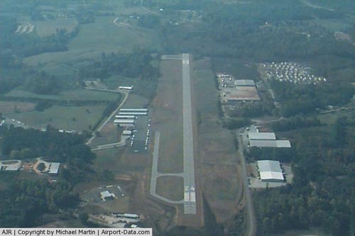 |
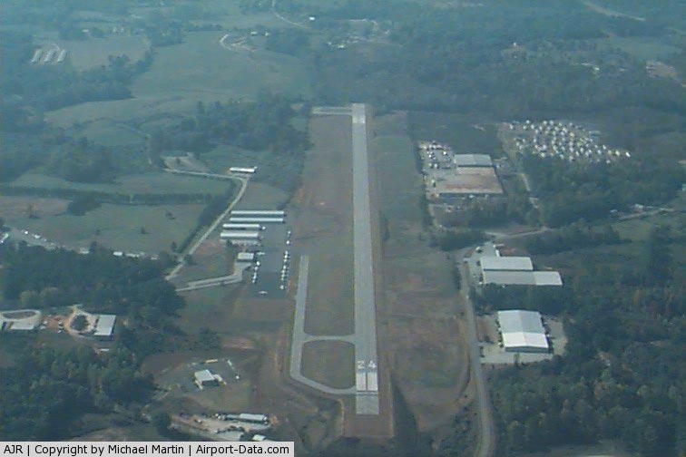
(Click on the photo to enlarge) |
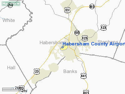
Location
& QuickFacts
|
FAA Information Effective: |
2007-01-18 |
|
Airport
Identifier: |
AJR |
|
Airport
Status: |
Operational |
|
Longitude/Latitude: |
083-33-24.0910W/34-29-59.6130N
-83.556692/34.499893 (Estimated) |
|
Elevation: |
1447 ft / 441.05 m (Surveyed) |
|
Land: |
133 acres |
|
From
nearest city: |
2 nautical miles SW of Cornelia, GA |
|
Location: |
Habersham County, GA |
|
Magnetic Variation: |
02W (1980) |
Owner
& Manager
|
Ownership: |
Publicly owned |
|
Owner: |
Habersham County |
|
Address: |
555 Monroe Street, Unit 20
Clarkesville, GA 30523 |
|
Phone number: |
706-754-6264 |
|
Manager: |
Jim Tatum Fbo |
|
Address: |
1112 Airport Road
Cornelia, GA 30531 |
|
Phone number: |
706-778-9978 |
Airport
Operations and Facilities
|
Airport Use: |
Open to public |
|
Wind
indicator: |
Yes |
|
Segmented
Circle: |
Yes |
|
Control
Tower: |
No |
|
Lighting
Schedule: |
DUSK-DAWN
MIRL RY 06/24 PRESET ON LOW INTST DUSK-2200; TO INCR INTST
- CTAF.
AFT 2200 ACTVT - CTAF. |
|
Beacon
Color: |
Clear-Green (lighted land airport) |
|
Landing
fee charge: |
No |
|
Sectional
chart: |
Atlanta |
|
Region: |
ASO - Southern |
|
Boundary
ARTCC: |
ZTL - Atlanta |
|
Tie-in
FSS: |
MCN - Macon |
|
FSS
on Airport: |
No |
|
FSS
Phone: |
478-784-1155 |
|
FSS
Toll Free: |
1-800-WX-BRIEF |
|
NOTAMs
Facility: |
MCN (NOTAM-d service avaliable) |
|
Federal Agreements: |
NGY |
Airport
Communications
|
CTAF: |
122.700 |
|
Unicom: |
122.700 |
Airport
Services
|
Fuel available: |
100LL |
|
Airframe Repair: |
MINOR |
|
Power Plant Repair: |
MINOR |
|
Bottled
Oxygen: |
NONE |
|
Bulk
Oxygen: |
NONE |
|
Runway Information
Runway 06/24
|
Dimension: |
5500 x 100 ft / 1676.4 x 30.5 m |
|
Surface: |
ASPH, Good Condition |
|
Weight
Limit: |
Single wheel: 30000 lbs. |
|
Edge
Lights: |
Medium |
|
|
Runway 06 |
Runway 24 |
|
Longitude: |
083-33-51.7431W |
083-32-56.4384W |
|
Latitude: |
34-29-44.9188N |
34-30-14.3071N |
|
Elevation: |
1403.00
ft |
1447.00
ft |
|
Alignment: |
57 |
127 |
|
Traffic
Pattern: |
Left |
Left |
|
Markings: |
Non-precision instrument, Good Condition |
Non-precision instrument, Good Condition |
|
Crossing
Height: |
45.00
ft |
40.00
ft |
|
Displaced
threshold: |
1390.00
ft |
0.00 ft |
|
VASI: |
2-light PAPI on left side |
2-light PAPI on left side |
|
Visual
Glide Angle: |
3.25° |
3.50° |
|
Obstruction: |
61 ft trees, 627.0 ft from runway, 200 ft left
of centerline, 7:1 slope to clear
TREELINE ACROSS APCH.
RWY 06 APCH RATIO 28:1 TO DSPLCD THLD. 63 FT TREES 1964 FT
FROM DSPLCD THLD & 600 FT LEFT. |
74 ft trees, 2272.0 ft from runway, 28:1 slope
to clear
TREES 250' LEFT.
+ 10 FT TREES AND BRUSH 60 FEET OUT FROM RWY END AND 100 FEET
RIGHT, AND +15 FT TREES AND BRUSH 10 FEET OUT FROM RWY END
AND 75 TO 175 FEET LEFT. |
|
Radio Navigation
Aids
|
ID |
Type |
Name |
Ch |
Freq |
Var |
Dist |
|
AJR |
NDB |
Habersham |
|
347.00 |
03W |
0.4 nm |
|
FKV |
NDB |
Flowery Branch |
|
365.00 |
03W |
24.9 nm |
|
DDA |
NDB |
Commerce |
|
244.00 |
03W |
26.4 nm |
|
BMW |
NDB |
Barrow County |
|
404.00 |
03W |
34.0 nm |
|
CEU |
NDB |
Clemson |
|
257.00 |
05W |
34.8 nm |
|
BJT |
NDB |
Bulldog |
|
221.00 |
03W |
37.0 nm |
|
TTQ |
NDB |
Tomotla |
|
335.00 |
01W |
42.0 nm |
|
AND |
NDB |
Anderson County |
|
230.00 |
04W |
42.0 nm |
|
JZP |
NDB |
Pickens County |
|
285.00 |
04W |
44.8 nm |
|
LQK |
NDB |
Lake Keowee |
|
408.00 |
04W |
46.1 nm |
|
JNM |
NDB |
Monroe |
|
392.00 |
03W |
46.6 nm |
|
DJD |
NDB |
Canton |
|
415.00 |
04W |
48.5 nm |
|
ODF |
VORTAC |
Foothills |
081X |
113.40 |
00E |
17.4 nm |
|
HRS |
VORTAC |
Harris |
035X |
109.80 |
00E |
32.0 nm |
|
AHN |
VORTAC |
Athens |
33 |
109.60 |
00E |
35.1 nm |
|
ELW |
VORTAC |
Electric City |
023X |
108.60 |
00E |
38.6 nm |
Based
Aircraft
|
Aircraft
based on field: |
65 |
|
Single
Engine Airplanes: |
54 |
|
Multi
Engine Airplanes: |
10 |
|
Helicopters: |
1 |
Operational Statistics
Time Period: 2004-08-06
- 2005-08-05
|
Aircraft
Operations: |
58/Day |
|
General
Aviation Local: |
61.9% |
|
General
Aviation Itinerant: |
38.1% |
Habersham County Airport
Address:
Habersham County, GA
Tel:
706-754-6264, 706-778-9978
Images
and information placed above are from
http://www.airport-data.com/airport/AJR/
We
thank them for the data!
| General
Info |
| Country |
United
States |
| State |
GEORGIA
|
| FAA ID |
AJR
|
| Latitude |
34-30-02.950N
|
| Longitude |
083-33-17.532W
|
| Elevation |
1448 feet
|
| Near City |
CORNELIA
|
We don't guarantee the information is fresh and accurate. The data may
be wrong or outdated.
For more up-to-date information please refer to other sources.
|
|