 |
|
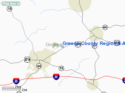
Greene County Regional Airport |
| Greene County Regional Airport |
| IATA: none â ICAO: none â FAA LID: 3J7 |
| Summary |
| Airport type |
Public |
| Owner |
Greene County |
| Location |
Greensboro, Georgia |
| Elevation AMSL |
677 ft / 206 m |
| Coordinates |
33°35â²52â³N 083°08â²20â³W / 33.59778°N 83.13889°W / 33.59778; -83.13889 |
| Runways |
| Direction |
Length |
Surface |
| ft |
m |
| 6/24 |
5,004 |
1,525 |
Asphalt |
| Statistics (2007) |
| Aircraft operations |
9,950 |
| Based aircraft |
25 |
| Source: Federal Aviation Administration |
Greene County Regional Airport (FAA LID: 3J7) is a county-owned public-use airport located three nautical miles (6 km) northeast of the central business district of Greensboro, a city in Greene County, Georgia, United States. As per the FAA's National Plan of Integrated Airport Systems for 2009-2013, it is classified as a general aviation airport.
Facilities and aircraft
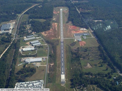
Greene County Regional Airport covers an area of 200 acres (81 ha) at an elevation of 677 feet (206 m) above mean sea level. It has one runway designated 6/24 with a 5,004 by 75 ft (1,525 x 23 m) asphalt surface.
For the 12-month period ending August 2, 2007, the airport had 9,950 aircraft operations, an average of 27 per day: 95% general aviation and 5% military. At that time there were 25 aircraft based at this airport: 64% single-engine, 20% multi-engine and 16% jet.
The above content comes from Wikipedia and is published under free licenses – click here to read more.
|
 |
(Click on the photo to enlarge) |
Location
& QuickFacts
|
FAA Information Effective: |
2007-01-18 |
|
Airport
Identifier: |
3J7 |
|
Airport
Status: |
Operational |
|
Longitude/Latitude: |
083-08-20.4000W/33-35-51.6000N
-83.139000/33.597667 (Estimated) |
|
Elevation: |
677 ft / 206.35 m (Surveyed) |
|
Land: |
156 acres |
|
From
nearest city: |
3 nautical miles NE of Greensboro, GA |
|
Location: |
Greene County, GA |
|
Magnetic Variation: |
03W (1985) |
Owner
& Manager
|
Ownership: |
Publicly owned |
|
Owner: |
Greene County |
|
Address: |
County Courthouse
Greensboro, GA 30642 |
|
Phone
number: |
706-453-7716 |
|
Manager: |
Gerald Schnaedelbach
CHAIRMAN, GREENE COUNTY AIRPORT AUTHORITY. |
|
Address: |
1140 Tal Lewis Rd
White Plains, GA 30678 |
|
Phone number: |
706-467-2712 |
Airport
Operations and Facilities
|
Airport Use: |
Open to public |
|
Wind
indicator: |
Yes |
|
Segmented
Circle: |
Yes |
|
Control
Tower: |
No |
|
Lighting
Schedule: |
DUSK-DAWN
PAPI RY 06 & VASI RY 24 OPER CONT AND MIRL RY 06/24
PRESET MED INTST DUSK-DAWN; TO INCR INTST FOR MIRL RY 06/24,
PAPI RY 06 & VASI RY 24 - CTAF. |
|
Beacon
Color: |
Clear-Green (lighted land airport)
ROTG BCN OTS INDEFLY. |
|
Landing
fee charge: |
No |
|
Sectional
chart: |
Atlanta |
|
Region: |
ASO - Southern |
|
Boundary
ARTCC: |
ZTL - Atlanta |
|
Tie-in
FSS: |
MCN - Macon |
|
FSS
on Airport: |
No |
|
FSS
Phone: |
478-784-1155 |
|
FSS
Toll Free: |
1-800-WX-BRIEF |
|
NOTAMs
Facility: |
MCN (NOTAM-d service avaliable) |
|
Federal Agreements: |
NGY |
Airport
Communications
|
CTAF: |
122.800 |
|
Unicom: |
122.800 |
Airport
Services
|
Fuel available: |
100LLA
FUEL AVBL 24 HRS CALL 706-474-0060. |
|
Airframe Repair: |
MAJOR |
|
Power Plant Repair: |
MAJOR |
|
Bottled
Oxygen: |
NONE |
|
Bulk
Oxygen: |
NONE |
|
Runway Information
Runway 06/24
|
Dimension: |
5004 x 75 ft / 1525.2 x 22.9 m |
|
Surface: |
ASPH, Good Condition |
|
Weight
Limit: |
Single wheel: 33000 lbs.
Dual wheel: 50000 lbs.
Dual
tandem wheel: 80000 lbs. |
|
Edge
Lights: |
Medium |
|
|
Runway 06 |
Runway 24 |
|
Longitude: |
083-08-46.9852W |
083-07-53.7829W |
|
Latitude: |
33-35-40.8037N |
33-36-02.4344N |
|
Elevation: |
677.00
ft |
677.00
ft |
|
Alignment: |
64 |
127 |
|
ILS
Type: |
|
LOC/DME |
|
Traffic
Pattern: |
Left |
Left |
|
Markings: |
Non-precision instrument, Good Condition |
Non-precision instrument, Good Condition |
|
Crossing
Height: |
40.00
ft |
0.00 ft |
|
Displaced
threshold: |
100.00
ft |
0.00 ft |
|
VASI: |
2-light PAPI on left side |
2-box on left side |
|
Visual
Glide Angle: |
3.00° |
0.00° |
|
Obstruction: |
57 ft trees, 200.0 ft from runway, 260 ft right
of centerline
APCH RATIO 0:1 TO DSPLCD THLD. |
20 ft trees, 460.0 ft from runway, 270 ft left
of centerline, 13:1 slope to clear |
|
Radio Navigation
Aids
|
ID |
Type |
Name |
Ch |
Freq |
Var |
Dist |
|
VV |
NDB |
Junne |
|
353.00 |
05W |
6.6 nm |
|
IIY |
NDB |
Washington/wilkes County |
|
435.00 |
03W |
19.5 nm |
|
BJT |
NDB |
Bulldog |
|
221.00 |
03W |
21.6 nm |
|
AA |
NDB |
Cedar |
|
341.00 |
04W |
26.6 nm |
|
UMB |
NDB |
Culvr |
|
380.00 |
04W |
26.8 nm |
|
BMW |
NDB |
Barrow County |
|
404.00 |
03W |
30.3 nm |
|
JNM |
NDB |
Monroe |
|
392.00 |
03W |
30.6 nm |
|
HQU |
NDB |
Thomson-mcduffie |
|
333.00 |
04W |
31.5 nm |
|
VOF |
NDB |
Alcovy |
|
370.00 |
03W |
32.3 nm |
|
DDA |
NDB |
Commerce |
|
244.00 |
03W |
33.8 nm |
|
HIT |
NDB |
Kaolin |
|
360.00 |
05W |
36.3 nm |
|
AHN |
VORTAC |
Athens |
33 |
109.60 |
00E |
23.0 nm |
|
IRQ |
VORTAC |
Colliers |
086X |
113.90 |
04W |
49.3 nm |
Remarks
- GCO
AVBL ON FREQ 121.725 MACON FSS.
- VFR
USE ONLY.
Based
Aircraft
|
Aircraft
based on field: |
21 |
|
Single
Engine Airplanes: |
17 |
|
Multi
Engine Airplanes: |
4 |
Operational Statistics
Time Period: 2004-05-26
- 2005-05-25
|
Aircraft
Operations: |
192/Week |
|
General
Aviation Local: |
47.5% |
|
General
Aviation Itinerant: |
47.5% |
|
Military: |
5.0% |
Greene County Regional Airport
Address:
Greene County, GA
Tel:
706-453-7716,
706-467-2712
Images
and information placed above are from
http://www.airport-data.com/airport/3J7/
We
thank them for the data!
| General
Info |
| Country |
United
States |
| State |
GEORGIA
|
| FAA ID |
3J7
|
| Latitude |
33-35-51.600N
|
| Longitude |
083-08-20.400W
|
| Elevation |
677 feet
|
| Near City |
GREENSBORO
|
We don't guarantee the information is fresh and accurate. The data may
be wrong or outdated.
For more up-to-date information please refer to other sources.
|
|


