 |
|
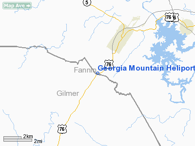
Georgia Mountain Heliport |
Location
& QuickFacts
|
FAA Information Effective: |
2007-01-18 |
|
Airport
Identifier: |
1GE1 |
|
Airport
Status: |
Operational |
|
Longitude/Latitude: |
084-21-17.0000W/34-49-41.0000N
-84.354722/34.828056 (Estimated) |
|
Elevation: |
1600 ft / 487.68 m (Estimated) |
|
Land: |
0
acres |
|
From
nearest city: |
0 nautical miles N of Blue Ridge, GA |
|
Location: |
Fannin County, GA |
|
Magnetic Variation: |
03W (1995) |
Owner
& Manager
|
Ownership: |
Privately owned |
|
Owner: |
Mar Enterprises
DBA GEORGIA MOUNTAIN HELICOPTER. |
|
Address: |
2391 Murdock Road
Marietta, GA 30062 |
|
Phone number: |
770-317-1063 |
|
Manager: |
Michael A. Russell |
|
Address: |
2391 Murdock Road
Marietta, GA 30062 |
|
Phone number: |
770-317-1063 |
Airport
Operations and Facilities
|
Airport Use: |
Private |
|
Wind
indicator: |
Yes |
|
Segmented
Circle: |
No |
|
Control
Tower: |
No |
|
Sectional
chart: |
Atlanta |
|
Region: |
ASO - Southern |
|
Boundary
ARTCC: |
ZTL - Atlanta |
|
Tie-in
FSS: |
MCN - Macon |
|
FSS
Phone: |
478-784-1155 |
|
FSS
Toll Free: |
1-800-WX-BRIEF |
|
Runway Information
Helipad H1
|
Dimension: |
200 x 200 ft / 61.0 x 61.0 m |
|
Surface: |
TURF, Good Condition |
|
|
Runway H1 |
Runway |
|
Traffic
Pattern: |
Left |
Left |
|
Radio Navigation
Aids
|
ID |
Type |
Name |
Ch |
Freq |
Var |
Dist |
|
JZP |
NDB |
Pickens County |
|
285.00 |
04W |
22.9 nm |
|
TTQ |
NDB |
Tomotla |
|
335.00 |
01W |
26.2 nm |
|
UWI |
NDB |
Whitfield |
|
400.00 |
03W |
29.3 nm |
|
HDI |
NDB |
Hardwick |
|
369.00 |
01W |
33.5 nm |
|
DJD |
NDB |
Canton |
|
415.00 |
04W |
35.2 nm |
|
MMI |
NDB |
Mc Minn County |
|
242.00 |
03W |
35.5 nm |
|
OUK |
NDB |
Calhoun |
|
323.00 |
02W |
38.2 nm |
|
MNV |
NDB |
Madisonville |
|
361.00 |
04W |
43.1 nm |
|
FKV |
NDB |
Flowery Branch |
|
365.00 |
03W |
43.6 nm |
|
AJR |
NDB |
Habersham |
|
347.00 |
03W |
44.4 nm |
|
CQN |
NDB |
Daisy |
|
341.00 |
02W |
44.5 nm |
|
EVZ |
NDB |
Cartersville |
|
308.00 |
04W |
44.9 nm |
|
DTE |
NDB |
Mark Anton |
|
394.00 |
02W |
48.4 nm |
|
HRS |
VORTAC |
Harris |
035X |
109.80 |
00E |
22.7 nm |
|
GQO |
VORTAC |
Choo Choo |
105X |
115.80 |
01E |
40.2 nm |
Remarks
- 40
FT TREES 50 FT WEST, 12 FT POWER LINES 50 FT SOUTH, 25 FT SIGN 75 FT
NE, 150 FT TREES 250 FT NORTHEAST, 200 FT TREES 200 FT WEST.
- PRVDD
VFR/PVT USE, APCH/DEP FROM 130-150 DEGS, TKOF/LNDG AREA MKD, FLT OPNS
NOT REC WHEN TAILWIND EXCEEDS 15 KNOTS, WIND INDICATOR MAINTAINED, POWER
LINES NORTH & SOUTH OF HELIPORT MKD & LGTD.
Based
Aircraft
|
Aircraft
based on field: |
1 |
|
Helicopters: |
1 |
Georgia Mountain Heliport
Address:
Fannin County, GA
Tel:
770-317-1063
Images
and information placed above are from
http://www.airport-data.com/airport/1GE1/
We
thank them for the data!
| General
Info |
| Country |
United
States |
| State |
GEORGIA
|
| FAA ID |
1GE1
|
| Latitude |
34-49-41.000N
|
| Longitude |
084-21-17.000W
|
| Elevation |
1600 feet
|
| Near City |
BLUE RIDGE
|
We don't guarantee the information is fresh and accurate. The data may
be wrong or outdated.
For more up-to-date information please refer to other sources.
|
|


