 |
|
Fulton County Airport - Brown Field Airport |
Fulton County Airport
Charlie Brown Field |
 |
| IATA: FTY â ICAO: KFTY |
| Summary |
| Airport type |
Public |
| Operator |
Fulton County |
| Location |
Atlanta, Georgia |
| Elevation AMSL |
841 ft / 256.3 m |
| Runways |
| Direction |
Length |
Surface |
| ft |
m |
| 8/26 |
5,796 |
1,767 |
Asphalt |
| 14/32 |
4,157 |
1,267 |
Asphalt |
| 9/27 |
2,801 |
854 |
Asphalt |
For other airports with this name, see Fulton County Airport (disambiguation).
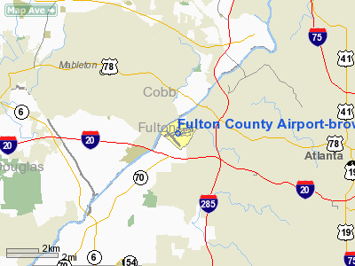
Fulton County Airport at Charlie Brown Field (IATA: FTY, ICAO: KFTY) is a local Class D airport located just west of Atlanta, and run by Fulton County of the U.S. state of Georgia. It is the nearest airport to Hartsfield-Jackson Atlanta International Airport (which is just south of Atlanta), and handles much of the general aviation traffic that would otherwise go there. The airport exists below and in close proximity to ATL's Class B airspace.
It is located very near Interstate 20, Interstate 285, and the Chattahoochee River, just outside the Atlanta city limits. It reports ASOS weather conditions 24 hours per day as West Atlanta. It also acted as the nearest backup weather station when Dobbins Air Reserve Base did not report overnight.
Its name comes not from Charlie Brown, the principal character in the comic strip Peanuts by Charles M. Schulz, but from the nickname for former Atlanta politician Charles M. Brown, who served on the city council and county commission during the 1960s. It is also called Charlie Brown Airport or Brown Field (not to be mistaken for the word "brownfield"). On the radio, however, it is referred to as "County Tower" or "County Ground".
The above content comes from Wikipedia and is published under free licenses – click here to read more.
|
 |
(Click on the photo to enlarge) |
Location
& QuickFacts
|
FAA Information Effective: |
2007-01-18 |
|
Airport
Identifier: |
FTY |
|
Airport
Status: |
Operational |
|
Longitude/Latitude: |
084-31-16.9000W/33-46-44.9000N
-84.521361/33.779139 (Estimated) |
|
Elevation: |
841 ft / 256.34 m (Surveyed) |
|
Land: |
985 acres |
|
From
nearest city: |
6 nautical miles W of Atlanta, GA |
|
Location: |
Fulton County, GA |
|
Magnetic Variation: |
02W (1985) |
Owner
& Manager
|
Ownership: |
Publicly owned |
|
Owner: |
Fulton County |
|
Address: |
County Courthouse
Atlanta, GA 30303 |
|
Phone
number: |
404-699-4200 |
|
Manager: |
Doug Barrett |
|
Address: |
3952 Aviation Circle Nw
Atlanta, GA 30336 |
|
Phone number: |
404-699-4200 |
Airport
Operations and Facilities
|
Airport Use: |
Open to public |
|
Wind
indicator: |
Yes |
|
Segmented
Circle: |
Yes |
|
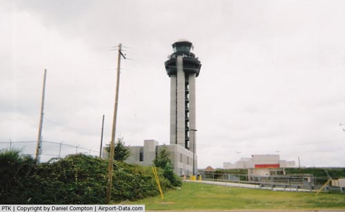
Control
Tower: |
Yes |
|
Lighting
Schedule: |
DUSK-DAWN
AFT 0200 ACTVT HIRL RY 08/26 AND MALSR RY 08 - CTAF. |
|
Beacon
Color: |
Clear-Green (lighted land airport) |
|
Landing
fee charge: |
No |
|
Sectional
chart: |
Atlanta |
|
Region: |
ASO - Southern |
|
Boundary
ARTCC: |
ZTL - Atlanta |
|
Tie-in
FSS: |
MCN - Macon |
|
FSS
on Airport: |
No |
|
FSS
Phone: |
478-784-1155 |
|
FSS
Toll Free: |
1-800-WX-BRIEF |
|
NOTAMs
Facility: |
FTY (NOTAM-d service avaliable) |
|
Federal Agreements: |
NGY |
Airport
Communications
|
CTAF: |
118.500 |
|
Unicom: |
122.950 |
Airport
Services
|
Fuel available: |
100LLA1+ |
|
Airframe Repair: |
MAJOR |
|
Power Plant Repair: |
MAJOR |
|
Bottled
Oxygen: |
HIGH/LOW |
|
Bulk
Oxygen: |
HIGH/LOW |
|
Runway Information
Runway 08/26
|
Dimension: |
5796 x 100 ft / 1766.6 x 30.5 m |
|
Surface: |
ASPH, Good Condition |
|
Surface
Treatment: |
Saw-cut or plastic Grooved |
|
Weight
Limit: |
Single wheel: 105000 lbs.
Dual wheel: 121000 lbs.
Dual
tandem wheel: 198000 lbs. |
|
Edge
Lights: |
High |
|
|
Runway 08 |
Runway 26 |
|
Longitude: |
084-31-48.3310W |
084-30-40.7792W |
|
Latitude: |
33-46-43.2909N |
33-46-53.5513N |
|
Elevation: |
800.00
ft |
814.00
ft |
|
Alignment: |
80 |
127 |
|
ILS
Type: |
ILS |
|
|
Traffic
Pattern: |
Left |
Right |
|
Markings: |
Precision instrument, Good Condition |
Precision instrument, Good Condition |
|
Crossing
Height: |
0.00 ft |
52.00
ft |
|
VASI: |
|
4-box on left side |
|
Visual
Glide Angle: |
0.00° |
3.00° |
|
Approach
lights: |
MALSR |
|
|
Runway
End Identifier: |
|
Yes |
|
Obstruction: |
25 ft trees, 475.0 ft from runway, 540 ft left
of centerline, 11:1 slope to clear
+8 FT TREES AND BRUSH 199 FT L OF THLD. |
19 ft trees, 732.0 ft from runway, 325 ft right
of centerline, 28:1 slope to clear |
|
Runway 09/27
|
Dimension: |
2801 x 60 ft / 853.7 x 18.3 m |
|
Surface: |
ASPH, Fair Condition |
|
Weight
Limit: |
Single wheel: 35000 lbs.
Dual wheel: 45000 lbs.
Dual
tandem wheel: 72000 lbs. |
|
|
Runway 09 |
Runway 27 |
|
Longitude: |
084-31-21.8171W |
084-30-49.1704W |
|
Latitude: |
33-46-51.3228N |
33-46-56.3050N |
|
Elevation: |
802.00
ft |
810.00
ft |
|
Alignment: |
80 |
127 |
|
Traffic
Pattern: |
Left |
Right |
|
Markings: |
Basic, Good Condition |
Basic, Good Condition |
|
Obstruction: |
32 ft trees, 680.0 ft from runway, 160 ft right
of centerline, 15:1 slope to clear |
50 ft trees, 200.0 ft from runway, 125 ft right
of centerline
+6 FT TREES & BRUSH AT 81 FT RIGHT OF THLD. |
|
Runway 14/32
|
Dimension: |
4157 x 100 ft / 1267.1 x 30.5 m |
|
Surface: |
ASPH, Fair Condition |
|
Weight
Limit: |
Single wheel: 30000 lbs. |
|
Edge
Lights: |
Medium |
|
|
Runway 14 |
Runway 32 |
|
Longitude: |
084-31-44.1219W |
084-31-11.7170W |
|
Latitude: |
33-46-49.3153N |
33-46-18.3550N |
|
Elevation: |
799.00
ft |
841.00
ft |
|
Alignment: |
127 |
127 |
|
Traffic
Pattern: |
Left |
Left |
|
Markings: |
Basic, Fair Condition |
Basic, Fair Condition |
|
Crossing
Height: |
52.00
ft |
0.00 ft |
|
Displaced
threshold: |
0.00 ft |
199.00
ft |
|
VASI: |
2-light PAPI on left side |
|
|
Visual
Glide Angle: |
4.00° |
0.00° |
|
Runway
End Identifier: |
Yes |
No |
|
Obstruction: |
23 ft trees, 706.0 ft from runway, 140 ft left
of centerline, 22:1 slope to clear
+10 FT BRUSH ACROSS APCH CRS 175 FT FM RY END. |
105 ft trees, 1565.0 ft from runway, 180 ft
right of centerline, 13:1 slope to clear
APCH RATIO 20:1 TO DSPLCD THLD. 88 FT TREES 1760 FT FM DSPLCD
THLD, 175 FT RIGHT. |
|
Radio Navigation
Aids
|
ID |
Type |
Name |
Ch |
Freq |
Var |
Dist |
|
FT |
NDB |
Flanc |
|
344.00 |
02W |
6.0 nm |
|
BR |
NDB |
Redan |
|
266.00 |
02W |
13.2 nm |
|
DJD |
NDB |
Canton |
|
415.00 |
04W |
28.5 nm |
|
FF |
NDB |
Pecat |
|
316.00 |
02W |
28.8 nm |
|
EVZ |
NDB |
Cartersville |
|
308.00 |
04W |
29.9 nm |
|
EQQ |
NDB |
Coweta County |
|
234.00 |
03W |
32.8 nm |
|
GPQ |
NDB |
Carrollton |
|
278.00 |
02W |
33.1 nm |
|
VOF |
NDB |
Alcovy |
|
370.00 |
03W |
38.0 nm |
|
JHH |
NDB |
Griffin |
|
412.00 |
04W |
38.7 nm |
|
JNM |
NDB |
Monroe |
|
392.00 |
03W |
39.8 nm |
|
FKV |
NDB |
Flowery Branch |
|
365.00 |
03W |
39.9 nm |
|
JZP |
NDB |
Pickens County |
|
285.00 |
04W |
40.8 nm |
|
OUK |
NDB |
Calhoun |
|
323.00 |
02W |
42.5 nm |
|
OYD |
NDB |
Floyd |
|
388.00 |
02W |
44.7 nm |
|
BMW |
NDB |
Barrow County |
|
404.00 |
03W |
47.5 nm |
|
DOB |
TACAN |
Dobbins |
077X |
|
01W |
8.2 nm |
|
PDK |
VOR/DME |
Peachtree |
113X |
116.60 |
02W |
12.5 nm |
|
ATL |
VORTAC |
Atlanta |
116X |
116.90 |
00W |
10.0 nm |
|
RMG |
VORTAC |
Rome |
101X |
115.40 |
01E |
37.7 nm |
|
ATL |
VOT |
Atlanta Muni |
|
111.00 |
|
8.7 nm |
Remarks
- FLOCKS
OF BIRDS ON AND INVOF ARPT DURING DALGT HRS.
- NOISE
SENSITIVE AREA ALL QUADRANTS; NO RUN UPS AUTHORIZED ON ANY RAMPS.
- DEER
AND OTHER WILDLIFE ON & INVOF ARPT.
- EXISTED
PRIOR TO 1959.
Based
Aircraft
|
Aircraft
based on field: |
174 |
|
Single
Engine Airplanes: |
74 |
|
Multi
Engine Airplanes: |
40 |
|
Jet Engine
Airplanes: |
57 |
|
Helicopters: |
3 |
Operational Statistics
Time Period: 2005-07-27
- 2006-07-26
|
Aircraft
Operations: |
359/Day |
|
Air Taxi: |
12.5% |
|
General
Aviation Local: |
30.0% |
|
General
Aviation Itinerant: |
57.4% |
|
Military: |
0.1% |
Fulton County Airport-brown Field Airport
Address:
Fulton County, GA
Tel:
404-699-4200
Images
and information placed above are from
http://www.airport-data.com/airport/FTY/
We
thank them for the data!
| General
Info |
| Country |
United
States |
| State |
GEORGIA
|
| FAA ID |
FTY
|
| Latitude |
33-46-44.900N
|
| Longitude |
084-31-16.900W
|
| Elevation |
841 feet
|
| Near City |
ATLANTA
|
We don't guarantee the information is fresh and accurate. The data may
be wrong or outdated.
For more up-to-date information please refer to other sources.
|
|


