 |
|
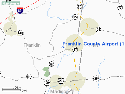
| Franklin County Airport |
| IATA: none â ICAO: none â FAA LID: 18A |
| Summary |
| Airport type |
Public |
| Owner |
Franklin County |
| Location |
Canon, Georgia |
| Elevation AMSL |
860 ft / 262 m |
| Coordinates |
34°20â²23â³N 083°07â²59â³W / 34.33972°N 83.13306°W / 34.33972; -83.13306 |
| Runways |
| Direction |
Length |
Surface |
| ft |
m |
| 8/26 |
3,513 |
1,071 |
Asphalt |
| Statistics (2006) |
| Aircraft operations |
6,000 |
| Source: Federal Aviation Administration |
Franklin County Airport (FAA LID: 18A) is a public airport located one mile (2 km) southwest of the central business district of Canon, a city in Franklin County, Georgia, United States. It is owned by Franklin County.
Facilities and aircraft
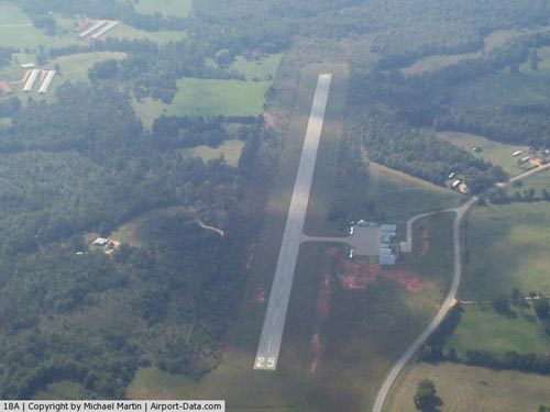
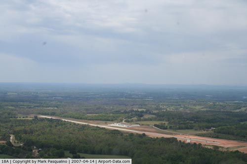
Franklin County Airport covers an area of 114 acres (46 ha) which contains one Asphalt paved runway (8/26) measuring 3,513 x 75 ft (1,071 x 23 m). For the 12-month period ending August 9, 2006, the airport had 6,000 aircraft operations, 100% of which were general aviation.
The above content comes from Wikipedia and is published under free licenses – click here to read more.
|
 |
(Click on the photo to enlarge) |
|
 |
(Click on the photo to enlarge) |
|
 |
(Click on the photo to enlarge) |
Location
& QuickFacts
|
FAA Information Effective: |
2007-01-18 |
|
Airport
Identifier: |
18A |
|
Airport
Status: |
Operational |
|
Longitude/Latitude: |
083-08-00.5400W/34-20-24.3770N
-83.133483/34.340105 (Estimated) |
|
Elevation: |
860 ft / 262.13 m (Estimated) |
|
Land: |
114 acres |
|
From
nearest city: |
1 nautical miles SW of Canon, GA |
|
Location: |
Franklin County, GA |
|
Magnetic Variation: |
05W (1985) |
Owner
& Manager
|
Ownership: |
Publicly owned |
|
Owner: |
Franklin County |
|
Address: |
Po Box 655
Royston, GA 30662 |
|
Phone number: |
706-384-2483 |
|
Manager: |
Harris Little |
|
Address: |
Po Box 655
Royston, GA 30662 |
|
Phone number: |
706-491-8790
ARPT PHONE 706-245-1002. |
Airport
Operations and Facilities
|
Airport Use: |
Open to public |
|
Wind
indicator: |
Yes |
|
Segmented
Circle: |
Yes |
|
Control
Tower: |
No |
|
Lighting
Schedule: |
DUSK-DAWN |
|
Beacon
Color: |
Clear-Green (lighted land airport) |
|
Landing
fee charge: |
No |
|
Sectional
chart: |
Atlanta |
|
Region: |
ASO - Southern |
|
Boundary
ARTCC: |
ZTL - Atlanta |
|
Tie-in
FSS: |
MCN - Macon |
|
FSS
on Airport: |
No |
|
FSS
Phone: |
478-784-1155 |
|
FSS
Toll Free: |
1-800-WX-BRIEF |
|
NOTAMs
Facility: |
MCN (NOTAM-d service avaliable) |
|
Federal Agreements: |
NY1 |
Airport
Communications
Airport
Services
|
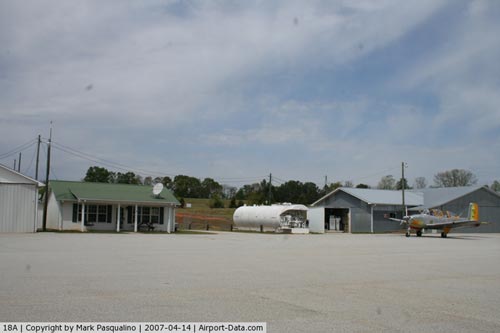
Fuel available: |
100LL |
|
Airframe Repair: |
NONE |
|
Power Plant Repair: |
NONE |
|
Bottled
Oxygen: |
NONE |
|
Bulk
Oxygen: |
NONE |
|
Runway Information
Runway 08/26
|
Dimension: |
3513 x 75 ft / 1070.8 x 22.9 m |
|
Surface: |
ASPH, Fair Condition |
|
Weight
Limit: |
Single wheel: 15000 lbs. |
|
Edge
Lights: |
Medium |
|
|
Runway 08 |
Runway 26 |
|
Longitude: |
083-08-19.2930W |
083-07-39.4290W |
|
Latitude: |
34-20-17.6610N |
34-20-28.3280N |
|
Elevation: |
828.00
ft |
860.00
ft |
|
Traffic
Pattern: |
Left |
Left |
|
Markings: |
Basic, Good Condition |
Basic, Good Condition |
|
Crossing
Height: |
26.00
ft |
29.00
ft |
|
VASI: |
2-light PAPI on left side |
2-light PAPI on left side |
|
Visual
Glide Angle: |
3.25° |
4.00° |
|
Obstruction: |
, 50:1 slope to clear
TREES 125' RIGHT. |
56 ft trees, 1208.0 ft from runway, 150 ft
left of centerline, 18:1 slope to clear
TREES 125' RIGHT. |
|
Radio Navigation
Aids
|
ID |
Type |
Name |
Ch |
Freq |
Var |
Dist |
|
AJR |
NDB |
Habersham |
|
347.00 |
03W |
22.8 nm |
|
AND |
NDB |
Anderson County |
|
230.00 |
04W |
23.1 nm |
|
CEU |
NDB |
Clemson |
|
257.00 |
05W |
23.5 nm |
|
BJT |
NDB |
Bulldog |
|
221.00 |
03W |
23.7 nm |
|
DDA |
NDB |
Commerce |
|
244.00 |
03W |
25.5 nm |
|
BMW |
NDB |
Barrow County |
|
404.00 |
03W |
33.3 nm |
|
LQK |
NDB |
Lake Keowee |
|
408.00 |
04W |
35.4 nm |
|
IIY |
NDB |
Washington/wilkes County |
|
435.00 |
03W |
37.5 nm |
|
FKV |
NDB |
Flowery Branch |
|
365.00 |
03W |
39.3 nm |
|
GY |
NDB |
Dyana |
|
338.00 |
03W |
40.2 nm |
|
VV |
NDB |
Junne |
|
353.00 |
05W |
42.1 nm |
|
JNM |
NDB |
Monroe |
|
392.00 |
03W |
46.7 nm |
|
ELW |
VORTAC |
Electric City |
023X |
108.60 |
00E |
17.9 nm |
|
ODF |
VORTAC |
Foothills |
081X |
113.40 |
00E |
22.9 nm |
|
AHN |
VORTAC |
Athens |
33 |
109.60 |
00E |
25.4 nm |
|
GRD |
VORTAC |
Greenwood |
102X |
115.50 |
01W |
48.9 nm |
Remarks
Based
Aircraft
|
Aircraft
based on field: |
19 |
|
Single
Engine Airplanes: |
18 |
|
Multi
Engine Airplanes: |
1 |
Operational Statistics
Time Period: 2005-08-10
- 2006-08-09
|
Aircraft
Operations: |
116/Week |
|
General
Aviation Local: |
50.0% |
|
General
Aviation Itinerant: |
50.0% |
Franklin County Airport
Address:
Franklin County, GA
Tel:
706-384-2483, 706-491-8790
Images
and information placed above are from
http://www.airport-data.com/airport/18A/
We
thank them for the data!
| General
Info |
| Country |
United
States |
| State |
GEORGIA
|
| FAA ID |
18A
|
| Latitude |
34-20-24.377N
|
| Longitude |
083-08-00.540W
|
| Elevation |
860 feet
|
| Near City |
CANON
|
We don't guarantee the information is fresh and accurate. The data may
be wrong or outdated.
For more up-to-date information please refer to other sources.
|
|


