 |
|
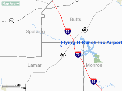
Flying H Ranch Incorporated Airport |
Location
& QuickFacts
|
FAA
Information Effective: |
2007-01-18 |
|
Airport
Identifier: |
GA01 |
|
Airport
Status: |
Operational |
|
Longitude/Latitude: |
084-05-04.0000W/33-11-52.0000N
-84.084444/33.197778 (Estimated) |
|
Elevation: |
722 ft / 220.07 m (Surveyed) |
|
Land: |
0 acres |
|
From
nearest city: |
9 nautical miles SW of Jackson, GA |
|
Location: |
Lamar County, GA |
|
Magnetic Variation: |
02W (1985) |
Owner
& Manager
|
Ownership: |
Privately
owned |
|
Owner: |
James Padgett |
|
Address: |
363 High Falls Road
Jackson, GA 30233 |
|
Phone number: |
404-228-4604 |
|
Address: |
|
Airport
Operations and Facilities
|
Airport Use: |
Private |
|
Wind indicator: |
Yes |
|
Segmented Circle: |
No |
|
Control Tower: |
No |
|
Landing fee charge: |
No |
|
Sectional chart: |
Atlanta |
|
Region: |
ASO - Southern |
|
Boundary ARTCC: |
ZTL - Atlanta |
|
Tie-in FSS: |
MCN - Macon |
|
FSS on Airport: |
No |
|
FSS Phone: |
478-784-1155 |
|
FSS Toll Free: |
1-800-WX-BRIEF |
Airport Services
|
Airframe
Repair: |
MAJOR |
|
Power
Plant Repair: |
MAJOR |
|
Runway Information
Runway 18/36
|
Dimension: |
2263
x 105 ft / 689.8 x 32.0 m |
|
Surface: |
TURF, |
|
|
Runway 18 |
Runway 36 |
|
Traffic
Pattern: |
Left |
Left |
|
Obstruction: |
20 ft plines, 100.0 ft from runway |
|
|
Radio
Navigation Aids
|
ID |
Type |
Name |
Ch |
Freq |
Var |
Dist |
|
JHH |
NDB |
Griffin |
|
412.00 |
04W |
7.2 nm |
|
OP |
NDB |
Yates |
|
339.00 |
03W |
17.5 nm |
|
FF |
NDB |
Pecat |
|
316.00 |
02W |
21.1 nm |
|
BR |
NDB |
Redan |
|
266.00 |
02W |
29.2 nm |
|
VOF |
NDB |
Alcovy |
|
370.00 |
03W |
30.1 nm |
|
EQQ |
NDB |
Coweta County |
|
234.00 |
03W |
31.8 nm |
|
JNM |
NDB |
Monroe |
|
392.00 |
03W |
37.1 nm |
|
FT |
NDB |
Flanc |
|
344.00 |
02W |
43.9 nm |
|
PIM |
NDB |
Pine Mountain |
|
272.00 |
03W |
45.1 nm |
|
UMB |
NDB |
Culvr |
|
380.00 |
04W |
46.6 nm |
|
BEP |
NDB |
Bay Creek |
|
350.00 |
03W |
47.3 nm |
|
DOB |
TACAN |
Dobbins |
077X |
|
01W |
48.0 nm |
|
PDK |
VOR/DME |
Peachtree |
113X |
116.60 |
02W |
42.1 nm |
|
ATL |
VORTAC |
Atlanta |
116X |
116.90 |
00W |
31.3 nm |
|
MCN |
VORTAC |
Macon |
089X |
114.20 |
01E |
37.6 nm |
|
ATL |
VOT |
Atlanta Muni |
|
111.00 |
|
32.5 nm |
Remarks
Flying H Ranch Incorporated Airport
Address:
Marion County, FL
Tel:
Images
and information placed above are from
http://www.airport-data.com/airport/GA01/
We
thank them for the data!
| General
Info |
| Country |
United
States |
| State |
GEORGIA
|
| FAA ID |
GA01 |
| Latitude |
33-11-52.000N
|
| Longitude |
084-05-04.000W
|
| Elevation |
722 feet
|
| Near City |
JACKSON
|
We don't guarantee the information is fresh and accurate. The data may
be wrong or outdated.
For more up-to-date information please refer to other sources.
|
|


