 |
|
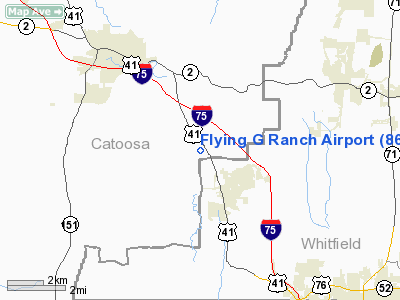
Location
& QuickFacts
|
FAA Information Effective: |
2007-01-18 |
|
Airport
Identifier: |
86GA |
|
Airport
Status: |
Operational |
|
Longitude/Latitude: |
085-03-39.8150W/34-52-04.2800N
-85.061060/34.867856 (Estimated) |
|
Elevation: |
845 ft / 257.56 m (Estimated) |
|
Land: |
0
acres |
|
From
nearest city: |
2 nautical miles NW of Tunnel Hill, GA |
|
Location: |
Catoosa County, GA |
|
Magnetic Variation: |
02W (1990) |
Owner
& Manager
|
Ownership: |
Privately owned |
|
Owner: |
Flying G Ranch |
|
Address: |
13106 Hwy 41
Tunnel Hill, GA 30755 |
|
Phone number: |
706-935-3122 |
|
Manager: |
Flying G Ranch |
|
Address: |
13106 Hwy 41
Tunnel Hill, GA 30755 |
|
Phone number: |
706-935-3122 |
Airport
Operations and Facilities
|
Airport Use: |
Private |
|
Segmented
Circle: |
No |
|
Control
Tower: |
No |
|
Sectional
chart: |
Atlanta |
|
Region: |
ASO - Southern |
|
Boundary
ARTCC: |
ZTL - Atlanta |
|
Tie-in
FSS: |
MCN - Macon |
|
FSS
on Airport: |
No |
|
FSS
Phone: |
478-784-1155 |
|
FSS
Toll Free: |
1-800-WX-BRIEF |
|
Runway Information
Runway 03/21
|
Dimension: |
2000 x 100 ft / 609.6 x 30.5 m |
|
Surface: |
TURF, |
|
|
Runway 03 |
Runway 21 |
|
Traffic
Pattern: |
Left |
Left |
|
Obstruction: |
100 ft trees, 760.0 ft from runway |
100 ft trees, 760.0 ft from runway |
|
Radio Navigation
Aids
|
ID |
Type |
Name |
Ch |
Freq |
Var |
Dist |
|
UWI |
NDB |
Whitfield |
|
400.00 |
03W |
7.4 nm |
|
CQN |
NDB |
Daisy |
|
341.00 |
02W |
18.6 nm |
|
HDI |
NDB |
Hardwick |
|
369.00 |
01W |
18.8 nm |
|
APT |
NDB |
Jasper |
|
382.00 |
02W |
28.2 nm |
|
OUK |
NDB |
Calhoun |
|
323.00 |
02W |
28.8 nm |
|
OYD |
NDB |
Floyd |
|
388.00 |
02W |
34.6 nm |
|
FTP |
NDB |
Fort Payne |
|
426.00 |
01W |
36.7 nm |
|
DTE |
NDB |
Mark Anton |
|
394.00 |
02W |
37.5 nm |
|
JZP |
NDB |
Pickens County |
|
285.00 |
04W |
38.7 nm |
|
MMI |
NDB |
Mc Minn County |
|
242.00 |
03W |
40.1 nm |
|
EVZ |
NDB |
Cartersville |
|
308.00 |
04W |
41.6 nm |
|
UOS |
NDB |
Sewanee |
|
275.00 |
02E |
45.8 nm |
|
DJD |
NDB |
Canton |
|
415.00 |
04W |
46.6 nm |
|
GQO |
VORTAC |
Choo Choo |
105X |
115.80 |
01E |
7.2 nm |
|
RMG |
VORTAC |
Rome |
101X |
115.40 |
01E |
42.5 nm |
Remarks
- LANDINGS
ON RY 03; TAKEOFFS RY 21.
- PRVDD
VFR/PR USE.
Based
Aircraft
|
Aircraft
based on field: |
7 |
|
Single
Engine Airplanes: |
6 |
|
Multi
Engine Airplanes: |
1 |
Flying G Ranch Airport
Address:
Catoosa County, GA
Tel:
706-935-3122
Images
and information placed above are from
http://www.airport-data.com/airport/86GA/
We
thank them for the data!
| General
Info |
| Country |
United
States |
| State |
GEORGIA
|
| FAA ID |
86GA
|
| Latitude |
34-52-04.280N
|
| Longitude |
085-03-39.815W
|
| Elevation |
845 feet
|
| Near City |
TUNNEL
HILL |
We don't guarantee the information is fresh and accurate. The data may
be wrong or outdated.
For more up-to-date information please refer to other sources.
|
|


