|
|
|
 |
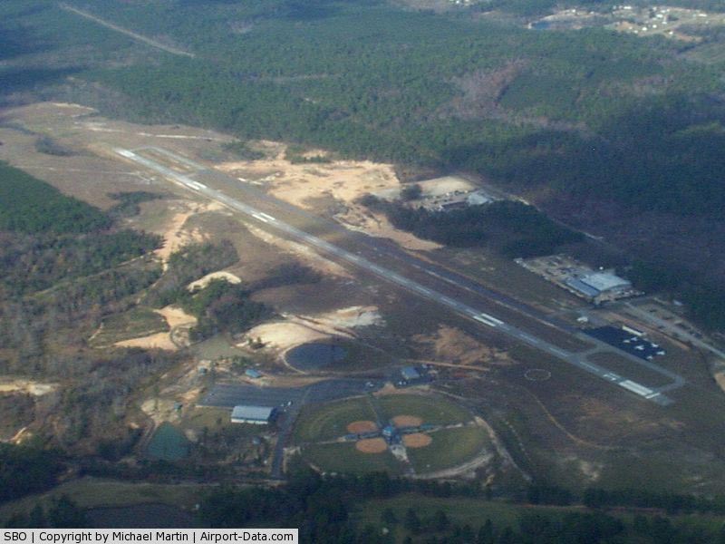
(Click on the photo to enlarge) |
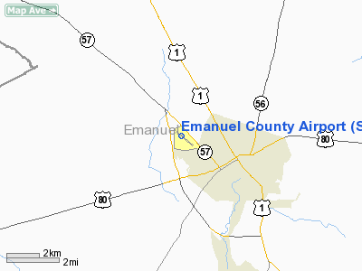
Location
& QuickFacts
|
FAA Information Effective: |
2007-01-18 |
|
Airport
Identifier: |
SBO |
|
Airport
Status: |
Operational |
|
Longitude/Latitude: |
082-22-11.8000W/32-36-32.9000N
-82.369944/32.609139 (Estimated) |
|
Elevation: |
327 ft / 99.67 m (Surveyed) |
|
Land: |
237 acres |
|
From
nearest city: |
2 nautical miles NW of Swainsboro, GA |
|
Location: |
Emanuel County, GA |
|
Magnetic Variation: |
04W (1990) |
Owner
& Manager
|
Ownership: |
Publicly owned |
|
Owner: |
Emanuel Co/swainsboro City |
|
Address: |
Box 600
Swainsboro, GA 30401 |
|
Phone number: |
478-237-7025 |
|
Manager: |
Roff Sasser |
|
Address: |
23 Airport Road
Swainsboro, GA 30401 |
|
Phone number: |
478-237-5883
ARPT PHONE 912-237-5882, FAX 478-982-3421. |
Airport
Operations and Facilities
|
Airport Use: |
Open to public |
|
Wind
indicator: |
Yes |
|
Segmented
Circle: |
Yes |
|
Control
Tower: |
No |
|
Lighting
Schedule: |
DUSK-DAWN
ACTVT PAPI RYS 13 & 31 - CTAF. ACTVT HIRL RY 13/31 1800-0900
ONLY - CTAF. |
|
Beacon
Color: |
Clear-Green (lighted land airport) |
|
Landing
fee charge: |
No |
|
Sectional
chart: |
Atlanta |
|
Region: |
ASO - Southern |
|
Boundary
ARTCC: |
ZTL - Atlanta |
|
Tie-in
FSS: |
MCN - Macon |
|
FSS
on Airport: |
No |
|
FSS
Phone: |
478-784-1155 |
|
FSS
Toll Free: |
1-800-WX-BRIEF |
|
NOTAMs
Facility: |
MCN (NOTAM-d service avaliable) |
|
Federal Agreements: |
NGY |
Airport
Communications
|
CTAF: |
122.975 |
|
Unicom: |
122.975 |
Airport
Services
|
Fuel available: |
100LLA
FOR AFT HRS FUEL - SELF SERVICE. |
|
Airframe Repair: |
MAJOR |
|
Power Plant Repair: |
MAJOR |
|
Bottled
Oxygen: |
NONE |
|
Bulk
Oxygen: |
NONE |
|
Runway Information
Runway 13/31
|
Dimension: |
6021 x 100 ft / 1835.2 x 30.5 m |
|
Surface: |
ASPH, Good Condition |
|
Weight
Limit: |
Single wheel: 30000 lbs. |
|
Edge
Lights: |
High |
|
|
Runway 13 |
Runway 31 |
|
Longitude: |
082-22-38.9454W |
082-21-44.6343W |
|
Latitude: |
32-36-51.8231N |
32-36-13.9286N |
|
Elevation: |
324.00
ft |
322.00
ft |
|
Alignment: |
127 |
127 |
|
ILS
Type: |
LOCALIZER |
|
|
Traffic
Pattern: |
Left |
Left |
|
Markings: |
Non-precision instrument, Good Condition |
Non-precision instrument, Good Condition |
|
VASI: |
4-light PAPI on left side
PAPI RY 13 OTS INDEFLY. |
4-light PAPI on left side |
|
Obstruction: |
24 ft trees, 800.0 ft from runway, 330 ft left
of centerline, 25:1 slope to clear |
49 ft trees, 1425.0 ft from runway, 410 ft
left of centerline, 25:1 slope to clear
SCRUB BRUSH AND TREES +7 FT ABOVE RY ELEVATION 91 FT FROM
RY END AND 260 FT LEFT OF RY CNTRLN. |
|
Radio Navigation
Aids
|
ID |
Type |
Name |
Ch |
Freq |
Var |
Dist |
|
EEX |
NDB |
Emanuel County |
|
309.00 |
04W |
5.4 nm |
|
MHP |
NDB |
Metter |
|
432.00 |
03W |
20.3 nm |
|
UQN |
NDB |
Onyun |
|
372.00 |
04W |
23.5 nm |
|
LNH |
NDB |
Millen |
|
205.00 |
05W |
26.6 nm |
|
BXG |
NDB |
Burke County |
|
356.00 |
04W |
31.9 nm |
|
DB |
NDB |
Creke |
|
251.00 |
04W |
33.3 nm |
|
RVJ |
NDB |
Prison |
|
424.00 |
03W |
34.9 nm |
|
CWV |
NDB |
Claxton |
|
395.50 |
04W |
35.1 nm |
|
BZ |
NDB |
Bullo |
|
407.00 |
05W |
37.6 nm |
|
HIT |
NDB |
Kaolin |
|
360.00 |
05W |
37.8 nm |
|
JYL |
NDB |
Sylvania |
|
245.00 |
04W |
39.3 nm |
|
MQW |
NDB |
Mc Rae |
|
280.00 |
03W |
40.5 nm |
|
AZE |
NDB |
Hazlehurst |
|
414.00 |
03W |
46.0 nm |
|
EZM |
NDB |
Eastman |
|
366.00 |
04W |
49.0 nm |
|
DBN |
VORTAC |
Dublin |
078X |
113.10 |
01W |
23.6 nm |
Remarks
- PAEW
N SIDE OF RY 13/31 INDEFLY.
- TWY
CLSD AER 31 TO TERMINAL RAMP INDEFLY.
- EXISTED
PRIOR TO 1959.
Based
Aircraft
|
Aircraft
based on field: |
14 |
|
Single
Engine Airplanes: |
7 |
|
Multi
Engine Airplanes: |
7 |
Operational Statistics
Time Period: 2004-03-31
- 2005-03-30
|
Aircraft
Operations: |
93/Week |
|
Air Taxi: |
16.7% |
|
General
Aviation Local: |
33.3% |
|
General
Aviation Itinerant: |
50.0% |
Emanuel County Airport
Address:
Emanuel County, GA
Tel:
478-237-7025, 478-237-5883
Images
and information placed above are from
http://www.airport-data.com/airport/SBO/
We
thank them for the data!
| General
Info |
| Country |
United
States |
| State |
GEORGIA
|
| FAA ID |
SBO
|
| Latitude |
32-36-29.673N
|
| Longitude |
082-22-07.189W
|
| Elevation |
328 feet
|
| Near City |
SWAINSBORO
|
We don't guarantee the information is fresh and accurate. The data may
be wrong or outdated.
For more up-to-date information please refer to other sources.
|
|