 |
|
Elbert County - Patz Field Airport |
|
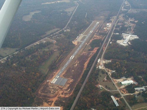 |
(Click on the photo to enlarge) |
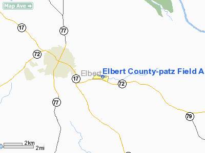
Location
& QuickFacts
|
FAA Information Effective: |
2007-01-18 |
|
Airport
Identifier: |
27A |
|
Airport
Status: |
Operational |
|
Longitude/Latitude: |
082-48-57.1110W/34-05-42.7100N
-82.815864/34.095197 (Estimated) |
|
Elevation: |
603 ft / 183.79 m (Surveyed) |
|
Land: |
48
acres |
|
From
nearest city: |
2 nautical miles E of Elberton, GA |
|
Location: |
Elbert County, GA |
|
Magnetic Variation: |
05W (2000) |
Owner
& Manager
|
Ownership: |
Publicly owned |
|
Owner: |
Elbert County |
|
Address: |
County Courthouse, 10 West Church Street
Elberton, GA 30635 |
|
Phone
number: |
706-283-2000 |
|
Manager: |
Randy Haralson, Fbo |
|
Address: |
1136 Von Trina Rd
Elberton, GA 30635 |
|
Phone number: |
706-283-2035 |
Airport
Operations and Facilities
|
Airport Use: |
Open to public |
|
Wind
indicator: |
Yes |
|
Segmented
Circle: |
Yes |
|
Control
Tower: |
No |
|
Lighting
Schedule: |
DUSK-DAWN
MIRL RY 10/28 OPER CTAF 24 HRS. PAPI
RYS 10 & 28 OPER CONT. |
|
Beacon
Color: |
Clear-Green (lighted land airport) |
|
Landing
fee charge: |
No |
|
Sectional
chart: |
Atlanta |
|
Region: |
ASO - Southern |
|
Boundary
ARTCC: |
ZTL - Atlanta |
|
Tie-in
FSS: |
MCN - Macon |
|
FSS
on Airport: |
No |
|
FSS
Phone: |
478-784-1155 |
|
FSS
Toll Free: |
1-800-WX-BRIEF |
|
NOTAMs
Facility: |
MCN (NOTAM-d service avaliable) |
|
Federal Agreements: |
NGY |
Airport
Communications
|
CTAF: |
122.800 |
|
Unicom: |
122.800 |
Airport
Services
|
Fuel available: |
100LLMOGAS |
|
Airframe Repair: |
NONE |
|
Power Plant Repair: |
NONE |
|
Bottled
Oxygen: |
NONE |
|
Bulk
Oxygen: |
NONE |
|
Runway Information
Runway 10/28
|
Dimension: |
4000 x 75 ft / 1219.2 x 22.9 m |
|
Surface: |
ASPH, Good Condition |
|
Weight
Limit: |
Single wheel: 30000 lbs. |
|
Edge
Lights: |
Medium |
|
|
Runway 10 |
Runway 28 |
|
Longitude: |
082-49-20.6150W |
082-48-33.6070W |
|
Latitude: |
34-05-45.7170N |
34-05-39.7030N |
|
Elevation: |
600.00
ft |
603.00
ft |
|
Alignment: |
99 |
127 |
|
Traffic
Pattern: |
Left |
Left |
|
Markings: |
Non-precision instrument, Good Condition |
Non-precision instrument, Good Condition |
|
Crossing
Height: |
42.00
ft |
39.00
ft |
|
VASI: |
2-light PAPI on left side |
2-light PAPI on left side |
|
Visual
Glide Angle: |
3.75° |
3.75° |
|
Obstruction: |
50 ft trees, 200.0 ft from runway, 200 ft right
of centerline
RY 10 HAS +8 FT TO +15 FT TREES 190 FT FROM THLD & 160
FT LEFT. |
29 ft trees, 200.0 ft from runway, 240 ft left
of centerline
RWY 28 HAS + 15 FT TREES AND BRUSH 50 FT OUT AND 150 FT LEFT. |
|
Radio Navigation
Aids
|
ID |
Type |
Name |
Ch |
Freq |
Var |
Dist |
|
IIY |
NDB |
Washington/wilkes County |
|
435.00 |
03W |
19.3 nm |
|
BJT |
NDB |
Bulldog |
|
221.00 |
03W |
21.9 nm |
|
AND |
NDB |
Anderson County |
|
230.00 |
04W |
24.8 nm |
|
VV |
NDB |
Junne |
|
353.00 |
05W |
28.9 nm |
|
CEU |
NDB |
Clemson |
|
257.00 |
05W |
35.0 nm |
|
DDA |
NDB |
Commerce |
|
244.00 |
03W |
35.2 nm |
|
AA |
NDB |
Cedar |
|
341.00 |
04W |
35.2 nm |
|
HQU |
NDB |
Thomson-mcduffie |
|
333.00 |
04W |
37.3 nm |
|
GIW |
NDB |
Coronaca |
|
239.00 |
04W |
37.5 nm |
|
BMW |
NDB |
Barrow County |
|
404.00 |
03W |
39.7 nm |
|
GY |
NDB |
Dyana |
|
338.00 |
03W |
40.3 nm |
|
LQK |
NDB |
Lake Keowee |
|
408.00 |
04W |
43.4 nm |
|
AJR |
NDB |
Habersham |
|
347.00 |
03W |
43.9 nm |
|
LUX |
NDB |
Laurens |
|
307.00 |
04W |
49.7 nm |
|
ELW |
VORTAC |
Electric City |
023X |
108.60 |
00E |
19.5 nm |
|
AHN |
VORTAC |
Athens |
33 |
109.60 |
00E |
26.9 nm |
|
GRD |
VORTAC |
Greenwood |
102X |
115.50 |
01W |
34.2 nm |
|
IRQ |
VORTAC |
Colliers |
086X |
113.90 |
04W |
40.1 nm |
|
ODF |
VORTAC |
Foothills |
081X |
113.40 |
00E |
43.3 nm |
Remarks
- DEER
ON & INVOF ARPT.
- RY
10/28 HAS A 200 FT BY 225 FT TURNAROUND AREA ON NORTH SIDE AER 28.
Based
Aircraft
|
Aircraft
based on field: |
23 |
|
Single
Engine Airplanes: |
23 |
Operational Statistics
Time Period: 2004-05-27
- 2005-05-26
|
Aircraft
Operations: |
154/Week |
|
General
Aviation Local: |
50.0% |
|
General
Aviation Itinerant: |
50.0% |
Elbert County-patz Field Airport
Address:
Elbert County, GA
Tel:
706-283-2000,
706-283-2035
Images
and information placed above are from
http://www.airport-data.com/airport/27A/
We
thank them for the data!
| General
Info |
| Country |
United
States |
| State |
GEORGIA
|
| FAA ID |
27A
|
| Latitude |
34-05-42.710N
|
| Longitude |
082-48-57.111W
|
| Elevation |
603 feet
|
| Near City |
ELBERTON
|
We don't guarantee the information is fresh and accurate. The data may
be wrong or outdated.
For more up-to-date information please refer to other sources.
|
|


