 |
|
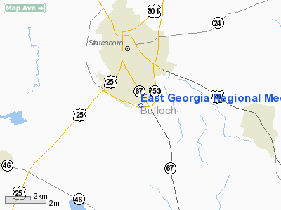
East Georgia Regional Medical Center Heliport |
Location
& QuickFacts
|
FAA Information Effective: |
2007-01-18 |
|
Airport
Identifier: |
GA28 |
|
Airport
Status: |
Operational |
|
Longitude/Latitude: |
081-46-06.0000W/32-24-19.0000N
-81.768333/32.405278 (Estimated) |
|
Elevation: |
212 ft / 64.62 m (Estimated) |
|
Land: |
35
acres |
|
From
nearest city: |
0 nautical miles S of Statesboro, GA |
|
Location: |
Bulloch County, GA |
|
Magnetic Variation: |
05W (1995) |
Owner
& Manager
|
Ownership: |
Privately owned |
|
Owner: |
East Georgia Rgnl Medical Center |
|
Address: |
1500 Fair Road
Statesboro, GA 30458 |
|
Phone number: |
912-486-1000 |
|
Manager: |
Jay Burdett |
|
Address: |
1499 Fair Road
Statesboro, GA 30458 |
|
Phone number: |
912-486-1651 |
Airport
Operations and Facilities
|
Airport Use: |
Private
MEDICAL USE. |
|
Wind
indicator: |
Yes |
|
Segmented
Circle: |
No |
|
Control
Tower: |
No |
|
Sectional
chart: |
Atlanta |
|
Region: |
ASO - Southern |
|
Boundary
ARTCC: |
ZJX - Jacksonville |
|
Tie-in
FSS: |
MCN - Macon |
|
FSS
Phone: |
478-784-1155 |
|
FSS
Toll Free: |
1-800-WX-BRIEF |
|
Runway Information
Helipad H1
|
Dimension: |
90 x 90 ft / 27.4 x 27.4 m |
|
Surface: |
CONC, |
|
|
Runway H1 |
Runway |
|
Traffic
Pattern: |
Left |
Left |
|
Radio Navigation
Aids
|
ID |
Type |
Name |
Ch |
Freq |
Var |
Dist |
|
BZ |
NDB |
Bullo |
|
407.00 |
05W |
5.3 nm |
|
CWV |
NDB |
Claxton |
|
395.50 |
04W |
13.8 nm |
|
MHP |
NDB |
Metter |
|
432.00 |
03W |
16.1 nm |
|
JYL |
NDB |
Sylvania |
|
245.00 |
04W |
17.1 nm |
|
RVJ |
NDB |
Prison |
|
424.00 |
03W |
28.6 nm |
|
UQN |
NDB |
Onyun |
|
372.00 |
04W |
29.1 nm |
|
LNH |
NDB |
Millen |
|
205.00 |
05W |
31.1 nm |
|
MOQ |
NDB |
Mc Intosh |
|
263.00 |
04W |
37.0 nm |
|
EEX |
NDB |
Emanuel County |
|
309.00 |
04W |
38.1 nm |
|
BXG |
NDB |
Burke County |
|
356.00 |
04W |
40.1 nm |
|
ALD |
VOR |
Allendale |
|
116.70 |
01W |
43.7 nm |
|
SVN |
VOR/DME |
Hunter |
53X |
111.60 |
02W |
39.7 nm |
|
SAV |
VORTAC |
Savannah |
106Y |
115.95 |
06W |
32.9 nm |
|
SAV |
VOT |
Savannah Travis Fld |
|
111.00 |
|
33.3 nm |
Remarks
- PRVDD
VFR/PVT USE, AREA IS MKD, APCH/DEP ROUTES FROM 0 TO 360 DEGS, WIND INDICATOR
IS MAINTAINED.
Based
Aircraft
|
Aircraft
based on field: |
1 |
|
Helicopters: |
1 |
East Georgia Regional Medical Center Heliport
Address:
Bulloch County, GA
Tel:
912-486-1000, 912-486-1651
Images
and information placed above are from
http://www.airport-data.com/airport/GA28/
We
thank them for the data!
| General
Info |
| Country |
United
States |
| State |
GEORGIA
|
| FAA ID |
GA28
|
| Latitude |
32-24-19.000N
|
| Longitude |
081-46-06.000W
|
| Elevation |
212 feet
|
| Near City |
STATESBORO
|
We don't guarantee the information is fresh and accurate. The data may
be wrong or outdated.
For more up-to-date information please refer to other sources.
|
|


