 |
|
|
|
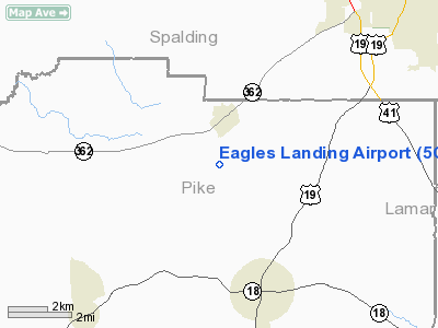
Location
& QuickFacts
|
FAA Information Effective: |
2007-01-18 |
|
Airport
Identifier: |
5GA3 |
|
Airport
Status: |
Operational |
|
Longitude/Latitude: |
084-21-54.7230W/33-09-36.4350N
-84.365201/33.160121 (Estimated) |
|
Elevation: |
980 ft / 298.70 m (Estimated) |
|
Land: |
0
acres |
|
From
nearest city: |
1 nautical miles SW of Williamson, GA |
|
Location: |
Pike County, GA |
|
Magnetic Variation: |
02W (1985) |
Owner
& Manager
|
Ownership: |
Privately owned |
|
Owner: |
Eagles Landing Hoa |
|
Address: |
P.o. Box 159
Williamson, GA 30292-9774 |
|
Phone number: |
770-229-2939 |
|
Manager: |
David R. Moffett |
|
Address: |
720 Lufbery Circle
Williamson, GA 30292-9774 |
|
Phone number: |
770-229-2939
770-335-3779. |
Airport
Operations and Facilities
|
Airport Use: |
Private |
|
Wind
indicator: |
Yes
ARPT HAS 4 WIND INDICATORS. |
|
Segmented Circle: |
No |
|
Control Tower: |
No |
|
Landing fee charge: |
No |
|
Sectional chart: |
Atlanta |
|
Region: |
ASO - Southern |
|
Boundary ARTCC: |
ZTL - Atlanta |
|
Tie-in FSS: |
MCN - Macon |
|
FSS on Airport: |
No |
|
FSS Phone: |
478-784-1155 |
|
FSS Toll Free: |
1-800-WX-BRIEF |
Airport
Services
|
Runway Information
Runway 13/31
|
Dimension: |
2500 x 100 ft / 762.0 x 30.5 m |
|
Surface: |
TURF, |
|
|
Runway 13 |
Runway 31 |
|
Traffic
Pattern: |
Left |
Right |
|
Obstruction: |
50 ft trees, 400.0 ft from runway, 1:1 slope
to clear |
, 1:1 slope to clear |
|
Runway 18/36
|
Dimension: |
3500 x 100 ft / 1066.8 x 30.5 m |
|
Surface: |
TURF, |
|
|
Runway 18 |
Runway 36 |
|
Traffic
Pattern: |
Left |
Right |
|
Obstruction: |
50 ft trees, 400.0 ft from runway |
|
|
Radio Navigation
Aids
|
ID |
Type |
Name |
Ch |
Freq |
Var |
Dist |
|
JHH |
NDB |
Griffin |
|
412.00 |
04W |
7.1 nm |
|
FF |
NDB |
Pecat |
|
316.00 |
02W |
10.4 nm |
|
OP |
NDB |
Yates |
|
339.00 |
03W |
17.0 nm |
|
EQQ |
NDB |
Coweta County |
|
234.00 |
03W |
18.4 nm |
|
BR |
NDB |
Redan |
|
266.00 |
02W |
29.3 nm |
|
PIM |
NDB |
Pine Mountain |
|
272.00 |
03W |
31.9 nm |
|
FT |
NDB |
Flanc |
|
344.00 |
02W |
38.7 nm |
|
VOF |
NDB |
Alcovy |
|
370.00 |
03W |
40.7 nm |
|
GPQ |
NDB |
Carrollton |
|
278.00 |
02W |
45.5 nm |
|
JNM |
NDB |
Monroe |
|
392.00 |
03W |
47.2 nm |
|
DOB |
TACAN |
Dobbins |
077X |
|
01W |
45.9 nm |
|
PDK |
VOR/DME |
Peachtree |
113X |
116.60 |
02W |
43.1 nm |
|
ATL |
VORTAC |
Atlanta |
116X |
116.90 |
00W |
28.4 nm |
|
LGC |
VORTAC |
Lagrange |
103X |
115.60 |
01E |
42.9 nm |
|
MCN |
VORTAC |
Macon |
089X |
114.20 |
01E |
45.9 nm |
|
CSG |
VORTAC |
Columbus |
118X |
117.10 |
01E |
46.4 nm |
|
ATL |
VOT |
Atlanta Muni |
|
111.00 |
|
30.1 nm |
Remarks
- (E111-2)
ARPT USERS ARE BRIEFED ON THE OPERATIONAL AGREEMENTS & INSTRUCTED
TO BE ALERT FOR & GIVE WAY TO ACFT OPERATING IN THE PEACH STATE
GLIDERPORT TFC PAT.
- VFR
OPERATIONS/PRIVATE USE. TRAFFIC PATTERNS ESTABLISHED EAST OF RWY 18/36.
COMPATIBLE OPERATIONAL AGREEMENT MAINTAINED WITH OPERATORS OF PEACH
STATE GLIDERPORT AND VINTAGE AIRPORT.
Based
Aircraft
|
Aircraft
based on field: |
29 |
|
Single
Engine Airplanes: |
26 |
|
Multi
Engine Airplanes: |
3 |
Eagles Landing Airport
Address:
Pike County, GA
Tel:
770-229-2939, 770-335-3779
Images
and information placed above are from
http://www.airport-data.com/airport/5GA3/
We
thank them for the data!
| General
Info |
| Country |
United
States |
| State |
GEORGIA
|
| FAA ID |
5GA3
|
| Latitude |
33-09-36.435N
|
| Longitude |
084-21-54.723W
|
| Elevation |
980 feet
|
| Near City |
WILLIAMSON
|
We don't guarantee the information is fresh and accurate. The data may
be wrong or outdated.
For more up-to-date information please refer to other sources.
|
|


