 |
|
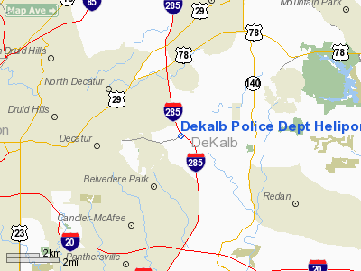
Dekalb Police Department Heliport |
|
|
Location
& QuickFacts
|
FAA Information Effective: |
2007-01-18 |
|
Airport
Identifier: |
GA58 |
|
Airport
Status: |
Operational |
|
Longitude/Latitude: |
084-14-32.7160W/33-46-38.3770N
-84.242421/33.777327 (Estimated) |
|
Elevation: |
1080 ft / 329.18 m (Estimated) |
|
Land: |
0
acres |
|
From
nearest city: |
1 nautical miles E of Avondale Estates, GA |
|
Location: |
De Kalb County, GA |
|
Magnetic Variation: |
02W (1985) |
Owner
& Manager
|
Ownership: |
Publicly owned |
|
Owner: |
Dekalb Police Dept |
|
Address: |
4400 Memorial Drive
Decatur, GA 30032 |
|
Phone
number: |
404-294-2537 |
|
Manager: |
G. A. Rivers |
|
Address: |
Dekalb Police Dept, 4400 Memorial Dr
Decatur, GA 30032 |
|
Phone number: |
404-294-2537 |
Airport
Operations and Facilities
|
Airport Use: |
Private |
|
Wind
indicator: |
Yes |
|
Segmented
Circle: |
No |
|
Control
Tower: |
No |
|
Landing
fee charge: |
No |
|
Sectional
chart: |
Atlanta |
|
Region: |
ASO - Southern |
|
Boundary ARTCC: |
ZTL - Atlanta |
|
Tie-in FSS: |
MCN - Macon |
|
FSS on Airport: |
No |
|
FSS Phone: |
478-784-1155 |
|
FSS Toll Free: |
1-800-WX-BRIEF |
Airport
Services
|
Airframe Repair: |
NONE |
|
Power Plant Repair: |
NONE |
|
Runway Information
Helipad H1
|
Dimension: |
25
x 25 ft / 7.6 x 7.6 m |
|
Surface: |
CONC, |
|
|
Runway H1 |
Runway |
|
Traffic
Pattern: |
Left |
Left |
|
Radio Navigation
Aids
|
ID |
Type |
Name |
Ch |
Freq |
Var |
Dist |
|
BR |
NDB |
Redan |
|
266.00 |
02W |
8.6 nm |
|
FT |
NDB |
Flanc |
|
344.00 |
02W |
19.8 nm |
|
VOF |
NDB |
Alcovy |
|
370.00 |
03W |
24.7 nm |
|
JNM |
NDB |
Monroe |
|
392.00 |
03W |
25.9 nm |
|
FKV |
NDB |
Flowery Branch |
|
365.00 |
03W |
30.6 nm |
|
DJD |
NDB |
Canton |
|
415.00 |
04W |
31.1 nm |
|
FF |
NDB |
Pecat |
|
316.00 |
02W |
31.2 nm |
|
BMW |
NDB |
Barrow County |
|
404.00 |
03W |
33.9 nm |
|
JHH |
NDB |
Griffin |
|
412.00 |
04W |
35.7 nm |
|
EQQ |
NDB |
Coweta County |
|
234.00 |
03W |
39.2 nm |
|
EVZ |
NDB |
Cartersville |
|
308.00 |
04W |
39.2 nm |
|
DDA |
NDB |
Commerce |
|
244.00 |
03W |
39.9 nm |
|
JZP |
NDB |
Pickens County |
|
285.00 |
04W |
42.2 nm |
|
GPQ |
NDB |
Carrollton |
|
278.00 |
02W |
46.2 nm |
|
DOB |
TACAN |
Dobbins |
077X |
|
01W |
15.6 nm |
|
PDK |
VOR/DME |
Peachtree |
113X |
116.60 |
02W |
6.5 nm |
|
ATL |
VORTAC |
Atlanta |
116X |
116.90 |
00W |
13.1 nm |
|
AHN |
VORTAC |
Athens |
33 |
109.60 |
00E |
46.9 nm |
|
RMG |
VORTAC |
Rome |
101X |
115.40 |
01E |
49.5 nm |
|
ATL |
VOT |
Atlanta Muni |
|
111.00 |
|
11.6 nm |
Remarks
Based Aircraft
|
Aircraft
based on field: |
2 |
|
Helicopters: |
2 |
Dekalb Police Department Heliport
Address:
De Kalb County, GA
Tel:
404-294-2537
Images
and information placed above are from
http://www.airport-data.com/airport/GA58/
We
thank them for the data!
| General
Info |
| Country |
United
States |
| State |
GEORGIA
|
| FAA ID |
GA58
|
| Latitude |
33-46-38.377N
|
| Longitude |
084-14-32.716W
|
| Elevation |
1080 feet
|
| Near City |
AVONDALE
ESTATES |
We don't guarantee the information is fresh and accurate. The data may
be wrong or outdated.
For more up-to-date information please refer to other sources.
|
|


