 |
|
| Davis Field |
| IATA: none – ICAO: none – FAA LID: 3J6 |
| Summary |
| Airport type |
Public |
| Owner |
Charlton County |
| Serves |
Folkston, Georgia |
| Elevation AMSL |
68 ft / 21 m |
| Coordinates |
30°47′47″N 082°01′41″W / 30.79639°N 82.02806°W / 30.79639; -82.02806 |
| Runways |
| Direction |
Length |
Surface |
| ft |
m |
| 18/36 |
2,500 |
762 |
Asphalt |
| Statistics (2006) |
| Aircraft operations |
3,000 |
| Source: Federal Aviation Administration |
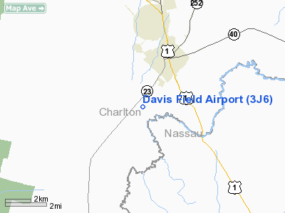
Davis Field (FAA LID: 3J6) is a county-owned public-use airport located three nautical miles (6 km) southwest of the central business district of Folkston, a city in Charlton County, Georgia, United States.
Facilities and aircraft
Davis Field covers an area of 30 acres (12 ha) at an elevation of 68 feet (21 m) above mean sea level. It has one runway designated 18/36 with a 2,500 by 50 ft (762 x 15 m) asphalt pavement. For the 12-month period ending February 2, 2006, the airport had 3,000 aircraft operations, an average of 250 per month, all of which were general aviation.
The above content comes from Wikipedia and is published under free licenses – click here to read more.
Location
& QuickFacts
|
FAA Information Effective: |
2007-01-18 |
|
Airport
Identifier: |
3J6 |
|
Airport
Status: |
Operational |
|
Longitude/Latitude: |
082-01-39.4160W/30-47-50.8370N
-82.027616/30.797455 (Estimated) |
|
Elevation: |
68
ft / 20.73 m (Estimated) |
|
Land: |
30
acres |
|
From
nearest city: |
3 nautical miles SW of Folkston, GA |
|
Location: |
Charlton County, GA |
|
Magnetic Variation: |
03W (1985) |
Owner
& Manager
|
Ownership: |
Publicly owned |
|
Owner: |
Charlton County |
|
Address: |
100 S Third St
Folkston, GA 31537 |
|
Phone
number: |
912-496-2549 |
|
Manager: |
Steve Nance, County Administrator |
|
Address: |
100 S Third St
Folkston, GA 31537 |
|
Phone number: |
912-496-2549 |
Airport
Operations and Facilities
|
Airport Use: |
Open to public |
|
Wind
indicator: |
Yes |
|
Segmented
Circle: |
Yes |
|
Control
Tower: |
No |
|
Lighting
Schedule: |
DUSK-DAWN
MIRL RY 18/36 PRESET LOW INTST DUSK-2030; AFTER 2030 ACTVT
- CTAF. |
|
Beacon
Color: |
Clear-Green (lighted land airport) |
|
Landing
fee charge: |
No |
|
Sectional
chart: |
Jacksonville |
|
Region: |
ASO - Southern |
|
Traffic
Pattern Alt: |
1000 ft |
|
Boundary
ARTCC: |
ZJX - Jacksonville |
|
Tie-in
FSS: |
MCN - Macon |
|
FSS
on Airport: |
No |
|
FSS
Phone: |
478-784-1155 |
|
FSS
Toll Free: |
1-800-WX-BRIEF |
|
NOTAMs
Facility: |
MCN (NOTAM-d service avaliable) |
Airport
Communications
Airport
Services
|
Bottled
Oxygen: |
NONE |
|
Bulk
Oxygen: |
NONE |
|
Runway Information
Runway 18/36
|
Dimension: |
2500 x 50 ft / 762.0 x 15.2 m |
|
Surface: |
ASPH, Fair Condition |
|
Weight
Limit: |
Single wheel: 12500 lbs. |
|
Edge
Lights: |
Medium |
|
|
Runway 18 |
Runway 36 |
|
Traffic
Pattern: |
Left |
Left |
|
Markings: |
Basic, Poor Condition
RY MARKINGS BADLY FADED. |
Basic, Poor Condition
RY MARKINGS BADLY FADED. |
|
Displaced
threshold: |
0.00 ft |
650.00
ft |
|
Obstruction: |
22 ft trees, 530.0 ft from runway, 100 ft left
of centerline, 15:1 slope to clear
RY 18 +6 FT TREES AT THLD & 56 FT RIGHT. |
50 ft trees, 200.0 ft from runway, 84 ft right
of centerline
+30 FT TREES AT DSPLCD THLD 125 FT L; 0:1 BASED ON DSPLCD
THLD.
+50
FT TREES 84 FT L & R OF THLD. |
|
Radio Navigation
Aids
|
ID |
Type |
Name |
Ch |
Freq |
Var |
Dist |
|
JA |
NDB |
Dinns |
|
344.00 |
03W |
23.1 nm |
|
EYA |
NDB |
Eastport |
|
357.00 |
03W |
31.2 nm |
|
HEG |
NDB |
Herlong |
|
332.00 |
02W |
33.3 nm |
|
JUK |
NDB |
Mc Kinnon |
|
353.00 |
05W |
39.2 nm |
|
HOE |
NDB |
Homerville |
|
209.00 |
03W |
41.4 nm |
|
JES |
NDB |
Slover |
|
340.00 |
04W |
46.0 nm |
|
LCQ |
NDB |
Lake City |
|
204.00 |
03W |
46.6 nm |
|
NZC |
TACAN |
Cecil/dcmsnd |
088X |
|
04W |
35.6 nm |
|
NIP |
TACAN |
Jacksonville |
19X |
|
04W |
38.4 nm |
|
NRB |
TACAN |
Mayport |
051X |
|
03W |
39.8 nm |
|
VQQ |
VOR |
Cecil |
|
117.90 |
03W |
35.8 nm |
|
TAY |
VORTAC |
Taylor |
076X |
112.90 |
03W |
32.4 nm |
|
SSI |
VORTAC |
Brunswick |
035X |
109.80 |
04W |
33.6 nm |
|
CRG |
VORTAC |
Craig |
092X |
114.50 |
03W |
38.4 nm |
|
AYS |
VORTAC |
Waycross |
039X |
110.20 |
00E |
39.3 nm |
|
JAX |
VOT |
Jacksonville Intl |
|
111.00 |
|
25.3 nm |
|
BQK |
VOT |
Brunswick |
|
111.00 |
|
41.0 nm |
Remarks
- LGTD
272 FT AGL TOWER 1000 FT WEST.
Based
Aircraft
|
Aircraft
based on field: |
6 |
|
Single
Engine Airplanes: |
6 |
Operational Statistics
Time Period: 2005-02-03
- 2006-02-02
|
Aircraft
Operations: |
58/Week |
|
General
Aviation Local: |
66.7% |
|
General
Aviation Itinerant: |
33.3% |
Davis Field Airport
Address:
Charlton County, GA
Tel:
912-496-2549
Images
and information placed above are from
http://www.airport-data.com/airport/3J6/
We
thank them for the data!
| General
Info |
| Country |
United
States |
| State |
GEORGIA
|
| FAA ID |
3J6
|
| Latitude |
30-47-50.837N
|
| Longitude |
082-01-39.416W
|
| Elevation |
68 feet
|
| Near City |
FOLKSTON
|
We don't guarantee the information is fresh and accurate. The data may
be wrong or outdated.
For more up-to-date information please refer to other sources.
|
|


