 |
|
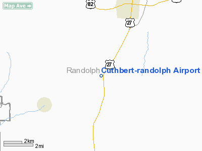
Cuthbert - Randolph Airport |
|
|
Location
& QuickFacts
|
FAA Information Effective: |
2007-01-18 |
|
Airport
Identifier: |
25J |
|
Airport
Status: |
Operational |
|
Longitude/Latitude: |
084-49-29.7190W/31-42-00.5970N
-84.824922/31.700166 (Estimated) |
|
Elevation: |
457 ft / 139.29 m (Estimated) |
|
Land: |
46
acres |
|
From
nearest city: |
4 nautical miles SW of Cuthbert, GA |
|
Location: |
Randolph County, GA |
|
Magnetic Variation: |
01W (1985) |
Owner
& Manager
|
Ownership: |
Publicly owned |
|
Owner: |
Randolph County |
|
Address: |
309 Webster Street
Cuthbert, GA 39840 |
|
Phone
number: |
229-732-6440 |
|
Manager: |
Greg Whatley |
|
Address: |
P O Box 234
Cuthbert, GA 39840 |
|
Phone number: |
229-732-2611
CHAIRMAN ARPT AUTH. |
Airport
Operations and Facilities
|
Airport Use: |
Open to public |
|
Wind
indicator: |
Yes |
|
Segmented
Circle: |
Yes |
|
Control
Tower: |
No |
|
Lighting
Schedule: |
DUSK-DAWN
MIRL RWY 18/36 - CTAF. |
|
Beacon
Color: |
Clear-Green (lighted land airport) |
|
Landing
fee charge: |
No |
|
Sectional
chart: |
Jacksonville |
|
Region: |
ASO - Southern |
|
Boundary
ARTCC: |
ZJX - Jacksonville |
|
Tie-in
FSS: |
MCN - Macon |
|
FSS
on Airport: |
No |
|
FSS
Phone: |
478-784-1155 |
|
FSS
Toll Free: |
1-800-WX-BRIEF |
|
NOTAMs
Facility: |
MCN (NOTAM-d service avaliable) |
|
Federal Agreements: |
NGY |
Airport
Communications
Airport
Services
|
Airframe Repair: |
NONE |
|
Power Plant Repair: |
NONE |
|
Bottled
Oxygen: |
NONE |
|
Bulk
Oxygen: |
NONE |
|
Runway Information
Runway 18/36
|
Dimension: |
3000 x 60 ft / 914.4 x 18.3 m |
|
Surface: |
ASPH, Poor Condition
RY HAS EXCESSIVE CRACKING AND DETERIORATION. |
|
Weight
Limit: |
Single wheel: 16000 lbs. |
|
Edge
Lights: |
Medium |
|
|
Runway 18 |
Runway 36 |
|
Traffic
Pattern: |
Left |
Left |
|
Markings: |
Basic, Poor Condition
RY 18/36 MARKINGS FADED. |
Basic, Poor Condition |
|
Obstruction: |
38 ft trees, 656.0 ft from runway, 12:1 slope
to clear |
55 ft trees, 2015.0 ft from runway, 33:1 slope
to clear
RY 36 HAS +10 FT BRUSH 100 FT FM THLD & 80 FT LEFT. |
|
Radio Navigation
Aids
|
ID |
Type |
Name |
Ch |
Freq |
Var |
Dist |
|
IWJ |
NDB |
Blaak |
|
344.00 |
03W |
14.7 nm |
|
AB |
NDB |
Putny |
|
227.00 |
02W |
31.7 nm |
|
AWS |
NDB |
Lawson |
|
335.00 |
02W |
37.1 nm |
|
CXU |
NDB |
Camilla |
|
369.00 |
02W |
42.0 nm |
|
LYZ |
NDB |
Willis |
|
359.00 |
01W |
46.3 nm |
|
LKG |
NDB |
Lindbergh |
|
242.00 |
03W |
46.4 nm |
|
HYE |
NDB |
Hanchey |
|
221.00 |
00E |
46.8 nm |
|
HEY |
VOR |
Hanchey |
|
110.60 |
02E |
46.7 nm |
|
LSF |
VOR/DME |
Lawson |
051X |
111.40 |
02W |
39.0 nm |
|
EUF |
VORTAC |
Eufaula |
029X |
109.20 |
02E |
21.7 nm |
|
PZD |
VORTAC |
Pecan |
108X |
116.10 |
02W |
27.3 nm |
|
RRS |
VORTAC |
Wiregrass |
053X |
111.60 |
02E |
39.9 nm |
Remarks
- DEER
FREQUENTLY ON AND INVOF ARPT.
Based
Aircraft
|
Aircraft
based on field: |
2 |
|
Single
Engine Airplanes: |
2 |
Operational Statistics
Time Period: 2005-04-07 - 2006-04-06
|
Aircraft
Operations: |
43/Week |
|
General
Aviation Local: |
50.0% |
|
General
Aviation Itinerant: |
50.0% |
Cuthbert-randolph Airport
Address:
Randolph County, GA
Tel:
229-732-6440,
229-732-2611
Images
and information placed above are from
http://www.airport-data.com/airport/25J/
We
thank them for the data!
| General
Info |
| Country |
United
States |
| State |
GEORGIA
|
| FAA ID |
25J
|
| Latitude |
31-42-00.597N
|
| Longitude |
084-49-29.719W
|
| Elevation |
457 feet
|
| Near City |
CUTHBERT
|
We don't guarantee the information is fresh and accurate. The data may
be wrong or outdated.
For more up-to-date information please refer to other sources.
|
|


