 |
|
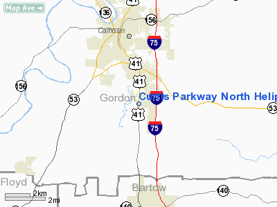
Curtis Parkway North Heliport |
Location
& QuickFacts
|
FAA Information Effective: |
2007-01-18 |
|
Airport
Identifier: |
99GA |
|
Airport
Status: |
Operational |
|
Longitude/Latitude: |
084-56-03.7930W/34-27-04.3180N
-84.934387/34.451199 (Estimated) |
|
Elevation: |
660 ft / 201.17 m (Estimated) |
|
Land: |
0
acres |
|
From
nearest city: |
2 nautical miles E of Calhoun, GA |
|
Location: |
Gordon County, GA |
|
Magnetic Variation: |
02W (1990) |
Owner
& Manager
|
Ownership: |
Privately owned |
|
Owner: |
North Georgia Helicopters Inc |
|
Address: |
190 Three Oaks Drive
Calhoun, GA 30701 |
|
Phone
number: |
706-629-8989 |
|
Manager: |
Ashley A. Smith |
|
Address: |
190 Three Oaks Drive
Calhoun, GA 30701 |
|
Phone number: |
706-629-8989 |
Airport
Operations and Facilities
|
Airport Use: |
Private |
|
Wind indicator: |
Yes |
|
Segmented Circle: |
No |
|
Control Tower: |
No |
|
Sectional chart: |
Atlanta |
|
Region: |
ASO - Southern |
|
Boundary ARTCC: |
ZTL - Atlanta |
|
Tie-in FSS: |
MCN - Macon |
|
FSS on Airport: |
No |
|
FSS Phone: |
478-784-1155 |
|
FSS Toll Free: |
1-800-WX-BRIEF |
Airport
Communications
|
Runway Information
Helipad H1
|
Dimension: |
220 x 180 ft / 67.1 x 54.9 m |
|
Surface: |
TURF, |
|
|
Runway H1 |
Runway |
|
Traffic
Pattern: |
Left |
Left |
|
Radio Navigation
Aids
|
ID |
Type |
Name |
Ch |
Freq |
Var |
Dist |
|
OUK |
NDB |
Calhoun |
|
323.00 |
02W |
3.0 nm |
|
OYD |
NDB |
Floyd |
|
388.00 |
02W |
14.6 nm |
|
EVZ |
NDB |
Cartersville |
|
308.00 |
04W |
15.8 nm |
|
UWI |
NDB |
Whitfield |
|
400.00 |
03W |
20.3 nm |
|
JZP |
NDB |
Pickens County |
|
285.00 |
04W |
23.5 nm |
|
DJD |
NDB |
Canton |
|
415.00 |
04W |
25.2 nm |
|
FTP |
NDB |
Fort Payne |
|
426.00 |
01W |
36.9 nm |
|
HDI |
NDB |
Hardwick |
|
369.00 |
01W |
42.2 nm |
|
FT |
NDB |
Flanc |
|
344.00 |
02W |
43.9 nm |
|
CQN |
NDB |
Daisy |
|
341.00 |
02W |
44.4 nm |
|
APT |
NDB |
Jasper |
|
382.00 |
02W |
48.6 nm |
|
DOB |
TACAN |
Dobbins |
077X |
|
01W |
38.6 nm |
|
PDK |
VOR/DME |
Peachtree |
113X |
116.60 |
02W |
46.9 nm |
|
RMG |
VORTAC |
Rome |
101X |
115.40 |
01E |
19.6 nm |
|
GQO |
VORTAC |
Choo Choo |
105X |
115.80 |
01E |
32.5 nm |
Remarks
- VFR;
PRIVATE USE; OPNS CONDUCTED FM 310 DEG TO 140 DEG; AREA IS MARKED; WIND
INDICATOR IS MAINTAINED.
Based
Aircraft
|
Aircraft
based on field: |
1 |
|
Helicopters: |
1 |
Curtis Parkway North Heliport
Address:
Gordon County, GA
Tel:
706-629-8989
Images
and information placed above are from
http://www.airport-data.com/airport/99GA/
We
thank them for the data!
| General
Info |
| Country |
United
States |
| State |
GEORGIA
|
| FAA ID |
99GA
|
| Latitude |
34-27-04.318N
|
| Longitude |
084-56-03.793W
|
| Elevation |
660 feet
|
| Near City |
CALHOUN
|
We don't guarantee the information is fresh and accurate. The data may
be wrong or outdated.
For more up-to-date information please refer to other sources.
|
|


