 |
|
| Cook County Airport |
| IATA: none – ICAO: none – FAA LID: 15J |
| Summary |
| Airport type |
Public |
| Owner |
Cook County |
| Serves |
Cook County, Georgia |
| Location |
Adel, Georgia |
| Elevation AMSL |
236 ft / 72 m |
| Coordinates |
31°08′16″N 083°27′11″W / 31.13778°N 83.45306°W / 31.13778; -83.45306 |
| Runways |
| Direction |
Length |
Surface |
| ft |
m |
| 5/23 |
4,001 |
1,220 |
Asphalt |
| 15/33 |
4,000 |
1,219 |
Asphalt |
| Statistics (2007) |
| Aircraft operations |
8,000 |
| Based aircraft |
36 |
| Source: Federal Aviation Administration |
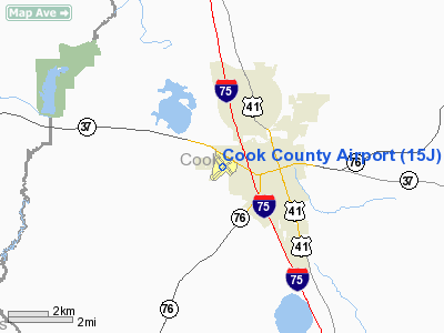
Cook County Airport (FAA LID: 15J) is a county-owned public-use airport located one nautical mile (2 km) west of the central business district of Adel, a city in Cook County, Georgia, United States.
Facilities and aircraft
Cook County Airport covers an area of 368 acres (149 ha) at an elevation of 236 feet (72 m) above mean sea level. It has two asphalt paved runways: 5/23 is 4,001 by 100 feet (1,220 x 30 m); 15/33 is 4,000 by 100 feet (1,219 x 30 m).
For the 12-month period ending May 31, 2007, the airport had 8,000 aircraft operations, an average of 21 per day, all of which were general aviation. At that time there were 36 aircraft based at this airport: 92% single-engine, 6% multi-engine and 3% ultralight.
The above content comes from Wikipedia and is published under free licenses – click here to read more.
|
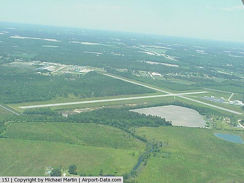 |
(Click on the photo to enlarge) |
|
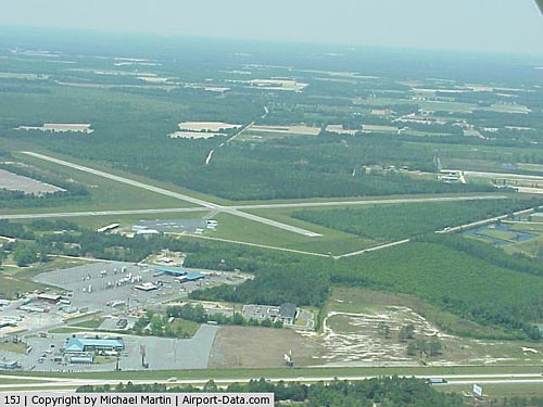 |
(Click on the photo to enlarge) |
Location
& QuickFacts
|
FAA Information Effective: |
2007-01-18 |
|
Airport
Identifier: |
15J |
|
Airport
Status: |
Operational |
|
Longitude/Latitude: |
083-27-12.0000W/31-08-16.0000N
-83.453333/31.137778 (Estimated) |
|
Elevation: |
236 ft / 71.93 m (Estimated) |
|
Land: |
368 acres |
|
From
nearest city: |
1 nautical miles W of Adel, GA |
|
Location: |
Cook County, GA |
|
Magnetic
Variation: |
04W (2000) |
Owner
& Manager
|
Ownership: |
Publicly owned |
|
Owner: |
Cook County |
|
Address: |
209 N Parish
Adel, GA 31620 |
|
Phone
number: |
229-896-2266 |
|
Manager: |
Ted Holt
CHAIRMAN AIRPORT AUTHORITY. |
|
Address: |
P.o. Box 652
Adel, GA 31620 |
|
Phone
number: |
229-560-6866
ARPT PHONE (229) 896-8245. |
Airport
Operations and Facilities
|
Airport Use: |
Open to public |
|
Wind
indicator: |
Yes |
|
Segmented
Circle: |
Yes |
|
Control
Tower: |
No |
|
Lighting
Schedule: |
DUSK-DAWN
ACTVT MIRL RY 05/23 - CTAF. |
|
Beacon
Color: |
Clear-Green (lighted land airport) |
|
Landing
fee charge: |
No |
|
Sectional
chart: |
Jacksonville |
|
Region: |
ASO - Southern |
|
Boundary
ARTCC: |
ZJX - Jacksonville |
|
Tie-in
FSS: |
MCN - Macon |
|
FSS
on Airport: |
No |
|
FSS
Phone: |
478-784-1155 |
|
FSS
Toll Free: |
1-800-WX-BRIEF |
|
NOTAMs
Facility: |
MCN (NOTAM-d service avaliable) |
|
Federal
Agreements: |
NGY3 |
Airport
Communications
|
CTAF: |
122.800 |
|
Unicom: |
122.800 |
Airport
Services
|
Fuel available: |
100LL |
|
Airframe Repair: |
MINOR |
|
Power Plant Repair: |
MINOR |
|
Bottled
Oxygen: |
NONE |
|
Bulk
Oxygen: |
NONE |
|
Runway Information
Runway 05/23
|
Dimension: |
4001 x 100 ft / 1219.5 x 30.5 m |
|
Surface: |
ASPH, Good Condition |
|
Weight
Limit: |
Single wheel: 30000 lbs.
Dual wheel: 30000 lbs. |
|
Edge
Lights: |
Medium |
|
|
Runway 05 |
Runway 23 |
|
Longitude: |
083-27-30.6730W |
083-26-56.8260W |
|
Latitude: |
31-07-57.2970N |
31-08-24.1300N |
|
Elevation: |
233.00
ft |
234.00
ft |
|
Alignment: |
47 |
127 |
|
Traffic
Pattern: |
Left |
Left |
|
Markings: |
Non-precision instrument, Good Condition |
Non-precision instrument, Good Condition |
|
VASI: |
2-light PAPI on left side |
2-light PAPI on left side |
|
Obstruction: |
69
ft trees, 959.0 ft from runway, 250 ft left of centerline,
11:1 slope to clear |
18
ft trees, 506.0 ft from runway, 150L/ ft right of centerline,
17:1 slope to clear |
|
Runway 15/33
|
Dimension: |
4000 x 100 ft / 1219.2 x 30.5 m |
|
Surface: |
ASPH, Good Condition |
|
Weight
Limit: |
Single wheel: 30000 lbs.
Dual wheel: 30000 lbs. |
|
|
Runway 15 |
Runway 33 |
|
Longitude: |
083-27-21.7200W |
083-26-55.2400W |
|
Latitude: |
31-08-37.6700N |
31-08-05.3000N |
|
Elevation: |
234.00
ft |
234.00
ft |
|
Alignment: |
127 |
127 |
|
Traffic
Pattern: |
Left |
Left |
|
Markings: |
Basic, Good Condition |
Basic, Good Condition |
|
Displaced
threshold: |
600.00
ft |
350.00
ft |
|
Obstruction: |
14
ft trees, 284.0 ft from runway, 120 ft right of centerline,
6:1 slope to clear
RWY 15 APCH RATIO 20:1 TO DSPLCD THLD; 33 FT TREES 660 FT
OUT, 160 FT LEFT. |
50
ft trees, 900.0 ft from runway, 14:1 slope to clear
RWY 33 APCH RATIO 20:1 TO DSPLCD THLD; 59 FT TREES 1180 FT
OUT ACROSS APCH. |
|
Radio Navigation
Aids
|
ID |
Type |
Name |
Ch |
Freq |
Var |
Dist |
|
TM |
NDB |
Tifto |
|
409.00 |
03W |
13.6 nm |
|
GTP |
NDB |
Patten |
|
245.00 |
02W |
22.1 nm |
|
SUR |
NDB |
Fitzgerald |
|
362.00 |
03W |
29.8 nm |
|
OWC |
NDB |
Coffee County |
|
390.00 |
03W |
31.6 nm |
|
HOE |
NDB |
Homerville |
|
209.00 |
03W |
35.4 nm |
|
CYR |
NDB |
Caidy |
|
338.00 |
01W |
39.3 nm |
|
CXU |
NDB |
Camilla |
|
369.00 |
02W |
40.6 nm |
|
AB |
NDB |
Putny |
|
227.00 |
02W |
46.4 nm |
|
IFM |
VOR |
Tift Myers |
|
112.50 |
01W |
17.6 nm |
|
MGR |
VOR/DME |
Moultrie |
025X |
108.80 |
02W |
18.4 nm |
|
OTK |
VOR/DME |
Valdosta |
095X |
114.80 |
02W |
23.3 nm |
|
VAD |
VORTAC |
Moody |
080X |
113.30 |
03W |
17.1 nm |
|
GEF |
VORTAC |
Greenville |
027X |
109.00 |
01E |
39.1 nm |
|
AYS |
VORTAC |
Waycross |
039X |
110.20 |
00E |
46.8 nm |
Remarks
- ULTRALIGHT
ACTIVITY ON & INVOF ARPT.
- EXISTED
PRIOR TO 1959.
Based
Aircraft
|
Aircraft
based on field: |
36 |
|
Single
Engine Airplanes: |
33 |
|
Multi
Engine Airplanes: |
2 |
|
Ultralights: |
1 |
Operational Statistics
Time Period: 2004-04-28 - 2005-04-27
|
Aircraft
Operations: |
154/Week |
|
General
Aviation Local: |
50.0% |
|
General
Aviation Itinerant: |
50.0% |
Cook County Airport
Address: Cook County, GA
Tel:
229-896-2266, 229-560-6866
Images
and information placed above are from
http://www.airport-data.com/airport/15J/
We
thank them for the data!
| General
Info |
| Country |
United
States |
| State |
GEORGIA
|
| FAA ID |
15J
|
| Latitude |
31-08-16.100N
|
| Longitude |
083-27-11.100W
|
| Elevation |
235 feet
|
| Near City |
ADEL
|
We don't guarantee the information is fresh and accurate. The data may
be wrong or outdated.
For more up-to-date information please refer to other sources.
|
|


