 |
|
Cobb County - Mc Collum Field Airport |
Cobb County Airport
McCollum Field |
| IATA: none â ICAO: KRYY â FAA LID: RYY |
| Summary |
| Airport type |
Public |
| Owner |
Cobb County |
| Operator |
County Department of Transportation |
| Serves |
Atlanta |
| Location |
Kennesaw, Georgia |
| Elevation AMSL |
1,040 ft / 317 m |
| Coordinates |
34°00â²47â³N 084°35â²55â³W / 34.01306°N 84.59861°W / 34.01306; -84.59861 |
| Website |
cobbdot.org/mccollum.htm |
| Runways |
| Direction |
Length |
Surface |
| ft |
m |
| 9/27 |
6,305 |
1,922 |
Asphalt |
| Statistics (2006) |
| Aircraft operations |
173,547 |
| Based aircraft |
358 |
| Source: Federal Aviation Administration |
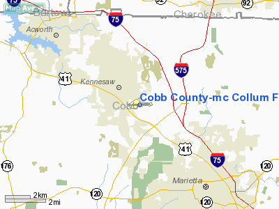
Cobb County Airport - McCollum Field (ICAO: KRYY, FAA LID: RYY) is a public airport located 21 miles (34 km) northwest of the central business district of Atlanta, immediately south of the city of Kennesaw in Cobb County, Georgia, United States. It is also designated as a weather station, although it does not operate between the hours of midnight and 6:00 a.m. (EST/EDT).
The airport is located on nearly 320 acres (1.3 km²) of land, has one runway which is 6,305 feet (1,921 m) long, and is east-west oriented, with headings of 089 and 269. Cobb Place is at the east end, with Cobb Parkway (U.S. 41) and old 41 intersecting McCollum Parkway on the west end. The airfield sits at 1,040 feet (317 m) above mean sea level somewhat above average terrain for the area.
There are over 350 aircraft based at McCollum, most of them being single-engine. The airport has a control tower.
The airport has 358 aircraft based on it: 251 single engine, 55 multi-engine, 39 jet aircraft and 13 helicopters. 49 percent of operations are single engine and 49 percent are multi-engine. Only 1 percent of operations are air taxi. No major commercial airlines service Cobb County Airport, but there are two charter companies and two major fixed-base operators. Aerial tours are very popular at the airport, as the Appalachian Mountains are less than a 30-minute flight away.
McCollum Field is owned by Cobb County, operated by the County Department of Transportation characterizing it as a municipal airport. It is managed by a full-time, professional airport manager. The airport employs almost 185 people, and had an annual economic impact of more than US$47 million to the local economy in 2002. History
McCollum Field opened in 1960 with a single 4,000-foot (1,219 m) runway. There was a stub taxiway connecting the runway with the ramp area, 60,000 square feet (5,570 m²) of aprons, and a single administration building. The airport steadily grew over the next 30 years with the greatest developments occurring in the early 1990s.
In 1991, the airport layout plan was first revised. The first full service fixed base operator opened in 1992. A second full service fixed base operator opened a year later. That same year, the Georgia State Patrol Hangar was constructed. The Air Traffic Control Tower was opened in 1995, followed by an Instrument Landing System glide slope the next year. Over the course of the decade, there were four major purchases of new land at a total cost of US$3.8 million in grants and an unspecified amount in local funds. In addition, 6 new hangars were built.
McCollum Field was first designed as a small field for general aviation. It is designated as a reliever airport for Hartsfield-Jackson Airport and DeKalb-Peachtree Airport. Cobb County is also the primary general aviation airport for the Atlanta suburban population. With an average of 475 takeoffs and landings each day, it is the third most trafficked airport in Georgia.
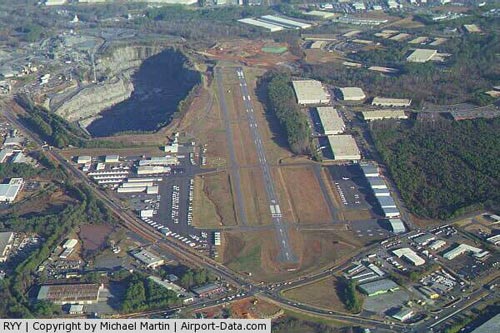
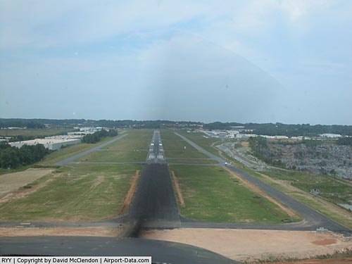
2008 runway
On December 4, 2008 the new 6,305 foot by 100 feet wide concrete runway was opened at 13:00 local time. The runway took 23 days to complete. During the runway construction of RWY "9-27" taxiway "A" was made temporary runway "8-26".
The above content comes from Wikipedia and is published under free licenses – click here to read more.
|
 |
(Click on the photo to enlarge) |
|
 |
(Click on the photo to enlarge) |
Location
& QuickFacts
|
FAA Information Effective: |
2007-01-18 |
|
Airport
Identifier: |
RYY |
|
Airport
Status: |
Operational |
|
Longitude/Latitude: |
084-35-54.8380W/34-00-47.3980N
-84.598566/34.013166 (Estimated) |
|
Elevation: |
1040 ft / 316.99 m (Surveyed) |
|
Land: |
309 acres |
|
From
nearest city: |
21 nautical miles NW of Atlanta, GA |
|
Location: |
Cobb County, GA |
|
Magnetic Variation: |
04W (2005) |
Owner
& Manager
|
Ownership: |
Publicly owned |
|
Owner: |
Cobb County |
|
Address: |
1723 Mccollum Parkway
Marietta, GA 30144-9612 |
|
Phone
number: |
770-528-1615 |
|
Manager: |
Karl A Von Hagel |
|
Address: |
1723 Mc Collum Pkwy Bldg 100
Kennesaw, GA 30144 |
|
Phone
number: |
770-528-1615 |
Airport
Operations and Facilities
|
Airport Use: |
Open to public |
|
Wind
indicator: |
Yes |
|
Segmented
Circle: |
Yes |
|
Control
Tower: |
Yes |
|
Lighting
Schedule: |
DUSK-DAWN
MIRL RY 09/27 PRESET LOW INTST; TO INCR INTST & ACTVT
REIL RY 27 WHEN ATCT CLSD - CTAF. |
|
Beacon
Color: |
Clear-Green (lighted land airport) |
|
Landing
fee charge: |
No |
|
Sectional
chart: |
Atlanta |
|
Region: |
ASO - Southern |
|
Traffic
Pattern Alt: |
1000 ft |
|
Boundary
ARTCC: |
ZTL - Atlanta |
|
Tie-in
FSS: |
MCN - Macon |
|
FSS
on Airport: |
No |
|
FSS
Phone: |
478-784-1155 |
|
FSS
Toll Free: |
1-800-WX-BRIEF |
|
NOTAMs
Facility: |
RYY (NOTAM-d service avaliable) |
|
Federal
Agreements: |
NGY |
Airport
Communications
|
CTAF: |
125.900 |
|
Unicom: |
122.700 |
Airport
Services
|
Fuel available: |
100LLA1+ |
|
Airframe Repair: |
MAJOR |
|
Power Plant Repair: |
MAJOR |
|
Bottled
Oxygen: |
NONE |
|
Bulk
Oxygen: |
HIGH/LOW |
|
Runway Information
Runway 09/27
|
Dimension: |
6305 x 75 ft / 1921.8 x 22.9 m |
|
Surface: |
ASPH, Good Condition |
|
Surface
Treatment: |
Saw-cut or plastic Grooved |
|
Weight
Limit: |
Single wheel: 30000 lbs.
Dual wheel: 44000 lbs. |
|
Edge
Lights: |
Medium |
|
|
Runway 09 |
Runway 27 |
|
Longitude: |
084-36-26.6360W |
084-35-11.7570W |
|
Latitude: |
34-00-46.8330N |
34-00-48.1630N |
|
Elevation: |
1040.00
ft |
998.00
ft |
|
Alignment: |
89 |
127 |
|
ILS
Type: |
|
ILS |
|
Traffic
Pattern: |
Right |
Left |
|
Markings: |
Precision instrument, Good Condition |
Precision instrument, Good Condition |
|
Crossing
Height: |
46.00
ft |
45.00
ft |
|
Displaced
threshold: |
1073.00
ft |
0.00
ft |
|
VASI: |
4-light PAPI on left side |
4-light PAPI on left side |
|
Visual
Glide Angle: |
4.00° |
3.00° |
|
Runway
End Identifier: |
|
Yes |
|
Obstruction: |
29
ft road, 287.0 ft from runway, 3:1 slope to clear
RY 09 APCH RATIO 20:1 TO DSPLCD THLD. +48 FT POLE 960 FT FM
THLD 400 FT LEFT.
ROAD 200 FT FM RY END, 87 FT RIGHT. |
45
ft , 875.0 ft from runway, 450 ft right of centerline, 15:1
slope to clear |
|
Decleard
distances: |
Take off run available 6305.00 ft
Take off distance available 6305.00 ft
Actual stop distance available 6305.00 ft
Landing distance available 5232.00 ft |
Take off run available 6305.00 ft
Take off distance available 6305.00 ft
Actual stop distance available 5405.00 ft
Landing distance available 5405.00 ft |
|
Radio Navigation
Aids
|
ID |
Type |
Name |
Ch |
Freq |
Var |
Dist |
|
FT |
NDB |
Flanc |
|
344.00 |
02W |
15.2 nm |
|
DJD |
NDB |
Canton |
|
415.00 |
04W |
15.4 nm |
|
EVZ |
NDB |
Cartersville |
|
308.00 |
04W |
16.5 nm |
|
BR |
NDB |
Redan |
|
266.00 |
02W |
26.4 nm |
|
JZP |
NDB |
Pickens County |
|
285.00 |
04W |
27.5 nm |
|
OUK |
NDB |
Calhoun |
|
323.00 |
02W |
28.5 nm |
|
OYD |
NDB |
Floyd |
|
388.00 |
02W |
33.0 nm |
|
FKV |
NDB |
Flowery Branch |
|
365.00 |
03W |
36.3 nm |
|
GPQ |
NDB |
Carrollton |
|
278.00 |
02W |
37.8 nm |
|
FF |
NDB |
Pecat |
|
316.00 |
02W |
43.2 nm |
|
EQQ |
NDB |
Coweta County |
|
234.00 |
03W |
45.8 nm |
|
JNM |
NDB |
Monroe |
|
392.00 |
03W |
46.5 nm |
|
VOF |
NDB |
Alcovy |
|
370.00 |
03W |
46.8 nm |
|
UWI |
NDB |
Whitfield |
|
400.00 |
03W |
49.7 nm |
|
DOB |
TACAN |
Dobbins |
077X |
|
01W |
7.5 nm |
|
PDK |
VOR/DME |
Peachtree |
113X |
116.60 |
02W |
17.1 nm |
|
ATL |
VORTAC |
Atlanta |
116X |
116.90 |
00W |
24.5 nm |
|
RMG |
VORTAC |
Rome |
101X |
115.40 |
01E |
27.4 nm |
|
ATL |
VOT |
Atlanta Muni |
|
111.00 |
|
23.0 nm |
Remarks
- BLASTING
SR-SS MON-FRI 2000' AER RWY 27.
- ARPT
MOWING IN PROGRESS SPRING THRU AUTUMN.
- COYOTES
ON & INVOF ARPT.
- N/S
TAXILANE 'CORPORATE ROW' LCTD NW OF ATCT RSTRD TO ACFT WITH WINGSPAN
OF 58 FT OR LESS.
- NOISE
ABATEMENT EFFORTS IN EFFECT, ALL VFR ACFT AVOID NOISE-SENSITIVE RESIDENTIAL
AREAS WEST AND NORTHWEST OF THE ARPT.
- RY
9 IS CALM WIND RY IN VFR CONDS.
- ACFT
ARRIVING OR DEPARTING WITH 80 FT OR GREATER WINGSPAN PPR 24 HRS BY COORDINATING
THROUGH THE LOCAL FBO AT 770-422-2345 OR 770-422-4300.
Based
Aircraft
|
Aircraft
based on field: |
358 |
|
Single
Engine Airplanes: |
251 |
|
Multi
Engine Airplanes: |
55 |
|
Jet Engine
Airplanes: |
39 |
|
Helicopters: |
13 |
Operational Statistics
Time Period: 2005-05-13 - 2006-05-12
|
Aircraft
Operations: |
476/Day |
|
General
Aviation Local: |
64.4% |
|
General
Aviation Itinerant: |
35.6% |
Cobb County-mc Collum Field Airport
Address:
Cobb County, GA
Tel:
770-528-1615
Images
and information placed above are from
http://www.airport-data.com/airport/RYY/
We
thank them for the data!
| General
Info |
| Country |
United
States |
| State |
GEORGIA
|
| FAA ID |
RYY
|
| Latitude |
34-00-47.398N
|
| Longitude |
084-35-54.838W
|
| Elevation |
1040 feet
|
| Near City |
MARIETTA
|
We don't guarantee the information is fresh and accurate. The data may
be wrong or outdated.
For more up-to-date information please refer to other sources.
|
|


