 |
|
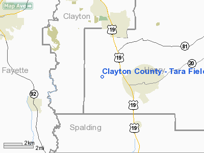
Clayton County - Tara Field Airport |
| Clayton County Airport - Tara Field |
| IATA: none â ICAO: K4A7 â FAA LID: 4A7 |
| Summary |
| Airport type |
Public |
| Operator |
Clayton County |
| Location |
Hampton, Georgia |
| Elevation AMSL |
874 ft / 266.4 m |
| Coordinates |
33°23â²21â³N 84°19â²56â³W / 33.38917°N 84.33222°W / 33.38917; -84.33222Coordinates: 33°23â²21â³N 84°19â²56â³W / 33.38917°N 84.33222°W / 33.38917; -84.33222 |
| Runways |
| Direction |
Length |
Surface |
| ft |
m |
| 6/24 |
4,503 |
1,373 |
Asphalt |
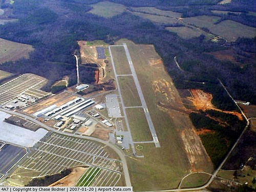
Clayton County Airport - Tara Field (ICAO: K4A7, FAA LID: 4A7), formerly known as Henry County Airport - Morris Field, or Bear Creek Airport is a municipal airport located about three miles (5 km) west of the central business district (CBD) of Hampton, Georgia, on the far south side of metro Atlanta in western Henry County, Georgia, USA. The airport covers 140 acres (57 ha) and has one asphalt runway.
Although the airport is located in Henry County, it has been owned and operated since 1992 by Clayton County to the north. It is not near most of that county, except for its very small southern tip. The north end of Clayton County has part of Hartsfield-Jackson Atlanta International Airport, thus Tara Field serves general aviation, especially for the Atlanta Motor Speedway immediately next to it. Plans are underway for both counties to jointly administer and own the airport.
There is no weather station or FAA flight info reported for this airport.
In July 2005, the airport and the adjacent speedway were hit by an F2 tornado on the evening of July 6. Millions of dollars in damage was done to the airport, in addition to the tens of millions at the speedway. Four airplanes were flipped over, hangars were torn apart, and fiberglass insulation and sheet metal were plastered into iron fences, along with another plane. The storm was a result of Hurricane Cindy, after it had already been downgraded to a tropical depression after landfall.
The above content comes from Wikipedia and is published under free licenses – click here to read more.
|
 |
(Click on the photo to enlarge) |
Location
& QuickFacts
|
FAA Information Effective: |
2007-01-18 |
|
Airport
Identifier: |
4A7 |
|
Airport
Status: |
Operational |
|
Longitude/Latitude: |
084-19-56.5000W/33-23-20.8000N
-84.332361/33.389111 (Estimated) |
|
Elevation: |
874 ft / 266.40 m (Surveyed) |
|
Land: |
140 acres |
|
From
nearest city: |
3 nautical miles W of Hampton, GA |
|
Location: |
Henry County, GA |
|
Magnetic
Variation: |
03W (1995) |
Owner
& Manager
|
Ownership: |
Publicly owned |
|
Owner: |
Clayton Co. |
|
Address: |
112 Smith Street - Admin Bldg
Jonesboro, GA 30236 |
|
Phone
number: |
770-946-3153 |
|
Manager: |
Gerry Adams |
|
Address: |
474 Mt Pleasant Rd
Hampton, GA 30228 |
|
Phone
number: |
770-946-3153 |
Airport
Operations and Facilities
|
Airport Use: |
Open to public |
|
Wind
indicator: |
Yes |
|
Segmented
Circle: |
Yes |
|
Control
Tower: |
No |
|
Lighting
Schedule: |
DUSK-DAWN
ACTVT MIRL RY 06/24, PAPI RYS 06 & 24 AND REIL RY 06
- CTAF. MIRL OPER DUSK-DAWN ONLY. |
|
Beacon
Color: |
Clear-Green (lighted land airport) |
|
Sectional
chart: |
Atlanta |
|
Region: |
ASO - Southern |
|
Boundary
ARTCC: |
ZTL - Atlanta |
|
Tie-in
FSS: |
MCN - Macon |
|
FSS
on Airport: |
No |
|
FSS
Phone: |
478-784-1155 |
|
FSS
Toll Free: |
1-800-WX-BRIEF |
|
NOTAMs
Facility: |
MCN (NOTAM-d service avaliable) |
|
Federal
Agreements: |
NMY |
Airport
Communications
|
CTAF: |
122.725 |
|
Unicom: |
122.725 |
Airport
Services
|
Fuel available: |
100LLA1+
FUEL 24 HR SELF-SERVE WITH CREDIT CARD. FUEL CALL OUT AVBL |
|
Airframe Repair: |
MAJOR |
|
Power Plant Repair: |
MAJOR |
|
Bottled
Oxygen: |
NONE |
|
Bulk
Oxygen: |
NONE |
|
Runway Information
Runway 06/24
|
Dimension: |
4503 x 75 ft / 1372.5 x 22.9 m |
|
Surface: |
ASPH, Good Condition |
|
Weight
Limit: |
Single wheel: 30000 lbs.
Dual wheel: 45000 lbs. |
|
Edge
Lights: |
Medium |
|
|
Runway 06 |
Runway 24 |
|
Longitude: |
084-20-18.1288W |
084-19-34.9273W |
|
Latitude: |
33-23-07.8199N |
33-23-33.7257N |
|
Elevation: |
852.00
ft |
874.00
ft |
|
Alignment: |
54 |
127 |
|
Traffic
Pattern: |
Right |
Left |
|
Markings: |
Non-precision instrument, Good Condition |
Non-precision instrument, Good Condition |
|
Crossing
Height: |
50.00
ft |
65.00
ft |
|
VASI: |
2-light PAPI on left side |
2-light PAPI on left side |
|
Visual
Glide Angle: |
3.00° |
3.45° |
|
Runway
End Identifier: |
Yes |
No |
|
Centerline
Lights: |
No |
No |
|
Touchdown
Lights: |
No |
No |
|
Obstruction: |
5
ft trees, 300.0 ft from runway, 220 ft left of centerline,
20:1 slope to clear |
, 50:1 slope to clear |
|
Radio Navigation
Aids
|
ID |
Type |
Name |
Ch |
Freq |
Var |
Dist |
|
FF |
NDB |
Pecat |
|
316.00 |
02W |
9.4 nm |
|
JHH |
NDB |
Griffin |
|
412.00 |
04W |
13.4 nm |
|
BR |
NDB |
Redan |
|
266.00 |
02W |
15.4 nm |
|
EQQ |
NDB |
Coweta County |
|
234.00 |
03W |
20.7 nm |
|
FT |
NDB |
Flanc |
|
344.00 |
02W |
27.2 nm |
|
OP |
NDB |
Yates |
|
339.00 |
03W |
29.2 nm |
|
VOF |
NDB |
Alcovy |
|
370.00 |
03W |
31.1 nm |
|
JNM |
NDB |
Monroe |
|
392.00 |
03W |
36.9 nm |
|
GPQ |
NDB |
Carrollton |
|
278.00 |
02W |
41.4 nm |
|
PIM |
NDB |
Pine Mountain |
|
272.00 |
03W |
42.6 nm |
|
BMW |
NDB |
Barrow County |
|
404.00 |
03W |
49.6 nm |
|
DOB |
TACAN |
Dobbins |
077X |
|
01W |
32.8 nm |
|
PDK |
VOR/DME |
Peachtree |
113X |
116.60 |
02W |
29.3 nm |
|
ATL |
VORTAC |
Atlanta |
116X |
116.90 |
00W |
15.3 nm |
|
LGC |
VORTAC |
Lagrange |
103X |
115.60 |
01E |
48.5 nm |
|
ATL |
VOT |
Atlanta Muni |
|
111.00 |
|
16.8 nm |
Remarks
- ACROBATIC
TRNG & DMSTN AREA SW OF ARPT.
- DEER
ON & INVOF ARPT.
- GCO
AVBL ON FREQ 121.725 THRU MCN AFSS.
- AIRCRAFT
OVERNIGHT PARKING FEE.
- VFR
OPERATIONS ONLY.
Based
Aircraft
|
Aircraft
based on field: |
181 |
|
Single
Engine Airplanes: |
134 |
|
Multi
Engine Airplanes: |
28 |
|
Jet Engine
Airplanes: |
6 |
|
Helicopters: |
13 |
Operational Statistics
Time Period: 2004-02-19 - 2005-02-17
|
Aircraft
Operations: |
96/Day |
|
General
Aviation Local: |
42.9% |
|
General
Aviation Itinerant: |
57.1% |
Clayton County - Tara Field Airport
Address: Henry County, GA
Tel:
770-946-3153
Images
and information placed above are from
http://www.airport-data.com/airport/4A7/
We
thank them for the data!
| General
Info |
| Country |
United
States |
| State |
GEORGIA
|
| FAA ID |
4A7
|
| Latitude |
33-23-20.800N
|
| Longitude |
084-19-56.500W
|
| Elevation |
874 feet
|
| Near City |
HAMPTON
|
We don't guarantee the information is fresh and accurate. The data may
be wrong or outdated.
For more up-to-date information please refer to other sources.
|
|


