 |
|
| Cartersville Airport |
| IATA: none â ICAO: KVPC â FAA LID: VPC |
| Summary |
| Airport type |
Public |
| Owner |
Cartersville Bartow Airport Authority |
| Serves |
Cartersville, Georgia |
| Elevation AMSL |
759 ft / 231 m |
| Coordinates |
34°07â²23â³N 084°50â²55â³W / 34.12306°N 84.84861°W / 34.12306; -84.84861 |
| Runways |
| Direction |
Length |
Surface |
| ft |
m |
| 1/19 |
5,760 |
1,756 |
Asphalt |
| Statistics (2009) |
| Aircraft operations |
50,500 |
| Based aircraft |
145 |
| Source: Federal Aviation Administration |
Cartersville Airport (ICAO: KVPC, FAA LID: VPC) is a public use airport located three nautical miles (6 km) southwest of the central business district of Cartersville, in Bartow County, Georgia, United States. It is owned by the Cartersville Bartow Airport Authority.
Although many U.S. airports use the same three-letter location identifier for the FAA and IATA, this facility is assigned VPC by the FAA but has no designation from the IATA.
Facilities and aircraft
Cartersville Airport covers an area of 185 acres (75 ha) at an elevation of 759 feet (231 m) above mean sea level. It has one runway designated 1/19 with an asphalt surface measuring 5,760 by 100 feet (1,756 x 30 m).
For the 12-month period ending April 23, 2009, the airport had 50,500 aircraft operations, an average of 138 per day: 89% general aviation, 10% air taxi, and 1% military. At that time there were 145 aircraft based at this airport: 53% single-engine, 19% multi-engine, 15% jet, 1% helicopter and 12% ultralight.
The above content comes from Wikipedia and is published under free licenses – click here to read more.
|
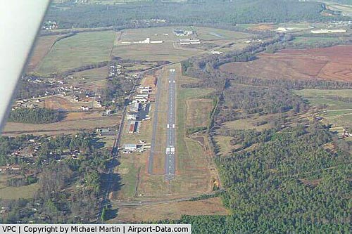 |
(Click on the photo to enlarge) |
|
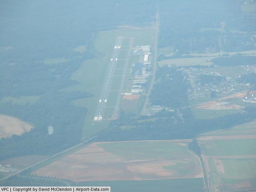 |
(Click on the photo to enlarge) |
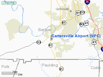
Location
& QuickFacts
|
FAA Information Effective: |
2007-01-18 |
|
Airport
Identifier: |
VPC |
|
Airport
Status: |
Operational |
|
Longitude/Latitude: |
084-50-55.3000W/34-07-23.3000N
-84.848694/34.123139 (Estimated) |
|
Elevation: |
759 ft / 231.34 m (Surveyed) |
|
Land: |
185 acres |
|
From
nearest city: |
3 nautical miles SW of Cartersville, GA |
|
Location: |
Bartow County, GA |
|
Magnetic Variation: |
04W (2005) |
Owner
& Manager
|
Ownership: |
Publicly owned |
|
Owner: |
Cartsvl Bartow Arpt Auth |
|
Address: |
Po Box 323
Cartersville, GA 30120 |
|
Phone
number: |
770-382-1822 |
|
Manager: |
Don Mcmillan
CHAIRMAN ARPT AUTH. |
|
Address: |
Po Box 323
Cartersville, GA 30120 |
|
Phone number: |
770-382-1822
FBO PHONE NUMBER 770-382-9800. |
Airport
Operations and Facilities
|
Airport Use: |
Open to public |
|
Wind
indicator: |
Yes |
|
Segmented
Circle: |
No |
|
Control
Tower: |
No |
|
Lighting
Schedule: |
DUSK-DAWN
HIRL RY 01/19, PAPI RYS 01 & 19 AND REIL RY 19 OPER
DUSK-2200; AFT 2200 ACTVT - CTAF. |
|
Beacon
Color: |
Clear-Green (lighted land airport) |
|
Landing
fee charge: |
No |
|
Sectional
chart: |
Atlanta |
|
Region: |
ASO - Southern |
|
Boundary
ARTCC: |
ZTL - Atlanta |
|
Tie-in
FSS: |
MCN - Macon |
|
FSS
on Airport: |
No |
|
FSS
Phone: |
478-784-1155 |
|
FSS
Toll Free: |
1-800-WX-BRIEF |
|
NOTAMs
Facility: |
VPC (NOTAM-d service avaliable) |
|
Federal Agreements: |
NGY |
Airport
Communications
|
CTAF: |
123.050 |
|
Unicom: |
123.050 |
Airport
Services
|
Fuel available: |
100LLA1+ |
|
Airframe Repair: |
MAJOR |
|
Power Plant Repair: |
MAJOR |
|
Bottled
Oxygen: |
LOW |
|
Bulk
Oxygen: |
NONE |
|
Runway Information
Runway 01/19
|
Dimension: |
5760 x 100 ft / 1755.6 x 30.5 m |
|
Surface: |
ASPH, Good Condition |
|
Surface
Treatment: |
Saw-cut or plastic Grooved |
|
Weight
Limit: |
Single wheel: 26000 lbs. |
|
Edge
Lights: |
High |
|
|
Runway 01 |
Runway 19 |
|
Longitude: |
084-50-57.4267W |
084-50-53.2614W |
|
Latitude: |
34-06-54.8950N |
34-07-51.7668N |
|
Elevation: |
758.00
ft |
730.00
ft |
|
Alignment: |
3 |
127 |
|
ILS
Type: |
|
LOC/DME |
|
Traffic
Pattern: |
Left |
Left |
|
Markings: |
Non-precision instrument, Good Condition |
Non-precision instrument, Good Condition |
|
Crossing
Height: |
38.00
ft |
0.00
ft |
|
Displaced
threshold: |
740.00
ft |
0.00
ft |
|
VASI: |
2-light PAPI on left side |
2-light PAPI on left side |
|
Visual
Glide Angle: |
3.00° |
0.00° |
|
Runway
End Identifier: |
|
Yes |
|
Obstruction: |
46 ft trees, 660.0 ft from runway, 300 ft right
of centerline, 10:1 slope to clear
APPPROACH SLOPE IS 25:1 TO DISPLACED THRESHOLD. |
25 ft brush, 200.0 ft from runway, 160 ft left
of centerline
RWY 19 RY 19 HAS +25 FT TREES & BRUSH 160 FT LEFT OF THRESHOLD. |
|
Radio Navigation
Aids
|
ID |
Type |
Name |
Ch |
Freq |
Var |
Dist |
|
EVZ |
NDB |
Cartersville |
|
308.00 |
04W |
4.6 nm |
|
OUK |
NDB |
Calhoun |
|
323.00 |
02W |
17.2 nm |
|
OYD |
NDB |
Floyd |
|
388.00 |
02W |
18.9 nm |
|
DJD |
NDB |
Canton |
|
415.00 |
04W |
19.6 nm |
|
FT |
NDB |
Flanc |
|
344.00 |
02W |
24.1 nm |
|
JZP |
NDB |
Pickens County |
|
285.00 |
04W |
27.8 nm |
|
GPQ |
NDB |
Carrollton |
|
278.00 |
02W |
36.3 nm |
|
BR |
NDB |
Redan |
|
266.00 |
02W |
39.3 nm |
|
UWI |
NDB |
Whitfield |
|
400.00 |
03W |
40.3 nm |
|
FKV |
NDB |
Flowery Branch |
|
365.00 |
03W |
47.1 nm |
|
FTP |
NDB |
Fort Payne |
|
426.00 |
01W |
47.4 nm |
|
DOB |
TACAN |
Dobbins |
077X |
|
01W |
21.1 nm |
|
PDK |
VOR/DME |
Peachtree |
113X |
116.60 |
02W |
31.2 nm |
|
RMG |
VORTAC |
Rome |
101X |
115.40 |
01E |
13.7 nm |
|
ATL |
VORTAC |
Atlanta |
116X |
116.90 |
00W |
36.2 nm |
|
ATL |
VOT |
Atlanta Muni |
|
111.00 |
|
35.0 nm |
Remarks
- ULTRALIGHT
ACTIVITY ON AND INVOF ARPT.
- DEER
ON & INVOF ARPT.
- ULTRALIGHT
TFC PAT INSIDE NORMAL PAT WITH CENTRAL THIRD OF RY 01/19 DSGND ULTRALIGHT
LNDG & TKOF AREA. ULTRALIGHT PAT ENTRY CROSSES FIELD APRXLY 2000
FT FROM EITHER APCH END AT 541 FT AGL.
- PILOTS
ARE ADVISED TO USE RY 19 WHEN TAILWIND COMPONENT IS 5 KNOTS OR LESS.
WHEN CLIMB PERFORMANCE DICTATES USE OF RY 01, ADVISE ON UNICOM/CTAF
THAT TAKEOFF WILL BE AGAINST TRAFFIC.
- GCO
AVBL ON FREQ 121.725 THRU A80 CLNC DELIVERY AND MACON AFSS.
- BE
ADVISED - GRASS STRIP 4.9 NW OF ARPT.
Based
Aircraft
|
Aircraft
based on field: |
149 |
|
Single
Engine Airplanes: |
88 |
|
Multi
Engine Airplanes: |
29 |
|
Jet Engine
Airplanes: |
18 |
|
Helicopters: |
3 |
|
Ultralights: |
11 |
Operational Statistics
Time Period: 2004-07-16 - 2005-07-15
|
Aircraft
Operations: |
177/Day |
|
Air Taxi: |
7.8% |
|
General
Aviation Local: |
46.5% |
|
General
Aviation Itinerant: |
43.4% |
|
Military: |
2.3% |
Cartersville Airport
Address:
Bartow County, GA
Tel:
770-382-1822
Images
and information placed above are from
http://www.airport-data.com/airport/VPC/
We
thank them for the data!
| General
Info |
| Country |
United
States |
| State |
GEORGIA
|
| FAA ID |
VPC
|
| Latitude |
34-07-23.300N
|
| Longitude |
084-50-55.300W
|
| Elevation |
759 feet
|
| Near City |
CARTERSVILLE
|
We don't guarantee the information is fresh and accurate. The data may
be wrong or outdated.
For more up-to-date information please refer to other sources.
|
|


