 |
|
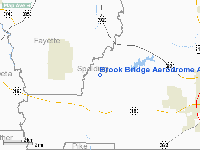
Brook Bridge Aerodrome Airport |
Location
& QuickFacts
|
FAA Information Effective: |
2007-01-18 |
|
Airport
Identifier: |
8GA9 |
|
Airport
Status: |
Operational |
|
Longitude/Latitude: |
084-24-38.7290W/33-16-36.4230N
-84.410758/33.276784 (Estimated) |
|
Elevation: |
820 ft / 249.94 m (Estimated) |
|
Land: |
0 acres |
|
From
nearest city: |
2 nautical miles W of Vaughn, GA |
|
Location: |
Spalding County, GA |
|
Magnetic Variation: |
02W (1985) |
Owner
& Manager
|
Ownership: |
Privately owned |
|
Owner: |
Brook Bridge Homeowners Assn |
|
Address: |
126 Huff Daland Circle
Griffin, GA 30223 |
|
Phone
number: |
404-227-0275 |
|
Manager: |
Brook Bridge Homeowners Assn |
|
Address: |
126 Huff Daland Circle
Griffin, GA 30223 |
|
Phone number: |
404-227-0275 |
Airport
Operations and Facilities
|
Airport Use: |
Private |
|
Wind
indicator: |
Yes |
|
Segmented
Circle: |
Yes |
|
Control
Tower: |
No |
|
Landing
fee charge: |
No |
|
Sectional
chart: |
Atlanta |
|
Region: |
ASO - Southern |
|
Boundary
ARTCC: |
ZTL - Atlanta |
|
Tie-in
FSS: |
MCN - Macon |
|
FSS
on Airport: |
No |
|
FSS
Phone: |
478-784-1155 |
|
FSS
Toll Free: |
1-800-WX-BRIEF |
|
Runway Information
Runway 02/20
|
Dimension: |
2970 x 150 ft / 905.3 x 45.7 m |
|
Surface: |
TURF, |
|
|
Runway 02 |
Runway 20 |
|
Traffic
Pattern: |
Left |
Right |
|
Radio Navigation
Aids
|
ID |
Type |
Name |
Ch |
Freq |
Var |
Dist |
|
FF |
NDB |
Pecat |
|
316.00 |
02W |
4.1 nm |
|
JHH |
NDB |
Griffin |
|
412.00 |
04W |
10.8 nm |
|
EQQ |
NDB |
Coweta County |
|
234.00 |
03W |
15.2 nm |
|
BR |
NDB |
Redan |
|
266.00 |
02W |
22.7 nm |
|
OP |
NDB |
Yates |
|
339.00 |
03W |
24.3 nm |
|
FT |
NDB |
Flanc |
|
344.00 |
02W |
31.3 nm |
|
PIM |
NDB |
Pine Mountain |
|
272.00 |
03W |
34.9 nm |
|
VOF |
NDB |
Alcovy |
|
370.00 |
03W |
38.0 nm |
|
GPQ |
NDB |
Carrollton |
|
278.00 |
02W |
40.1 nm |
|
JNM |
NDB |
Monroe |
|
392.00 |
03W |
44.1 nm |
|
DOB |
TACAN |
Dobbins |
077X |
|
01W |
38.6 nm |
|
PDK |
VOR/DME |
Peachtree |
113X |
116.60 |
02W |
36.4 nm |
|
ATL |
VORTAC |
Atlanta |
116X |
116.90 |
00W |
21.2 nm |
|
LGC |
VORTAC |
Lagrange |
103X |
115.60 |
01E |
42.3 nm |
|
ATL |
VOT |
Atlanta Muni |
|
111.00 |
|
22.9 nm |
Remarks
- VFR;
PRIVATE USE ONLY; TRAFFIC PATTERN ESTABLISHED NW OF RWY; MAINTAIN COMPATIBLE
OPERATIONS AGREEMENT WITH OPERATOR OF CEDAR RIDGE ARPT.
Based
Aircraft
|
Aircraft
based on field: |
22 |
|
Single
Engine Airplanes: |
22 |
Brook Bridge Aerodrome Airport
Address:
Spalding County, GA
Tel:
404-227-0275
Images
and information placed above are from
http://www.airport-data.com/airport/8GA9/
We
thank them for the data!
| General
Info |
| Country |
United
States |
| State |
GEORGIA
|
| FAA ID |
8GA9
|
| Latitude |
33-16-36.423N
|
| Longitude |
084-24-38.729W
|
| Elevation |
820 feet
|
| Near City |
VAUGHN
|
We don't guarantee the information is fresh and accurate. The data may
be wrong or outdated.
For more up-to-date information please refer to other sources.
|
|


