|
|
|
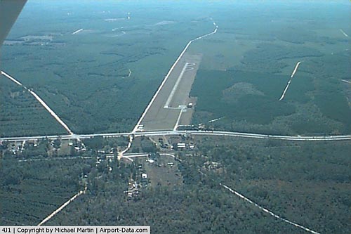 |
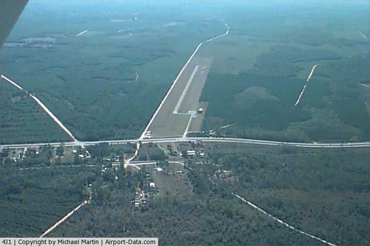
(Click on the photo to enlarge) |
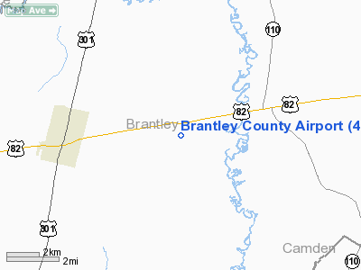
Location
& QuickFacts
|
FAA Information Effective: |
2007-01-18 |
|
Airport
Identifier: |
4J1 |
|
Airport
Status: |
Operational |
|
Longitude/Latitude: |
081-54-20.9300W/31-12-26.7600N
-81.905814/31.207433 (Estimated) |
|
Elevation: |
83 ft / 25.30 m (Surveyed) |
|
Land: |
59 acres |
|
From
nearest city: |
4 nautical miles E of Nahunta, GA |
|
Location: |
Brantley County, GA |
|
Magnetic Variation: |
04W (1995) |
Owner
& Manager
|
Ownership: |
Publicly owned |
|
Owner: |
Brantley County |
|
Address: |
Po Box 398, 117 Brantly Street
Nahunta, GA 31553 |
|
Phone
number: |
912-462-5256 |
|
Manager: |
Terry Thomas
CHAIRMAN, COUNTY COMMISSION. |
|
Address: |
Po Box 398, 117 Brantly Street
Nahunta, GA 31553 |
|
Phone number: |
912-462-5256 |
Airport
Operations and Facilities
|
Airport Use: |
Open to public |
|
Wind
indicator: |
Yes |
|
Segmented
Circle: |
Yes |
|
Control
Tower: |
No |
|
Landing
fee charge: |
No |
|
Sectional
chart: |
Jacksonville |
|
Region: |
ASO - Southern |
|
Boundary
ARTCC: |
ZJX - Jacksonville |
|
Tie-in
FSS: |
MCN - Macon |
|
FSS
on Airport: |
No |
|
FSS
Phone: |
478-784-1155 |
|
FSS
Toll Free: |
1-800-WX-BRIEF |
|
NOTAMs
Facility: |
MCN (NOTAM-d service avaliable) |
|
Federal Agreements: |
NY1 |
Airport
Communications
Airport
Services
|
Airframe Repair: |
NONE |
|
Power Plant Repair: |
NONE |
|
Bottled
Oxygen: |
NONE |
|
Bulk
Oxygen: |
NONE |
|
Runway Information
Runway 01/19
|
Dimension: |
3000 x 50 ft / 914.4 x 15.2 m |
|
Surface: |
ASPH, Poor Condition
RY 01/19 PAVEMENT SEVERLY OXIDIZED AND CRACKED. |
|
Weight
Limit: |
Single wheel: 14000 lbs. |
|
|
Runway 01 |
Runway 19 |
|
Alignment: |
6 |
127 |
|
Traffic
Pattern: |
Left |
Left |
|
Markings: |
Basic, Fair Condition |
Basic, Fair Condition |
|
Obstruction: |
55 ft trees, 1190.0 ft from runway, 175 ft
left of centerline, 18:1 slope to clear |
54 ft trees, 1280.0 ft from runway, 20:1 slope
to clear |
|
Radio Navigation
Aids
|
ID |
Type |
Name |
Ch |
Freq |
Var |
Dist |
|
JES |
NDB |
Slover |
|
340.00 |
04W |
20.8 nm |
|
JUK |
NDB |
Mc Kinnon |
|
353.00 |
05W |
26.7 nm |
|
BHC |
NDB |
Baxley |
|
376.00 |
04W |
39.2 nm |
|
MOQ |
NDB |
Mc Intosh |
|
263.00 |
04W |
42.6 nm |
|
JA |
NDB |
Dinns |
|
344.00 |
03W |
44.9 nm |
|
HOE |
NDB |
Homerville |
|
209.00 |
03W |
45.5 nm |
|
EYA |
NDB |
Eastport |
|
357.00 |
03W |
49.5 nm |
|
SSI |
VORTAC |
Brunswick |
035X |
109.80 |
04W |
25.5 nm |
|
AYS |
VORTAC |
Waycross |
039X |
110.20 |
00E |
33.6 nm |
|
AMG |
VORTAC |
Alma |
098X |
115.10 |
00E |
36.7 nm |
|
BQK |
VOT |
Brunswick |
|
111.00 |
|
23.4 nm |
|
JAX |
VOT |
Jacksonville Intl |
|
111.00 |
|
44.4 nm |
Based
Aircraft
|
Aircraft
based on field: |
2 |
|
Single
Engine Airplanes: |
2 |
Operational Statistics
Time Period: 2005-02-03 - 2006-02-02
|
Aircraft
Operations: |
20/Week |
|
General
Aviation Local: |
50.0% |
|
General
Aviation Itinerant: |
50.0% |
Brantley County Airport
Address:
Brantley County, GA
Tel:
912-462-5256
Images
and information placed above are from
http://www.airport-data.com/airport/4J1/
We
thank them for the data!
| General
Info |
| Country |
United
States |
| State |
GEORGIA
|
| FAA ID |
4J1
|
| Latitude |
31-12-45.807N
|
| Longitude |
081-54-19.407W
|
| Elevation |
83 feet
|
| Near City |
NAHUNTA
|
We don't guarantee the information is fresh and accurate. The data may
be wrong or outdated.
For more up-to-date information please refer to other sources.
|
|