 |
|
|
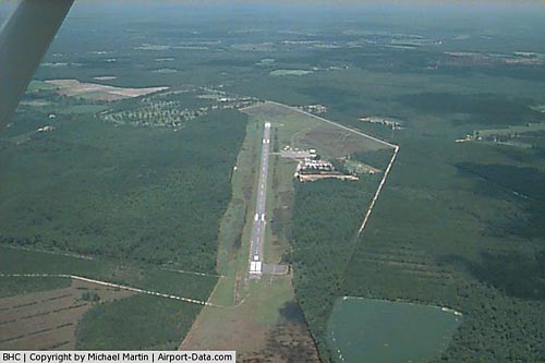 |
(Click on the photo to enlarge) |
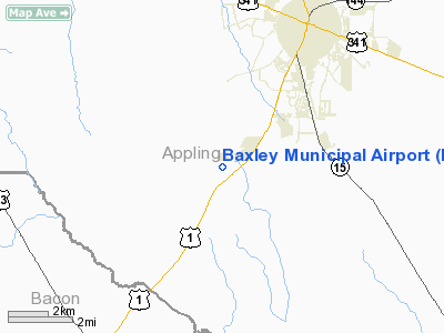
Location
& QuickFacts
|
FAA Information Effective: |
2007-01-18 |
|
Airport
Identifier: |
BHC |
|
Airport
Status: |
Operational |
|
Longitude/Latitude: |
082-23-37.6000W/31-42-49.8000N
-82.393778/31.713833 (Estimated) |
|
Elevation: |
201 ft / 61.26 m (Surveyed) |
|
Land: |
303 acres |
|
From
nearest city: |
4 nautical miles S of Baxley, GA |
|
Location: |
Appling County, GA |
|
Magnetic Variation: |
04W (1995) |
Owner
& Manager
|
Ownership: |
Publicly owned |
|
Owner: |
City Of Baxley |
|
Address: |
City Hall, Po Box 180
Baxley, GA 31513 |
|
Phone
number: |
912-367-8300 |
|
Manager: |
Jeff Baxley, City Mgr |
|
Address: |
City Hall, Po Box 180
Baxley, GA 31513 |
|
Phone number: |
912-367-8300 |
Airport
Operations and Facilities
|
Airport Use: |
Open to public |
|
Wind
indicator: |
Yes |
|
Segmented
Circle: |
Yes |
|
Control
Tower: |
No |
|
Lighting
Schedule: |
DUSK-2200
AFTER 2200, ACTVT ROTG BCN - CTAF. |
|
Beacon
Color: |
Clear-Green (lighted land airport) |
|
Landing
fee charge: |
No |
|
Sectional
chart: |
Jacksonville |
|
Region: |
ASO - Southern |
|
Traffic
Pattern Alt: |
1000 ft |
|
Boundary
ARTCC: |
ZJX - Jacksonville |
|
Tie-in
FSS: |
MCN - Macon |
|
FSS
on Airport: |
No |
|
FSS
Phone: |
478-784-1155 |
|
FSS
Toll Free: |
1-800-WX-BRIEF |
|
NOTAMs
Facility: |
MCN (NOTAM-d service avaliable) |
|
Federal Agreements: |
NGY |
Airport
Communications
|
CTAF: |
122.800 |
|
Unicom: |
122.800 |
Airport
Services
|
Fuel available: |
100LLA
24 HR SELF-SERVE, CREDIT CARD FUEL AVBL. |
|
Airframe Repair: |
MAJOR |
|
Power Plant Repair: |
MAJOR |
|
Bottled
Oxygen: |
NONE |
|
Bulk
Oxygen: |
NONE |
|
Runway Information
Runway 08/26
|
Dimension: |
5003 x 75 ft / 1524.9 x 22.9 m |
|
Surface: |
ASPH, Fair Condition |
|
Weight
Limit: |
Single wheel: 19000 lbs. |
|
Edge
Lights: |
Medium |
|
|
Runway 08 |
Runway 26 |
|
Longitude: |
082-24-05.5877W |
082-23-09.6733W |
|
Latitude: |
31-42-43.3696N |
31-42-56.2935N |
|
Elevation: |
200.00
ft |
201.00
ft |
|
Alignment: |
75 |
127 |
|
Traffic
Pattern: |
Left |
Left |
|
Markings: |
Non-precision instrument, Fair Condition |
Non-precision instrument, Fair Condition |
|
Crossing
Height: |
31.00
ft |
31.00
ft |
|
VASI: |
2-light PAPI on left side |
2-light PAPI on left side |
|
Visual
Glide Angle: |
3.00° |
3.00° |
|
Runway
End Identifier: |
No |
No |
|
Obstruction: |
79 ft trees, 2175.0 ft from runway, 25:1 slope
to clear
RY 08 +20 FT TREES 214 FT L OF RY CNTRLN, 100 TO 1000 FT FROM
THLD. |
88 ft trees, 1784.0 ft from runway, 100 ft
right of centerline, 18:1 slope to clear
+15 FT TREES AND BRUSH 120 FT R OF THLD EXTENDING OUT 300
FT. |
|
Radio Navigation
Aids
|
ID |
Type |
Name |
Ch |
Freq |
Var |
Dist |
|
BHC |
NDB |
Baxley |
|
376.00 |
04W |
0.2 nm |
|
AZE |
NDB |
Hazlehurst |
|
414.00 |
03W |
16.4 nm |
|
RVJ |
NDB |
Prison |
|
424.00 |
03W |
24.1 nm |
|
JES |
NDB |
Slover |
|
340.00 |
04W |
27.7 nm |
|
UQN |
NDB |
Onyun |
|
372.00 |
04W |
31.0 nm |
|
OWC |
NDB |
Coffee County |
|
390.00 |
03W |
32.9 nm |
|
MQW |
NDB |
Mc Rae |
|
280.00 |
03W |
33.9 nm |
|
CWV |
NDB |
Claxton |
|
395.50 |
04W |
39.1 nm |
|
MHP |
NDB |
Metter |
|
432.00 |
03W |
42.6 nm |
|
HOE |
NDB |
Homerville |
|
209.00 |
03W |
44.1 nm |
|
MOQ |
NDB |
Mc Intosh |
|
263.00 |
04W |
45.7 nm |
|
EZM |
NDB |
Eastman |
|
366.00 |
04W |
46.3 nm |
|
SUR |
NDB |
Fitzgerald |
|
362.00 |
03W |
46.3 nm |
|
AMG |
VORTAC |
Alma |
098X |
115.10 |
00E |
12.2 nm |
|
AYS |
VORTAC |
Waycross |
039X |
110.20 |
00E |
28.0 nm |
Based
Aircraft
|
Aircraft
based on field: |
19 |
|
Single
Engine Airplanes: |
16 |
|
Multi
Engine Airplanes: |
1 |
|
Ultralights: |
2 |
Operational Statistics
Time Period: 2005-03-08
- 2006-03-07
|
Aircraft
Operations: |
225/Week |
|
General
Aviation Local: |
47.0% |
|
General
Aviation Itinerant: |
53.0% |
Baxley Municipal Airport
Address:
Appling County, GA
Tel:
912-367-8300
Images
and information placed above are from
http://www.airport-data.com/airport/BHC/
We
thank them for the data!
| General
Info |
| Country |
United
States |
| State |
GEORGIA
|
| FAA ID |
BHC
|
| Latitude |
31-42-49.800N
|
| Longitude |
082-23-37.600W
|
| Elevation |
201 feet
|
| Near City |
BAXLEY
|
We don't guarantee the information is fresh and accurate. The data may
be wrong or outdated.
For more up-to-date information please refer to other sources.
|
|


