 |
|
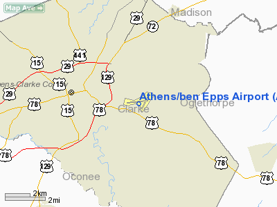
Athens / ben Epps Airport |
| Athens-Ben Epps Airport |
| IATA: AHN â ICAO: KAHN â FAA LID: AHN |
| Summary |
| Airport type |
Public |
| Owner |
Clarke County |
| Serves |
Athens, Georgia |
| Elevation AMSL |
808 ft / 246 m |
| Coordinates |
33°56â²55â³N 083°19â²35â³W / 33.94861°N 83.32639°W / 33.94861; -83.32639 |
| Website |
www.AthensAirport.net |
| Runways |
| Direction |
Length |
Surface |
| ft |
m |
| 9/27 |
5,522 |
1,683 |
Asphalt |
| 2/20 |
4,000 |
1,219 |
Asphalt |
| Statistics (2007) |
| Aircraft operations |
53,357 |
| Based aircraft |
126 |
| Source: Federal Aviation Administration |
Athens-Ben Epps Airport (IATA: AHN, ICAO: KAHN, FAA LID: AHN) is a county-owned public-use airport located three nautical miles (6 km) east of the central business district of Athens, in Clarke County, Georgia, United States. It is mostly used for general aviation. The airport is named after Ben T. Epps, the first aviator in the state of Georgia, who opened the airport in 1917.
Until May 23, 2008, the airport was served by twice-daily flights to Charlotte on Air Midwest operating as US Airways Express. It is now served by daily flights to Atlanta and Macon by GeorgiaSkies. Wings Air covered the same routes but closed after only a few months in business. Wings Air added a check-in counter in the western end of the terminal, and it is now vacant. GeorgiaSkies took over the USAirways Express counter and security area.
Falcon Aviation Academy is the only flight school. Facilities and aircraft
Athens-Ben Epps Airport covers an area of 425 acres (172 ha) at an elevation of 808 feet (246 m) above mean sea level. It has two asphalt paved runways: 9/27 measuring 5,522 by 100 feet (1,683 x 30 m) and 2/20 measuring 4,000 by 100 feet (1,219 x 30 m).
For the 12-month period ending July 31, 2007, the airport had 53,357 aircraft operations, an average of 146 per day: 90% general aviation, 6% military, 3% air taxi and <1% scheduled commercial. At that time there were 126 aircraft based at this airport: 56% single-engine, 29% multi-engine, 13% jet and 2% helicopter.
Airlines and destinations
Scheduled passenger service
- Georgia Skies (Atlanta , Nashville)
- Wings Air (USA) (Atlanta)
The above content comes from Wikipedia and is published under free licenses – click here to read more.
|
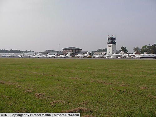 |
(Click on the photo to enlarge) |
|
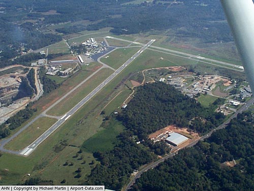 |
(Click on the photo to enlarge) |
Location
& QuickFacts
|
FAA Information Effective: |
2007-01-18 |
|
Airport
Identifier: |
AHN |
|
Airport
Status: |
Operational |
|
Longitude/Latitude: |
083-19-34.8490W/33-56-54.9430N
-83.326347/33.948595 (Estimated) |
|
Elevation: |
808 ft / 246.28 m (Surveyed) |
|
Land: |
425 acres |
|
From
nearest city: |
3 nautical miles E of Athens, GA |
|
Location: |
Clarke County, GA |
|
Magnetic Variation: |
03W (1985) |
Owner
& Manager
|
Ownership: |
Publicly owned |
|
Owner: |
Clarke County |
|
Address: |
Po Box 448, Co Courthouse
Athens, GA 30601 |
|
Phone
number: |
706-613-3420 |
|
Manager: |
Tim Beggerly |
|
Address: |
1010 Ben Epps Drive
Athens, GA 30605 |
|
Phone number: |
706-613-3416 |
Airport
Operations and Facilities
|
Airport Use: |
Open to public |
|
Wind
indicator: |
Yes |
|
Segmented
Circle: |
Yes |
|
Control
Tower: |
Yes |
|
Lighting
Schedule: |
DUSK-DAWN
ACTVT PAPI RYS 09 & 20, REIL RY 27 & ODALS RY 27
- CTAF. WHEN ATCT CLSD MIRL RY 09/27 PRESET LOW INTST; TO
INCREASE INTST ACTVT - CTAF. |
|
Beacon
Color: |
Clear-Green (lighted land airport) |
|
Landing
fee charge: |
No |
|
Sectional
chart: |
Atlanta |
|
Region: |
ASO - Southern |
|
Boundary
ARTCC: |
ZTL - Atlanta |
|
Tie-in
FSS: |
MCN - Macon |
|
FSS
on Airport: |
No |
|
FSS
Phone: |
478-784-1155 |
|
FSS
Toll Free: |
1-800-WX-BRIEF |
|
NOTAMs
Facility: |
AHN (NOTAM-d service avaliable) |
|
Certification
type/date: |
I A S 02/1985
CLSD TO UNSKED ACR OPNS WITH MORE THAN 30 PSGR SEATS EXCP
24 HRS PPR CALL AMGR 706-613-3420. INDEX B AIRCRAFT RESCUE
AND FIRE FIGHTING EQUIPMENT IS AVAILABLE. |
|
Federal Agreements: |
NGY3 |
Airport
Communications
|
CTAF: |
126.300 |
|
Unicom: |
122.950 |
Airport
Services
|
Fuel available: |
100LLA1 |
|
Airframe Repair: |
MAJOR |
|
Power Plant Repair: |
MAJOR |
|
Bottled
Oxygen: |
NONE |
|
Bulk
Oxygen: |
NONE |
|
Runway Information
Runway 02/20
|
Dimension: |
4000 x 100 ft / 1219.2 x 30.5 m |
|
Surface: |
ASPH, Good Condition |
|
Weight
Limit: |
Single wheel: 40000 lbs.
Dual wheel: 45000 lbs. |
|
Edge
Lights: |
Medium |
|
|
Runway 02 |
Runway 20 |
|
Longitude: |
083-19-29.5480W |
083-19-12.6940W |
|
Latitude: |
33-56-33.7630N |
33-57-10.7560N |
|
Elevation: |
775.00
ft |
803.00
ft |
|
Alignment: |
21 |
127 |
|
Traffic
Pattern: |
Left |
Left |
|
Markings: |
Non-precision instrument, Fair Condition |
Non-precision instrument, Fair Condition |
|
Crossing
Height: |
43.00
ft |
0.00 ft |
|
VASI: |
4-box on left side |
4-light PAPI on left side |
|
Visual
Glide Angle: |
3.75° |
0.00° |
|
Obstruction: |
72 ft trees, 1500.0 ft from runway, 150 ft
left of centerline, 20:1 slope to clear |
63 ft trees, 1475.0 ft from runway, 250 ft
right of centerline, 20:1 slope to clear |
|
Runway 09/27
|
Dimension: |
5522 x 100 ft / 1683.1 x 30.5 m |
|
Surface: |
ASPH, Good Condition |
|
Surface
Treatment: |
Saw-cut or plastic Grooved |
|
Weight
Limit: |
Single wheel: 65000 lbs.
Dual wheel: 125000 lbs. |
|
Edge
Lights: |
Medium |
|
|
Runway 09 |
Runway 27 |
|
Longitude: |
083-20-17.5500W |
083-19-12.0340W |
|
Latitude: |
33-56-56.0810N |
33-56-57.6890N |
|
Elevation: |
755.00
ft |
808.00
ft |
|
Alignment: |
88 |
127 |
|
ILS
Type: |
|
LOC/GS |
|
Traffic
Pattern: |
Left |
Left |
|
Markings: |
Non-precision instrument, Good Condition |
Precision instrument, |
|
Crossing
Height: |
39.00
ft |
34.00
ft |
|
VASI: |
4-light PAPI on left side |
4-box on left side |
|
Visual
Glide Angle: |
3.00° |
3.00° |
|
Approach
lights: |
|
ODALS |
|
Runway
End Identifier: |
|
Yes |
|
Radio Navigation
Aids
|
ID |
Type |
Name |
Ch |
Freq |
Var |
Dist |
|
BJT |
NDB |
Bulldog |
|
221.00 |
03W |
5.3 nm |
|
DDA |
NDB |
Commerce |
|
244.00 |
03W |
11.9 nm |
|
BMW |
NDB |
Barrow County |
|
404.00 |
03W |
13.1 nm |
|
JNM |
NDB |
Monroe |
|
392.00 |
03W |
23.7 nm |
|
VV |
NDB |
Junne |
|
353.00 |
05W |
23.7 nm |
|
IIY |
NDB |
Washington/wilkes County |
|
435.00 |
03W |
27.7 nm |
|
VOF |
NDB |
Alcovy |
|
370.00 |
03W |
29.8 nm |
|
FKV |
NDB |
Flowery Branch |
|
365.00 |
03W |
32.7 nm |
|
AJR |
NDB |
Habersham |
|
347.00 |
03W |
35.0 nm |
|
AA |
NDB |
Cedar |
|
341.00 |
04W |
43.5 nm |
|
AND |
NDB |
Anderson County |
|
230.00 |
04W |
45.1 nm |
|
HQU |
NDB |
Thomson-mcduffie |
|
333.00 |
04W |
47.8 nm |
|
UMB |
NDB |
Culvr |
|
380.00 |
04W |
48.6 nm |
|
CEU |
NDB |
Clemson |
|
257.00 |
05W |
48.7 nm |
|
PDK |
VOR/DME |
Peachtree |
113X |
116.60 |
02W |
48.7 nm |
|
AHN |
VORTAC |
Athens |
33 |
109.60 |
00E |
0.1 nm |
|
ELW |
VORTAC |
Electric City |
023X |
108.60 |
00E |
39.1 nm |
|
ODF |
VORTAC |
Foothills |
081X |
113.40 |
00E |
44.9 nm |
Remarks
- NOISE
SENSITIVE AREA S OF ARPT; CTC FBO FOR INFORMATION.
- RY
02/20 NON-AIR CARRIER ONLY.
Based
Aircraft
|
Aircraft
based on field: |
125 |
|
Single
Engine Airplanes: |
70 |
|
Multi
Engine Airplanes: |
37 |
|
Jet Engine
Airplanes: |
17 |
|
Helicopters: |
1 |
Operational Statistics
Time Period: 2005-08-01
- 2006-07-31
|
Aircraft
Operations: |
201/Day |
|
Commerical: |
0.1% |
|
Air Taxi: |
2.6% |
|
General
Aviation Local: |
52.5% |
|
General
Aviation Itinerant: |
40.2% |
|
Military: |
4.6% |
Athens/ben Epps Airport
Address:
Clarke County, GA
Tel:
706-613-3420,
706-613-3416
Images
and information placed above are from
http://www.airport-data.com/airport/AHN/
We
thank them for the data!
| General
Info |
| Country |
United
States |
| State |
GEORGIA
|
| FAA ID |
AHN
|
| Latitude |
33-56-54.943N
|
| Longitude |
083-19-34.849W
|
| Elevation |
808 feet
|
| Near City |
ATHENS
|
We don't guarantee the information is fresh and accurate. The data may
be wrong or outdated.
For more up-to-date information please refer to other sources.
|
|


