 |
|
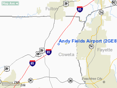
Location
& QuickFacts
|
FAA Information Effective: |
2007-01-18 |
|
Airport
Identifier: |
2GE8 |
|
Airport
Status: |
Operational |
|
Longitude/Latitude: |
084-39-48.0000W/33-27-51.0000N
-84.663333/33.464167 (Estimated) |
|
Elevation: |
980 ft / 298.70 m (Estimated) |
|
Land: |
8
acres |
|
From
nearest city: |
7 nautical miles N of Newnan, GA |
|
Location: |
Coweta County, GA |
|
Magnetic Variation: |
03W (1995) |
Owner
& Manager
|
Ownership: |
Privately owned |
|
Owner: |
James H. Fields |
|
Address: |
3099 Fisher Road
Newnan, GA 30265 |
|
Phone
number: |
404-463-3159 |
|
Manager: |
James H. Fields |
|
Address: |
3099 Fisher Road
Newnan, GA 30265 |
|
Phone number: |
404-463-3159 |
Airport
Operations and Facilities
|
Airport Use: |
Private |
|
Wind
indicator: |
Yes |
|
Segmented
Circle: |
No |
|
Control
Tower: |
No |
|
Sectional
chart: |
Atlanta |
|
Region: |
ASO - Southern |
|
Boundary
ARTCC: |
ZTL - Atlanta |
|
Tie-in
FSS: |
MCN - Macon |
|
FSS
Phone: |
478-784-1155 |
|
FSS
Toll Free: |
1-800-WX-BRIEF |
|
Runway Information
Runway N/S
|
Dimension: |
1500 x 75 ft / 457.2 x 22.9 m |
|
Surface: |
TURF, Good Condition |
|
|
Runway N |
Runway S |
|
Traffic
Pattern: |
Left |
Left |
|
Obstruction: |
|
15 ft trees, 400.0 ft from runway |
|
Radio Navigation
Aids
|
ID |
Type |
Name |
Ch |
Freq |
Var |
Dist |
|
EQQ |
NDB |
Coweta County |
|
234.00 |
03W |
12.7 nm |
|
FF |
NDB |
Pecat |
|
316.00 |
02W |
13.2 nm |
|
FT |
NDB |
Flanc |
|
344.00 |
02W |
18.0 nm |
|
BR |
NDB |
Redan |
|
266.00 |
02W |
20.7 nm |
|
GPQ |
NDB |
Carrollton |
|
278.00 |
02W |
24.2 nm |
|
JHH |
NDB |
Griffin |
|
412.00 |
04W |
27.6 nm |
|
PIM |
NDB |
Pine Mountain |
|
272.00 |
03W |
38.8 nm |
|
OP |
NDB |
Yates |
|
339.00 |
03W |
40.6 nm |
|
EVZ |
NDB |
Cartersville |
|
308.00 |
04W |
45.1 nm |
|
VOF |
NDB |
Alcovy |
|
370.00 |
03W |
45.3 nm |
|
DJD |
NDB |
Canton |
|
415.00 |
04W |
48.2 nm |
|
JNM |
NDB |
Monroe |
|
392.00 |
03W |
49.7 nm |
|
DOB |
TACAN |
Dobbins |
077X |
|
01W |
28.2 nm |
|
PDK |
VOR/DME |
Peachtree |
113X |
116.60 |
02W |
30.7 nm |
|
ATL |
VORTAC |
Atlanta |
116X |
116.90 |
00W |
15.1 nm |
|
LGC |
VORTAC |
Lagrange |
103X |
115.60 |
01E |
37.0 nm |
|
RMG |
VORTAC |
Rome |
101X |
115.40 |
01E |
47.8 nm |
|
ATL |
VOT |
Atlanta Muni |
|
111.00 |
|
16.6 nm |
Remarks
- 75
FT WATER TANK 1 NM NORTHEAST OF ARPT.
- PRVDD
VFR/PVT USE.
Based
Aircraft
|
Aircraft
based on field: |
1 |
|
Single
Engine Airplanes: |
1 |
Andy Fields Airport
Address:
Coweta County, GA
Tel:
404-463-3159
Images
and information placed above are from
http://www.airport-data.com/airport/2GE8/
We
thank them for the data!
| General
Info |
| Country |
United
States |
| State |
GEORGIA
|
| FAA ID |
2GE8
|
| Latitude |
33-27-51.000N
|
| Longitude |
084-39-48.000W
|
| Elevation |
980 feet
|
| Near City |
NEWNAN
|
We don't guarantee the information is fresh and accurate. The data may
be wrong or outdated.
For more up-to-date information please refer to other sources.
|
|


