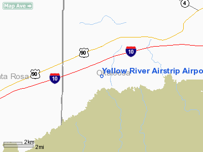
Yellow River Airstrip Airport |
Location
& QuickFacts
|
FAA Information Effective: |
2007-01-18 |
|
Airport
Identifier: |
FD93 |
|
Airport
Status: |
Operational |
|
Longitude/Latitude: |
086-44-49.8420W/30-41-07.6870N
-86.747178/30.685469 (Estimated) |
|
Elevation: |
150 ft / 45.72 m (Estimated) |
|
Land: |
0
acres |
|
From
nearest city: |
2 nautical miles S of Holt, FL |
|
Location: |
Okaloosa County, FL |
|
Magnetic Variation: |
01E (1980) |
Owner
& Manager
|
Ownership: |
Privately owned |
|
Owner: |
Yellow River Arpt Prop Owners |
|
Address: |
7785 White Sands Blvd
Navarre Beach, FL 32566 |
|
Address: |
|
Airport
Operations and Facilities
|
Airport Use: |
Private |
|
Segmented
Circle: |
No |
|
Control
Tower: |
No |
|
Sectional
chart: |
New Orleans |
|
Region: |
ASO - Southern |
|
Boundary
ARTCC: |
ZJX - Jacksonville |
|
Tie-in
FSS: |
GNV - Gainesville |
|
FSS
Phone: |
850-377-3291 |
|
FSS
Toll Free: |
1-800-WX-BRIEF |
|
Runway Information
Runway 09/27
|
Dimension: |
2550 x 200 ft / 777.2 x 61.0 m |
|
Surface: |
TURF, |
|
|
Runway 09 |
Runway 27 |
|
Traffic
Pattern: |
Left |
Left |
|
Radio Navigation
Aids
|
ID |
Type |
Name |
Ch |
Freq |
Var |
Dist |
|
DTS |
NDB |
Destin |
|
254.00 |
01W |
22.0 nm |
|
PKZ |
NDB |
Pickens |
|
326.00 |
01E |
26.9 nm |
|
JUY |
NDB |
Judd |
|
264.00 |
02W |
41.5 nm |
|
NGS |
TACAN |
Santa Rosa |
063X |
|
01E |
10.7 nm |
|
NSE |
TACAN |
Whiting |
070X |
|
01E |
14.2 nm |
|
HRT |
TACAN |
Hurlburt |
045X |
|
00E |
15.8 nm |
|
DWG |
TACAN |
Warrington |
002X |
|
00E |
17.1 nm |
|
NPA |
TACAN |
Pensacola |
119X |
|
01E |
35.4 nm |
|
NUN |
VOR |
Saufley |
|
108.80 |
01E |
33.1 nm |
|
UIA |
VOR |
Andalusia |
|
110.20 |
00E |
41.7 nm |
|
CEW |
VORTAC |
Crestview |
106X |
115.90 |
03E |
9.2 nm |
Remarks
Based Aircraft
|
Aircraft
based on field: |
11 |
|
Single
Engine Airplanes: |
10 |
|
Multi
Engine Airplanes: |
1 |
Yellow River Airstrip Airport
Address:
Okaloosa County, FL
Tel:
Images
and information placed above are from
http://www.airport-data.com/airport/FD93/
We
thank them for the data!
| General
Info |
| Country |
United
States |
| State |
FLORIDA
|
| FAA ID |
FD93
|
| Latitude |
30-41-07.687N
|
| Longitude |
086-44-49.842W
|
| Elevation |
150 feet
|
| Near City |
HOLT
|
We don't guarantee the information is fresh and accurate. The data may
be wrong or outdated.
For more up-to-date information please refer to other sources.
|


