|
|
Coordinates: 27°04′18″N 082°26′25″W / 27.07167°N 82.44028°W / 27.07167; -82.44028
| Venice Municipal Airport |
 |
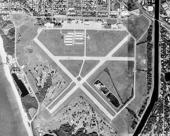
| USGS aerial image, 31 Dec 1998 |
| IATA: VNC – ICAO: KVNC – FAA LID: VNC |
| Summary |
| Airport type |
Public |
| Owner |
City of Venice |
| Serves |
Venice, Florida |
| Elevation AMSL |
18 ft / 5 m |
| Website |
venicegov.com/... |
| Runways |
| Direction |
Length |
Surface |
| ft |
m |
| 4/22 |
5,000 |
1,524 |
Asphalt |
| 13/31 |
5,000 |
1,524 |
Asphalt |
| Statistics (2008) |
| Aircraft operations |
172,645 |
| Based aircraft |
214 |
| Sources: airport web site and FAA |
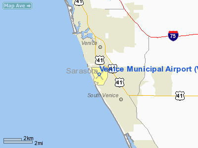
Venice Municipal Airport (IATA: VNC, ICAO: KVNC, FAA LID: VNC) is a city managed public-use airport located two miles (3 km) south of the central business district of Venice, a city in Sarasota County, Florida, United States. History
The airport was built during the 1940s by the United States Army Air Force. It served as a military flight training facility. It also was used by Air Transport Command to deliver US-built aircraft destined for Britain under Lend-lease from the factories on the West Coast or picked British pilots. Some of the aircraft were partially disassembled and prepared for being loaded onboard ships for the trip across the Atlantic Ocean.
After World War II, the U.S. government gave airport control to the City of Venice, naming them airport sponsor through various grant assurances.
After the September 11 attacks of 2001, authorities found out that three of the 9/11 terrorists, Mohamed Atta, Marwan al-Shehhi, and Ziad Jarrah, had all enrolled at the now defunct Huffman Aviation flight training school at the VNC for aviation lessons. [1]
Facilities and aircraft
Venice Municipal Airport covers an area of 1,200 acres (486 ha) which contains two asphalt paved runways: 4/22 and 13/31, both measuring 5,000 x 150 ft (1,524 x 46 m).
For the 12-month period ending October 21, 2008, the airport had 172,645 aircraft operations, an average of 473 per day: 99% general aviation, <1% air taxi and <1% military. At that time there were 214 aircraft based at this airport: 181 single-engine, 28 multi-engine, 3 jet and 2 helicopter.
It is also the base of FFTC (Florida Flight Training Center) that offers pilot training as well as charter service within Florida and the surrounding states.
Suncoast Air Center, located just west of the approach end of Runway 22, is the primary FBO and provides ground support and aviation services to aircraft that use the airfield. They offer both Avgas and JetA fuels, with Avgas available full or self service. 3
Sarasota Avionics International maintains its headquarters in a 10,000 SF hangar on the northwest side of the airport.
There are two restaurants located at the airport: Honoluana, open for lunch and dinner, and the Suncoast Cafe, the latter of which is housed within Suncoast Air Center's FBO terminal and is open for breakfast and lunch.
The above content comes from Wikipedia and is published under free licenses – click here to read more.
Location
& QuickFacts
|
FAA Information Effective: |
2007-01-18 |
|
Airport
Identifier: |
VNC |
|
Airport
Status: |
Operational |
|
Longitude/Latitude: |
082-26-25.2000W/27-04-17.8000N
-82.440333/27.071611 (Estimated) |
|
Elevation: |
18
ft / 5.49 m (Surveyed) |
|
Land: |
1200 acres |
|
From
nearest city: |
2 nautical miles S of Venice, FL |
|
Location: |
Sarasota County, FL |
|
Magnetic Variation: |
02W (1990) |
Owner
& Manager
|
Ownership: |
Publicly owned |
|
Owner: |
City Of Venice |
|
Address: |
401 West Venice Avenue
Venice, FL 34285 |
|
Phone
number: |
941-486-2626 |
|
Manager: |
L A Heath, Jr |
|
Address: |
150 East Airport Avenue
Venice, FL 34285 |
|
Phone number: |
941-486-2711 |
Airport
Operations and Facilities
|
Airport Use: |
Open to public |
|
Wind
indicator: |
Yes |
|
Segmented
Circle: |
No |
|
Control
Tower: |
No |
|
Lighting
Schedule: |
DUSK-DAWN
MIRL RYS 04/22 & 13/31, REIL RYS 04, 22, 13 & 31,
PAPI RYS 04, 22, 13 & 31 AND ODALS RY 31 OPER DUSK-0000.
AFTER
0000 ACTVT - CTAF. |
|
Beacon
Color: |
Clear-Green (lighted land airport) |
|
Landing
fee charge: |
No |
|
Sectional
chart: |
Miami |
|
Region: |
ASO - Southern |
|
Traffic
Pattern Alt: |
1000 ft |
|
Boundary
ARTCC: |
ZMA - Miami |
|
Tie-in
FSS: |
PIE - Saint Petersburg |
|
FSS
on Airport: |
No |
|
FSS
Toll Free: |
1-800-WX-BRIEF |
|
NOTAMs
Facility: |
PIE (NOTAM-d service avaliable) |
|
Federal Agreements: |
NGPRY |
Airport
Communications
|
CTAF: |
122.700 |
|
Unicom: |
122.700 |
Airport
Services
|
Fuel available: |
100LLA |
|
Airframe Repair: |
MAJOR |
|
Power Plant Repair: |
MAJOR |
|
Bottled
Oxygen: |
NONE |
|
Bulk
Oxygen: |
NONE |
|
Runway Information
Runway 04/22
|
Dimension: |
5000 x 150 ft / 1524.0 x 45.7 m |
|
Surface: |
ASPH, Fair Condition
& RY 13/31 CRACKS THROUGHOUT RYS WITH GRASS ENCROACHMENT. |
|
Weight
Limit: |
Single wheel: 70000 lbs.
Dual wheel: 120000 lbs.
Dual
tandem wheel: 220000 lbs. |
|
Edge
Lights: |
Medium |
|
|
Runway 04 |
Runway 22 |
|
Longitude: |
082-26-40.7040W |
082-26-01.4460W |
|
Latitude: |
27-04-01.6230N |
27-04-36.5030N |
|
Elevation: |
12.00 ft |
17.00 ft |
|
Alignment: |
45 |
127 |
|
Traffic
Pattern: |
Left |
Left |
|
Markings: |
Numbers only, Fair Condition |
Numbers only, Fair Condition |
|
Crossing
Height: |
35.00
ft |
22.00 ft |
|
Displaced
threshold: |
0.00 ft |
294.00
ft |
|
VASI: |
2-light PAPI on left side |
2-light PAPI on left side |
|
Visual
Glide Angle: |
2.35� |
2.52� |
|
Runway
End Identifier: |
Yes |
Yes |
|
Obstruction: |
11 ft trees, 480.0 ft from runway, 150 ft right
of centerline, 25:1 slope to clear |
78 ft bridge, 1300.0 ft from runway, 300 ft
left of centerline, 14:1 slope to clear
APCH RATIO 20:1 TO DSPLCD THR. |
|
Runway 13/31
|
Dimension: |
4999 x 150 ft / 1523.7 x 45.7 m |
|
Surface: |
ASPH, Fair Condition
& RY 13/31 CRACKS THROUGHOUT RYS WITH GRASS ENCROACHMENT. |
|
Surface
Treatment: |
Saw-cut or plastic Grooved |
|
Weight
Limit: |
Single wheel: 45000 lbs.
Dual wheel: 80000 lbs.
Dual
tandem wheel: 140000 lbs. |
|
Edge
Lights: |
Medium |
|
|
Runway 13 |
Runway 31 |
|
Longitude: |
082-26-48.7910W |
082-26-09.8300W |
|
Latitude: |
27-04-34.1680N |
27-03-59.0320N |
|
Elevation: |
15.00 ft |
16.00 ft |
|
Alignment: |
127 |
127 |
|
Traffic
Pattern: |
Right |
Left |
|
Markings: |
Non-precision instrument, Poor Condition |
Non-precision instrument, Poor Condition |
|
Crossing
Height: |
42.00
ft |
35.00
ft |
|
VASI: |
2-light PAPI on left side |
4-light PAPI on left side |
|
Visual
Glide Angle: |
3.05� |
2.35� |
|
Approach
lights: |
|
ODALS |
|
Runway
End Identifier: |
Yes |
Yes |
|
Obstruction: |
64 ft trees, 1800.0 ft from runway, 25:1 slope
to clear |
58 ft tower, 2200.0 ft from runway, 34:1 slope
to clear |
|
Radio Navigation
Aids
|
ID |
Type |
Name |
Ch |
Freq |
Var |
Dist |
|
VNC |
NDB |
Venice |
|
206.00 |
02W |
0.8 nm |
|
CHN |
NDB |
Wauchula |
|
261.00 |
04W |
39.7 nm |
|
AM |
NDB |
Picny |
|
388.00 |
02W |
47.8 nm |
|
MCF |
TACAN |
Macdill |
047X |
|
04W |
47.6 nm |
|
PGD |
VOR |
Punta Gorda |
|
110.20 |
03W |
25.8 nm |
|
SRQ |
VORTAC |
Sarasota |
099X |
115.20 |
02W |
20.5 nm |
|
RSW |
VORTAC |
Lee County |
055X |
111.80 |
02W |
48.3 nm |
Remarks
- SFC
OF PERIMETER TWYS CRACKING, SOME SETTLEMENT.
- ARPT
HAS EXTENSIVE FLIGHT TRAINING.
- NOISE
SENSITIVE ARPT - VOLUNTARY RESTRICTIONS IN EFFECT - JET ACFT USE NOISE
ABATEMENT PROCEDURES.
- BIRD
AND WILDLIFE ON AND INVOF THE ARPT.
- COMMERCIAL
LANDING FEES IN EFFECT, FEES FOR ALL CHARTER AND REVENUE PRODUCING ACFT.
- PAEW
ADJ TO ALL RYS AND TWYS DURG DALGT HRS.
- PPR
FOR ACT EXCEEDING RY WEIGHT BEARING CAPACITY - CALL ARPT MGR 941-486-2711.
- PARASAILING
ACTIVITY WEST THE ARPT ALONG BEACH.
Based
Aircraft
|
Aircraft
based on field: |
230 |
|
Single
Engine Airplanes: |
190 |
|
Multi
Engine Airplanes: |
36 |
|
Jet Engine
Airplanes: |
2 |
|
Helicopters: |
2 |
Operational Statistics
Time Period: 1998-08-27
- 1999-08-26
|
Aircraft
Operations: |
474/Day |
|
Air Taxi: |
0.3% |
|
General
Aviation Local: |
54.3% |
|
General
Aviation Itinerant: |
45.3% |
|
Military: |
0.1% |
Venice Municipal Airport
Address:
Sarasota County, FL
Tel:
941-486-2626,
941-486-2711
Images
and information placed above are from
http://www.airport-data.com/airport/VNC/
We
thank them for the data!
| General
Info |
| Country |
United
States |
| State |
FLORIDA
|
| FAA ID |
VNC
|
| Latitude |
27-04-17.800N
|
| Longitude |
082-26-25.200W
|
| Elevation |
18 feet
|
| Near City |
VENICE
|
We don't guarantee the information is fresh and accurate. The data may
be wrong or outdated.
For more up-to-date information please refer to other sources.
|
|